MyTopo
Historic 1943 Fort Smith Arkansas 30'x30' Topo Map
Couldn't load pickup availability
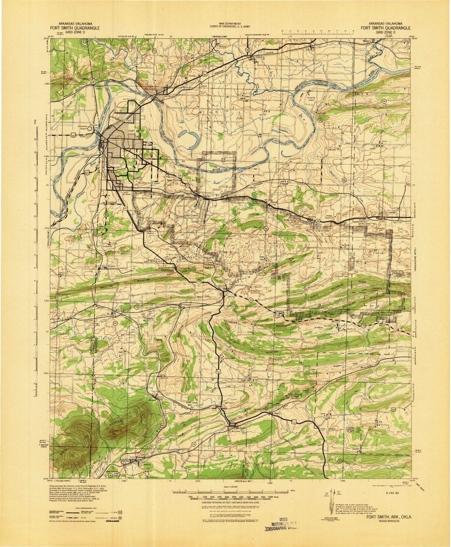
Historical USGS topographic map of Fort Smith in the state of Arkansas. Scale: 1:125000. Print size: 18" x 24"
This map was published in 1943 and is in the following counties: Crawford, Franklin, Le Flore, Logan, Scott, Sebastian, Sequoyah.
The map contains contour lines, roads, rivers, towns, streams, and lakes. Printed on high-quality waterproof paper with UV fade-resistant inks.
Contains the following named places: Adamson Creek, Arbuckle Island, Arbuckle Island Cutoff, Backbone Mountain, Backbone Narrows, Bear Creek, Big Branch, Big Creek, Big Creek Narrows, Billcol Mountain, Biswell Hill, Bloomer Ridge, Blythe Ridge, Bradshaw Narrows, Butlers Ridge, Cedar Creek, Coal Ridge, Cottonwood Slough, Courthouse Slough, Cox Creek, Creekmore Park, Crooked Slough, Curry Branch, Dam Site North Public Use Area, Dam Site South Public Use Area, Diffy Mountain, Doctors Creek, Donahoe Ridge, Elder Branch, Flat Rock Creek, Flat Rock Creek, Frustee Bend Cutoff, Gin Creek, Grand Ridge, Grand Ridge, Grayson Creek, Green Ridge, Griffith Mountain, Hackett Creek, Hall Creek, Huntington, Island, Liberty Church, Little Vache Grasse Creek, Little White Oak Ridge, Long Ridge, Mackenay Creek, Mays Branch, Mebane Ridge, Midland Peak, Mill Creek, Mill Creek, Oak View Farm, Onion Creek, Pigeon Creek, Pine Hill, Pinnacle Ridge, Pleasant Ridge, Polecat Branch, Prairie Branch, Prairie Creek, Prairie Creek, Rattlesnake Narrows, Rye Hill, Sand Ridge, Sandy Branch, Scott Ridge, Short Mountain, Spredding Ridge, Sulphia Springs Branch, Tadpole Branch, Tilles Park, Turkey Creek, Vache Grasse Creek, Vesta, Vineyard Branch, Vineyard Creek, Washburn Mountains, West Arkansas Regional Park, White Oak Mountains, White Rock Mountain, Young Ridge, Doctors Fork, Beverly, Barber Ridge, Molly Gap Creek, Kay Rodgers Park, Greenwood, Miliking Park, Fort Smith National Historic Site, Hunt Park, Saw Mill, White Bluff, Haw Branch, Emert Branch, Buckner Park, Heartsill Creek, Hester Creek, Bell Park, Bear Hollow, Rena, Van Buren Municipal Park, Flat Rock Creek, Springhill Park, Ben Geren Regional Park, Crescent, Jenny Lind, Cross Lanes, Haroldton, Westville, Barber, Barling, Bashe, Big Rock, Bloomer, Bonanza, Brooks Stephins Mountain, Buell, Burnville, Butlers Knob, Carnis, Catcher, Cavanaugh, Christmas Knob, Coal Ridge, Concord, Diamond Grove, Donahue Mountain, Dora, Enterprise, Fort Chaffee, Furry, George Mountain, Gray Mountain, Greenwood, Greenwood Junction, Grober Mountain, Howard Hill, Jenson, Massard, Meadows, Mill Creek, Milltown, New Haroldton, New Town, Oak Grove, Oak Park, Old Jenny Lind, Pinnacle Mountain, Pleasant View, Potato Hill, Riverdale, Shibley, Skinner Hill, Slaytonville, South Fort Smith, Ursula, West Hartford, White Bluff Mountain, Wildcat Mountain, Wright Town, Vesta Gas Field, Carol Ann Cross Park, Central Mall Shopping Center, Colony Square Shopping Center, Green Pointe Shopping Center, Martin Luther King Park, Park Plaza Shopping Center, Phoenix Village Shopping Center, Stonewall Village Shopping Center, Waldron Square Shopping Center, Woodlawn Park, Booneville Gas Field, Glendale, Cahinnio Camp, Rogers Camp, Alma Gas Field, Cedars Country Club, Cloverleaf Plaza Shopping Center, Crawford County Industrial Park, Eastgate Place, Goose Harbor Marina, Greenwood Junction Gas Field, Hollis Lake Gas Field, Kibler Gas Field, Lake Louemma Park, Meyer Park, North Hills Plaza Shopping Center, Pointers Athletic Field, Section 10 Gas Field, Shibley Gas Field, Van Buren Historic District, Mansfield Gas Field, Township of Ivy, Township of Mill Creek, Township of Prairie, Township of Weaver, Sugar Loaf Mountains, Andrews Field, Belle Grove Historic District, Bloomer Gas Field, Bonanza Gas Field, Bragg Gas Field, Burna, Essex Place Shopping Center, Fianna Hills Country Club, Fianna Hills Shopping Center, Fort Smith Country Club, Fort Smith Racquet Club, Grand Plaza Shopping Center, Harley Wilson Park, Harper Stadium, Latture Park, Lavaca Gas Field, Laville Shopping Center, Maybranch Shopping Center, Midland Mall Shopping Center, Ewing Gas Field, Quarry Shopping Center, Riverfront Park, Sunnymede Shopping Center, The Oaks Shopping Center, Town East Shopping Center, Towne West Shopping Center, West Garrison Avenue Historic District, Williamsburg Square Shopping Center, Township of Alma, Township of Dora, Township of Dyer, Township of Van Buren, Township of Vine Prairie, Township of Barber, Township of Tomlinson, Township of Lewis, Township of Tomlinson, Township of Upper