
MyTopo
Historic 1896 Freemont Nebraska 30'x30' Topo Map
Couldn't load pickup availability
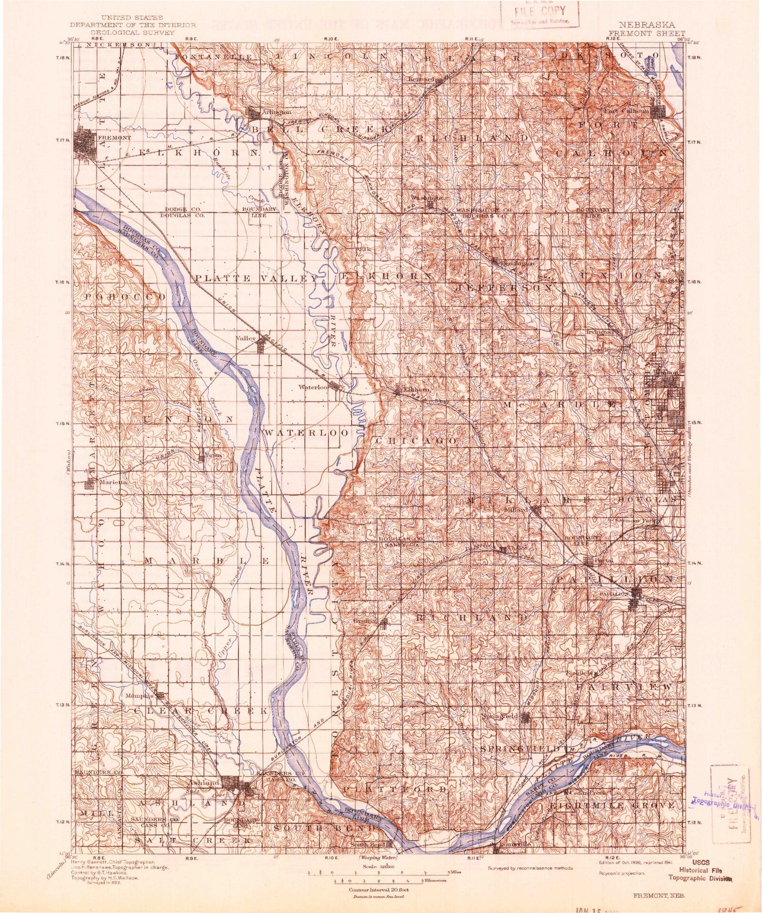
Historical USGS topographic map of Freemont in the state of Nebraska. Scale: 1:125000. Print size: 17" x 24"
This map was published in 1896 and is in the following counties: Cass, Dodge, Douglas, Lancaster, Pottawattamie, Sarpy, Saunders, Washington.
The map contains contour lines, roads, rivers, towns, streams, and lakes. Printed on high-quality waterproof paper with UV fade-resistant inks.
Contains the following named places: Ak Sar Ben Field, Arlington, Ashland, Beacon View, Bell Creek, Bennington, Benson Park, Barnard Park, Big Slough, Boston Branch, Boxelder Creek, Boys Town, Briggs, Brown Creek, Buffalo Creek, Butter Flat Creek, Callahan Creek, Camp Maha, Cedar Creek, Cedar Creek, Chalco, Circle R Camp, John C Fremont City Park, Lake Clagus, Clear Creek, Cole Creek, Crestview Lodge, DeSoto Lake, De Soto, De Soto National Wildlife Refuge, Debolt, Diversion Channel, East Fork Big Papillion Creek, Elk City, Elkhorn, Elkhorn River, Elm Creek, Elmwood Park, Falls Branch, Fort Calhoun, Fremont, Grace Young Park, Green Meadows, Gretna, Hell Creek, Hinz Fork, Irvington, Johnson Creek, Kennard, King Lake, Kings Lake, La Vista, Lake Platte View, Leach Branch, Leshara, Linoma Beach, Little Papillion Creek, Louisville Recreation Grounds, Masonic Park, Mead, Meadow, Memorial Park, Memphis, Memphis Lake, Memphis Lake State Recreation Area, Mercer, Midland Park, Mill Creek, Millard, Moeller Park, Moores Creek, Mosquito Creek, North Branch West Papillion Creek, Northwest Branch Big Papillion Creek, Northwest Branch Papillion Creek, Oak Park, Otoe Creek, Otoe Creek, Papillion, Pawnee Creek, Peony Park, Pleasure Lake, Ralston, Rawhide Creek, Rawhide Creek (Old Channel), Ray Creek, Rellers Park, Richfield, Richter Branch, Riverside Lakes, Roberts Park, Ruwe Park, Saint James Orphanage, Salt Creek, Seymour L Smith Park, Silver Creek, South Bend, South Papillion Creek, Southwest Branch Big Papillion Creek, Springfield, Springfield Creek, Lake Taormina, Thomas Creek, Timber Lodge Lake, Turkey Creek, Turkey Creek, Turtle Creek, Twin Brooks Camp, Two Rivers Farm, Two Rivers State Recreation Area, Upper Clear Creek, Valley, Van Anda Park, Venice, Wahoo Creek, Wann, Washington, Waterloo, West Papillion Creek, Western Sarpy Ditch, Wilburn Island, Woodcliff, Yutan, Abel, Cullom, Lane, Melia, Portal, Riverside, Douglas County, Sarpy County, Ashland Country Club, Omaha Country Club, Skyline Woods Country Club, Standing Bear Lake, Township of Ashland, Township of Clear Creek, Township of Elkhorn, City of Fremont, Township of Leshara, Township of Marble, Township 1, Township 2, Township 7, Township of Union, Lonergan Dam, Lonergan Lake, Boys Town Dam Number 3, Boys Town Reservoir Number 3, Wiebe Dam, Wiebe Reservoir, Papillion Creek Dam D-45, Papillion Creek Reservoir D-45, Grade Stabilization Dam 2, Turtle Creek Reservoir 2, Armbrust Dam, Thousand Oaks Lake, Candlewood Dam, Candlewood Reservoir, Snyder Dam, Snyder Reservoir, Memphis Dam, Lang Dam, Lang Reservoir, Boys Town Dam Number 1, Boys Town Reservoir Number 1, Papillion Creek Dam D-38, Papillion Creek Reservoir D-38, Nelson Detention Dam, Nelson Reservoir, Lake Arrowhead Dam, Lake Arrowhead Reservoir, Papillion Creek Dam W-4, Papillion Creek Reservoir W-4, Papillion Creek and Tributaries Site 16 Dam, Standing Bear Reservoir, Nelson South Dam, Nelson South Reservoir, Nixon Dam, Nixon Reservoir, Papillion Creek Site 11 Dam, Glenn Cunningham Lake, Johnson Creek Dam 22-A, Johnson Creek Reservoir 22-A, Stratbucker Dam, Stratbucker Reservoir, Philpot Dam, Philpot Reservoir, Long Creek Dam, Long Creek Reservoir, Harvey Dam, Harvey Reservoir, Skyline, Masonic Eastern Star Home for Children, Grant Square, Bell Street Plaza, Park Place, Gateway Plaza, Parkview Plaza, Eastville Plaza, Fremont Mall, Fremont, Buch Park, Buckridge Park, Clemmons Park, Monnich Park, Paradise Estates, Regency II Mobile Home Park, Behlen Observatory, Victory Bell, Wann, Leshara, Ashland Grain Elevator, Ashland, Ox-Bow Trail Historical Marker, Wiggenhorn Memorial Park, Yutan Oto Indian Village Historical Marker, Yutan Country Club, Yutan, Mead, Woods Landing Campground and RV Park, Township of Blair, Fort Atkinson Trail, Kennard, Fort Atkinson Historical Marker, Lewis and Clark Camp Site Historical Marker, Fort Atkinson State Historical Park, Arlington, Washington County Fair Grounds, South Bend, Cullom, Prehistorical Burial Site Historical Marker, Louisville, Cedar Creek, Memorial to the American Bandshell Sculpture, Platte River Rest Area


