MyTopo
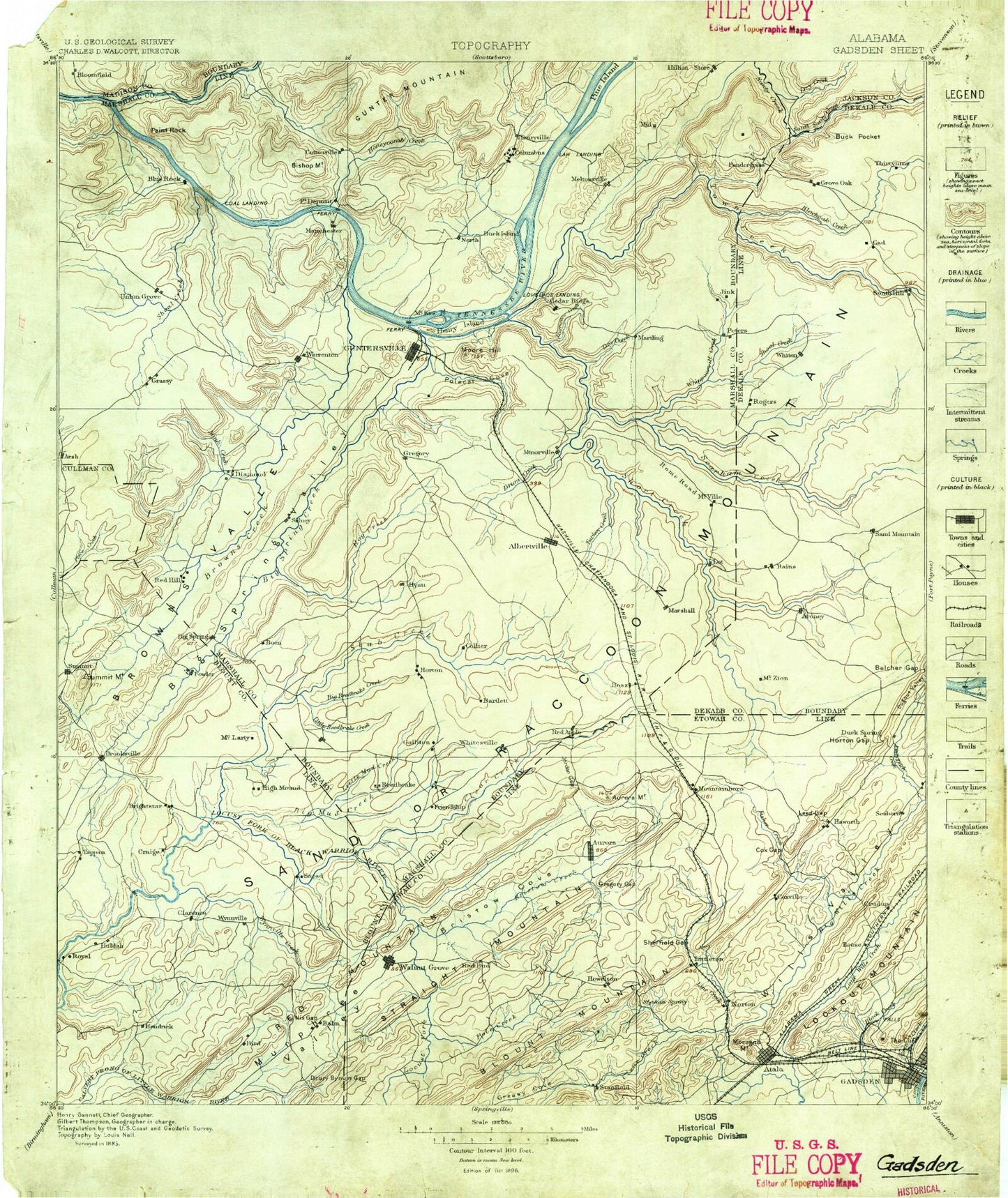
Historic 1885 Gadsden Alabama 30'x30' Topo Map
Couldn't load pickup availability
Historical USGS topographic map of Gadsden in the state of Alabama. Scale: 1:125000. Print size: 17" x 24"
This map was published in 1885 and is in the following counties: Blount, Cullman, DeKalb, Etowah, Jackson, Madison, Marshall.
The map contains contour lines, roads, rivers, towns, streams, and lakes. Printed on high-quality waterproof paper with UV fade-resistant inks.
Contains the following named places: Hales Creek, Noahs Ark, Aaron Branch, Alabama City, Albertville, Altoona, Altoona Mountain, Arab, Armstrong Creek, Aurora Lake, Back Hollow, Bailey Ridge, Baker Hill, Bald Knob, Bean Rock, Bean Rock Bluff, Bean Rock Creek, Beech Creek, Bellevue, Ben Johnson Ridge, Benson Branch, Berry Branch, Berry Branch, Berry Point, Bethune Point, Big Branch, Big Branch, Big Branch, Big Mud Creek, Big Reedbrake Creek, Big Spring Valley, Bishop Mountain, Bitty Branch, Black Center, Black Gap, Black Mountain, Blue Bend, Blue Rock Bluff, Boaz, Bob Mountain, Bob Walden Hollow, Booker Branch, Bristow Cove, Bristow Creek, Brock Branch, Brooksville, Brown Creek, Browns Creek, Browns Valley, Brushy Ridge, Bruton Gap, Bryant Mill Hollow, Buck Island, Bucks Pocket Tri-County Park, Bull Hollow, Bullocks Hollow, Busby Branch, Buzzard Branch, Camp Branch, Cane Tuck Hollow, Caney Hollow, Carlisle, Carroll Branch, Cave Mountain, Cedar Ridge, Center Point, Center Point, Chandler Branch, Chandler Ridge, Chestnut Flat, Susan Moore, Clark Bluff, Clark Hollow, Clayton Fish Pond, Clear Creek, Clear Creek, Clemons Branch, Cloud Mountain, Cold Branch, Cold Branch Hollow, Cold Springs Gap, Collins Creek, Columbus City, Cooks Branch, Corbinville, Cotton Sinks, Cox Gap, Cox Gap, Crooked Gap, Crossroads, Crudup, Curtiston, Davidson Hollow, Derrick Hollow, Dividing Ridge, Double Bridges, Double Bridges, Douglas, Drift Branch, Dripping Spring Branch, Drum Creek, Dry Creek, Dry Creek, Dry Creek, Dry Creek, Duvall Branch, Eades Branch, East Fork Drum Creek, Eddy Branch, Egypt, Ellenburg Mountain, Elrod Mountain, Fearn Branch, Feemster Gap, Fisher Creek, Fishers Hollow, Flat Branch, Fort Deposit Point, Fridays Crossing, Fry Gap, Fulks Point, Gandy Hollow, Georgia Mountain, Gilbreth Gap, Goat Island, Godwin Point, Grassy, Grassy Mountain, Graveyard Hill, Gross Hollow, Guntersville Dam, Guntersville Lake, Haigwood Branch, Hale Point, Hambrick Hollow, Hamby Branch, Hamby Branch, Handley Branch, Haney Mountain, Hanna Pond, Harrison Gap, Hayes Branch, Hebron, Hendrix, Henryville, High Point, Hilley Point, Hobson Gap, Hog Creek, Hog Creek Hollow, Holland Branch, Honey Bluff, Honey Branch, Honeycomb Creek, Hood Creek, Hopper, Horsepen Branch, Horseshoe Creek, Horsley Lake, Horton, Horton Gap, Horton Spring Branch, Howelton, Hurricane Branch, Hustleville, Hyatt, Ivalee, Jacob Creek, Jagger Hollow, Jim Cryar Hill, John Doss Mountain, John L Gap, John R Hollow, Johnson Hollow, Johnsons Mill, Jones Branch, Jones Creek, Jordan Gap, Jughandle Hollow, Kelley Ridge, Kenchelow Creek, Key Basin, King Gap, King Hollow, Kings Bend, Kirk Hollow, Lackey Gap, Lakeview, Lane, Lang Mountain, Lattiwood, Lawson Gap, Ledbetter Hollow, Lemon Branch, Lewis Mountain, Lindsey Hollow, Line Creek, Little Branch, Little Cove, Little Cove Creek, Little Drum Creek, Little Hog Creek, Little Mountain, Little Mud Creek, Little Paint Rock Creek, Little Reedbrake Creek, Little Slab Creek, Littleton, Long Hollow, Long Point, Louisville and Nashville Depot, Lucas Gap, Marshall County Park, Martin Hill, Martling, Martling Branch, Maynor Gap, Mayo Branch, Mayo Mountain, McCorkle Branch, McCorkle Mountain, McDermott Mountain, McDonald Hollow, McLarty, McVille, McWhorter Branch, Merrill Mountain, Mill Branch, Mill Creek, Mill Hollow, Mill Village, Mine Branch, Mining Pond Branch, Minky Creek, Mitchell Hollow, Moman Lake