MyTopo
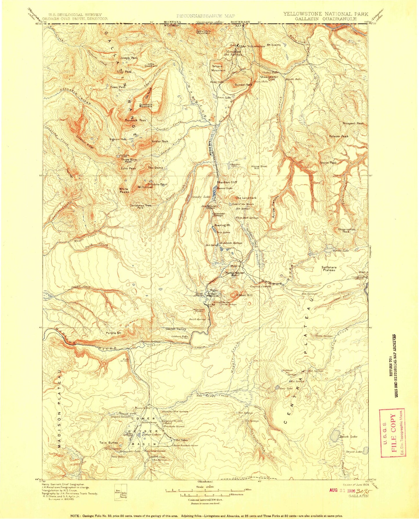
Historic 1908 Gallatin Wyoming 30'x30' Topo Map
Couldn't load pickup availability
Historical USGS topographic map of Gallatinin the states of Wyoming, Montana, Idaho. Scale: 1:125000. Print size: 17" x 24"
This map was published in 1908 and is in the following counties: Park, Teton.
The map contains contour lines, roads, rivers, towns, streams, and lakes. Printed on high-quality waterproof paper with UV fade-resistant inks.
Contains the following named places: Beaver Lakes Loop Trail, Blacktail Deer Creek, Lower Blacktail Trail, North Fork Fan Creek, Arrow Canyon, Arrow Canyon Creek, Bannock Peak, Beach Lake, Beaver Lake, Beaver Lakes Loop Trail, Bighorn Pass, Bighorn Pass Trail, Blacktail Deer Plateau, Blacktail Pond, Midway Bluff, Buffalo Meadows, Cache Lake, Canyon Creek, Cascade Lake, Cascade Meadows, Cascades of the Firehole, Cathedral Rock, Central Plateau, Clematis Creek, Cougar Creek Patrol Cabin, Cougar Creek Trail, Crowfoot Ridge, Crystal Falls, Culex Basin, Cygnet Lakes, Dryad Lake, East Fork Fan Creek, East Fork Fan Creek, Echo Peak, Elk Park, Elk Plaza, Mount Everts, Excelsior Geyser Crater, Fairy Creek, Fairy Creek Trail, Fairy Falls, Fawn Creek, Fawn Pass, Fawn Pass Trail, Firehole Canyon, Firehole Falls, Firehole Lake, Firehole River, Folsom Peak, Fountain Flats, Fountain Patrol Cabin, Gallatin Lake, Gardners Hole, Geyser Creek, Gibbon Canyon, Gibbon Falls, Gibbon Geyser Basin, Gibbon Hill, Gibbon Meadows, Gibbon River Rapids, Glen Creek, Gneiss Creek Trail, Golden Gate, Golden Gate Canyon, Goose Lake, Gray Lakes, Gray Peak, Grebe Lake, Grizzly Lake, Mount Holmes, Horseshoe Hill, Howard Eaton Trail, Ice Lake, Ice Lakes Trail, Indian Creek, Indian Creek Campground, Mount Jackson, Joseph Peak, Juniper Creek, Kingman Pass, Lake of the Woods, Lava Creek Campgrounds, Lava Creek Canyon, Lemonade Lake, Lilypad Pond, Little Quadrant Mountain, Lower Basin Lake, Lower Blacktail Trail, Lower Geyser Basin, Lupine Creek, Madison Canyon, Madison Range Overlook, Magpie Creek, Mallard Creek, Mammoth, Mary Lake, Mary Mountain, Mary Mountain Trail, Monument Geyser Basin, Nez Perce Creek, Norris Ranger Station, North Fork Fan Creek, Nuphar Lake, Observation Peak, Obsidian Canyon, Obsidian Creek, Obsidian Lake, Old Fountain Trail, One Hundred Spring Plain, Otter Creek, Oxbow Creek, Panther Creek, Phantom Lake, Pinyon Terrace, Plateau Trail, Porcupine Hills, Primrose Creek, Purple Mountain, Quadrant Mountain, Rabbit Creek, Roaring Mountain, Rush Lake, Rye Pond, Secret Valley, Secret Valley Creek, Sentinel Meadows, Sepulcher Loop Trail, Sheepeater Canyon, Sheepeater Cliffs, Sieve Lake, Silver Gate, Snowshoe Pass, Solfatara Creek, Spruce Creek, Stellaria Creek, Straight Creek, Surprise Pool, Tantalus Creek, The Crags, The Landmark, The Pocket, Three Rivers Peak, Trilobite Point, Twin Buttes, Twin Lakes, Violet Creek, Virginia Meadows, Washburn Range, White Creek, Willow Park, Winter Creek, Wolf Lake, Wolf Lake Trail, Wraith Falls, Lava Creek, Mount Holmes Trail, Rescue Creek Trail, Sportsman Lake Trail, Swan Lake Flat, White Peaks, Feather Lake, Goose Lakes, Monarch Geyser, Madison Junction, Norris Junction, Antler Peak, Bunsen Peak, Capitol Hill, Clagett Butte, Cook Peak, Cowan Creek, Dome Mountain, Gibbon River, Harlequin Lake, Mount Haynes, Lemonade Creek, Midway Geyser Basin, National Park Mountain, Norris Geyser Basin, Nymph Lake, Obsidian Cliff, Paintpot Hill, Prospect Peak, Rescue Creek, Rustic Falls, Sentinel Creek, Sepulcher Mountain, Snow Pass, Solfatara Plateau, Swan Lake, Tangled Creek, Terrace Mountain, The Hoodoos, Undine Falls, Virginia Cascade, Osprey Falls, Three Brothers Mountains, Yellowstone National Park, Gallatin Range, Hot Lake, Liberty Cap, Duck Rock, Opal Terrace, Pocket Basin, Porcelain Basin, Realgar Creek, Squirrel Springs Ridge, Highland Terrace, Main Terrace, Duck Creek, Beaver Lakes Loop Trail, Blacktail Deer Creek, Cottonwood Creek, Lower Blacktail Trail, North Fork Fan Creek, Beaver Lakes Loop Trail, Fawn Pass Trail, North Fork Fan Creek, Yellowstone National Park, Gallatin Range, Beaver Ponds, Yellowstone National Park