MyTopo
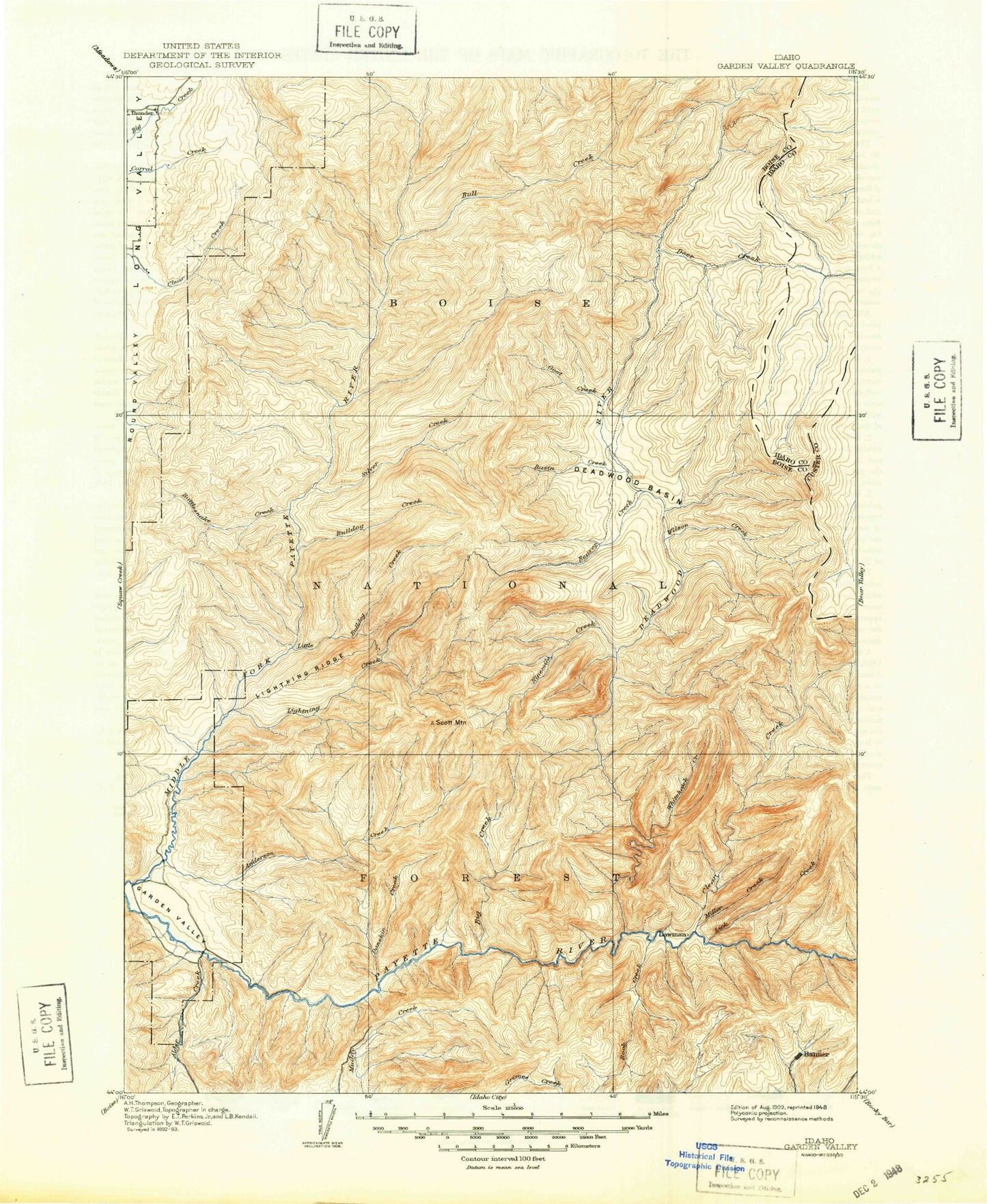
Historic 1909 Garden Valley Idaho 30'x30' Topo Map
Couldn't load pickup availability
Historical USGS topographic map of Garden Valley in the state of Idaho. Scale: 1:125000. Print size: 17" x 24"
This map was published in 1909 and is in the following counties: Boise, Valley.
The map contains contour lines, roads, rivers, towns, streams, and lakes. Printed on high-quality waterproof paper with UV fade-resistant inks.
Contains the following named places: Alpha Grange, Lightning Ridge, Stevens Point, Ucon Basin, Ader Gulch, Anderson Creek, Archie Creek, Ash Creek, Assay Creek, Auglebright Gulch, Bald Mountain, Banner Mine, Bear Wallow Creek, Beaver Creek Summit, Bell Creek, Bernard Creek, Bernard Lake, Bernard Mountain, Big Falls, Big Gallagher Creek, Big Spruce Creek, Birch Creek, Birch Flat, Bitter Creek, Black Bear Creek, Blacks Creek, Bog Forest Service Station, Boiling Springs Driveway, Boom Creek, Box Canyon, Bridge Creek, Brush Creek, Bryan Creek, Bull Creek, Bull Creek Trail, Bulldog Creek, Bummer Creek, Burn Creek, Burns Ridge, Calderwood Creek, Carlson Gulch, Carpenter Creek, Charlotte Gulch, Charters Creek, Clear Creek, Comeback Mine, Cooley Creek, Coulter Gulch, Cow Creek, Crane Meadow, Cup Creek, Cup Creek, Cupp Corral, Daisy Creek, Danskin Creek, Dash Creek, Deadwood Campground, Deadwood Jim Creek, Deadwood Lodge, Deadwood Mine, Deadwood Ridge, Deadwood River, Deadwood River Trail, Deer Creek, Deer Creek Pass, Dodge Creek, Easley Creek, East Fork Anderson Creek, East Fork Big Pine Creek, East Fork Clear Creek, East Fork Deadwood River, East Fork Horn Creek, East Fork Warm Springs Creek, East Mountain, East Mountain Way, Eby Creek, Eggers Creek, Emma Creek, Eureka Point, Fawn Creek, Fern Creek, Fir Creek, Fool Creek, Fool Creek Trail, Forks of Big Pine Creek Campground, Garden Valley, Gem County Stock Trail, Goat Creek, Goat Creek, Gold Creek, Golden Age Mine, Golden Chariot Mine, Golden Cycle Mine, Gooseberry Creek, Gotch Creek, Graney Creek, Granite Basin, Granite Creek, Granite Creek, Grayback Creek, Green Creek, Grimes Monument, Grimes Pass, Ground Hog Creek, Grouse Creek, Habit Creek, Hailey Creek, Hanks Creek, Hole in the Wall Creek, Hopkins Creek, Horn Creek, Horse Creek, Hot Spring Campground, Huckleberry Creek, Jackson Peak, Josie Creek, Julie Creek, Kesh Creek, Kirkham Creek, Kirkham Ridge, Koppes Creek, Lake Creek, Left Fork Danskin Creek, Lick Creek, Ligget Creek, Lightning Creek, Little Anderson Creek, Little Beaver Creek Trail, Little Camp Creek, Little Fall Creek, Little Falls, Little Gallagher Creek, Little Gooseberry Creek, Little Hole in the Wall Creek, Little Sams Creek, Logging Gulch, Long Creek, Long Fork Silver Creek, Long Gulch, Long Lake, Longs Creek, Lookout Canyon, Lorenzo Creek, Lower Deadwood Guard Station, Lower Ranger Station, Mammoth Mine, Mary Blue Mine, Mary Jane Mine, McKinzie Creek, Meadow Camp Creek, Meadow Creek, Middle Fork Big Pine Creek, Middle Fork Warm Springs Creek, Miller Creek, Missouri Mine, Mohawk Gulch, Monumental Creek, Monumental Peak, Monumental Trail, Moulding Creek, Mountain View Campground, Nellies Basin Creek, Nelson Creek, Ninemile Creek, No Man Creek, North Fork Deer Creek, North Fork Range, North Fork Whitehawk Creek, O'Keefe Creek, Onion Creek, Onion Valley, Oxbow Bend, Oxtail Creek, Packsaddle Campground, Packsaddle Creek, Park Creek, Park Creek Campground, Peace Creek, Peace Rock, Pilgrim Mountain, Pinch Gulch, Pine Creek, Pine Creek, Pine Creek, Pine Flat, Pinney Creek, Pole Creek, Poorman Creek, Porter Creek Trail, Powderhouse Gulch, Pyle Creek, Rattlesnake Gulch, Rattlesnake Point, Rattlesnake Trail, Reeves Creek, Reservoir Creek, Road Fork Creek, Rock Creek, Rocky Canyon, Rocky Peak, Ross Creek, Russell Creek, Sams Creek, Schoolhouse Creek, Schoolhouse Gulch, Scott Mountain, Scriver Creek, Shilling Creek, Silver Creek, Silver Creek Work Center, Silver Creek Lookout, Silver Creek Summit, Silver Creek Trail, Sixmile Creek, Sixmile Point, Sixteen-to-one Creek, Skid Road Creek, Skull Creek, Skunk Creek, Skunk Creek Trail, Slaughterhouse Creek, Slide Gulch, Slim Creek, Sloper Mine, Smith Creek, Smith Creek, Smokey Creek, South Fork Beaver Creek, South Fork Scott Creek, South Fork West Fork Creek, Specimen Mine, Station Creek, Steep Creek, Stevens Creek, Stratton Basin, Stratton Creek