MyTopo
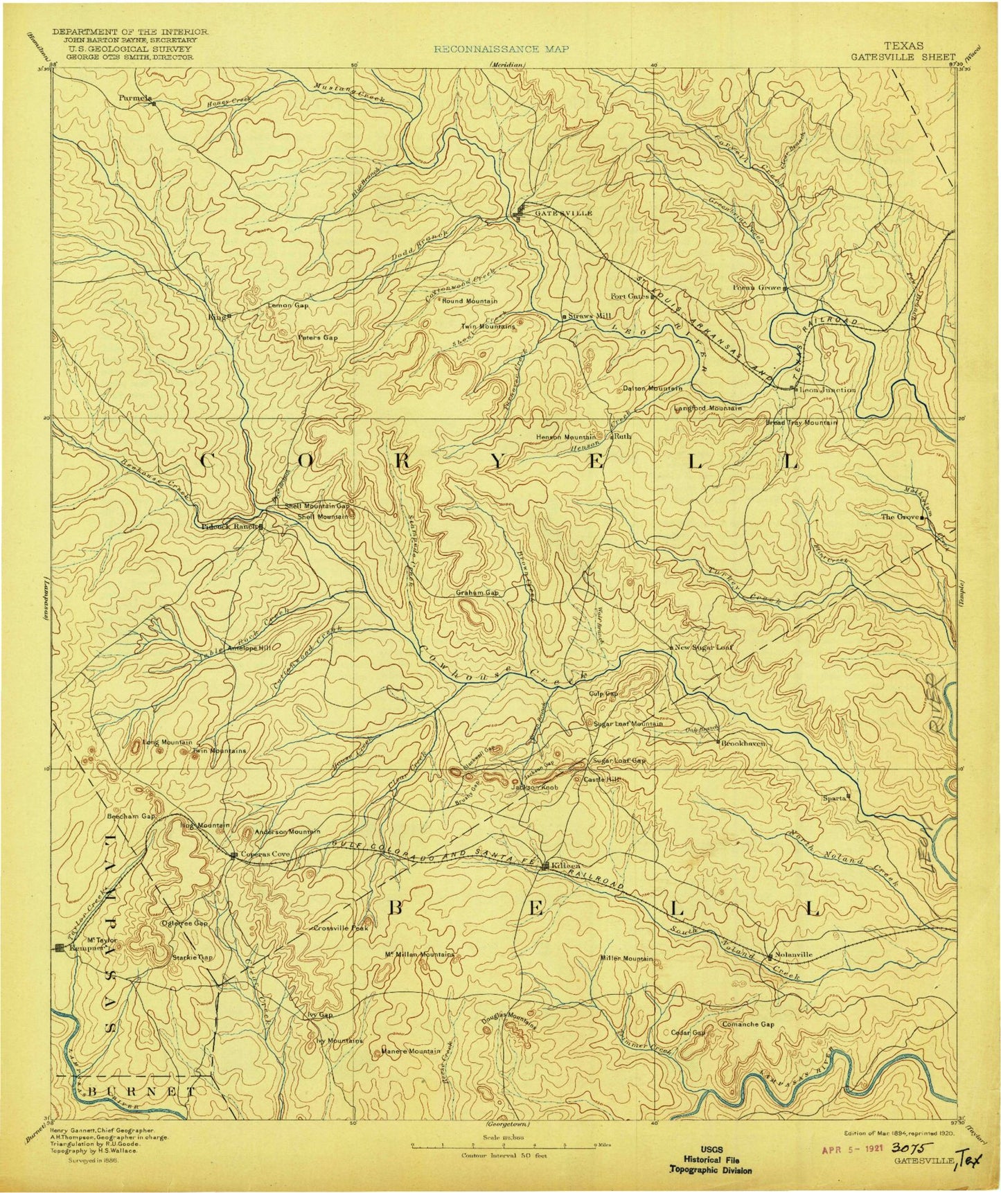
Historic 1894 Gatesville Texas 30'x30' Topo Map
Couldn't load pickup availability
Historical USGS topographic map of Gatesville in the state of Texas. Scale: 1:125000. Print size: 17" x 24"
This map was published in 1894 and is in the following counties: Bell, Burnet, Coryell, Lampasas, McLennan.
The map contains contour lines, roads, rivers, towns, streams, and lakes. Printed on high-quality waterproof paper with UV fade-resistant inks.
Contains the following named places: Panther Den Branch, Anderson Mountain, Antelope Mound, Arnett, Bagget Mountain, Bald Knob, Bald Knob, Bear Creek, Bee Creek, Bee House Creek, Beecham Gap, Belton Lake, Black Gap, Black Mountain, Blackwell Gap, Blackwell Mountains, Bland Mountain, Blue Branch, Lake Boyd Callan, Lake Bratcher, Bread Tray Mountain, Browns Creek, Bull Branch, Bull Run, Bushy Gap, Bushy Knob, Buttermilk Creek, Camp Branch, Camp Moonraker, Camp Tahuaya, Castle Mountain, Cedar Gap, Chaffee Village, Clabber Creek, Clabber Point, Clark Creek, Clear Branch, Clear Creek, Clear Creek, Conder Park, Copperas Cove, Copperas Point, Cottonwood Creek, Cottonwood Creek, Crossville Mountain, Culp Mountain, Dalton Mountain, Dana Peak, Dodd Branch, Douglas Mountains, Elm Knob, Elm Mountain, Flat, Flint Creek, Fort Hood Recreation Area, Fourmile Branch, Gatesville, Graham Gap, Gulps Gap, Hargrove Creek, Hay Branch, Henson Creek, Henson Mountains, Herzog Mountain, Hog Mountain, House Creek, Ivy Gap, Ivy Mountain, Jack Mountain, Jackson Gap, Jackson Knob, Kay Bee Heights, Killeen, Lake Henry, Langford Mountain, Leon Junction, Liese Field, Lone Mountain, Lone Star, Long Mountain, Manere Mountain, Manning Mountains, McBride Point, McCluskey Mountain, McMillan Mountains, McNair Village, Miller Mountain, Mound, Mountain, Mussie Lake, Nolanville, North Bee House Creek, North Branch Settlement Branch, North Greenbriar Creek, North Nolan Creek, North Reese Creek, Oak Branch, Oglesby, Ogletree Gap, Owl Creek, Owl Creek Mountains, Patterson Branch, Peni-Bilt Lake, Pew Branch, Pidcoke, Post Oak Mountain, Preachers Creek, Prichard Athletic Field, Purmela, Raby Park, Rambo Point, Rattlesnake Hill, Rattlesnake Point, Reed Mountain, Riggs Mountain, Riggs Run, Riley Branch, Ripstein Creek, Robinette Point, Round Mountain, Royalty Ridge, Settlement Branch, Shaw Branch, Shell Gap, Shell Mountains, Shell Point, Shoal Creek, Smith Mountain, Sorrells Creek, South Bee House Creek, South Branch Settlement Branch, South Greenbriar Creek, South Mountain, South Nolan Creek, South Purmela, Sparta Mountain, Stampede Creek, Stampede Mountan, Starkie Gap, Stephenson Branch, Stillhouse Branch, Stillhouse Hollow, Sugar Loaf Gap, Sugar Loaf Mountain, Taylor Branch, Taylor Mountain, The Grove, The Narrows, Topsey, Trapnell Point, Turkey Run, Turnover Creek, Twin Mountains, Two Year Old Creek, Variety Club Boys Ranch, Waddle Hollow, Walker Village, Williamson Mountain, Willow Springs Community Center, Wolf Point, Coryell Creek, Cowhouse Creek, Egypt Hollow, King Mountain, North Table Rock Creek, Plum Creek, Sevenmile Mountain, Table Rock Creek, Wolf Creek, Antelope Crossing, Bland, Brookhaven, Cavitt, Cold Springs, Curry Crossing, Fort Gates, House Crossing, Jackson Crossing, King, Lime City, Mason Crossing, Middle Crossing, Owl Creek, Riggs Ford, Slater, Union Grove, Union Hill, Coryell County, Little Trimmier Creek, Stillhouse Hollow Lake, Trimmier Creek, Starnes Lake Number Two, Taylor Creek, Burnet Branch, Comanche Gap, Perryman Creek, Starnes Lake Number One, Binnion Creek, Westcliff, Midway Drag Strip, Fauntleroy Park, Fort Gates, Copperas Cove City Park, Copperas Cove Municipal Golf Course, Abrams Field House, Comanche Village I, Comanche Village II, Comanche Village III, Heiner Lake, Larned Lake, Liberty Hill, Liberty Hill Motocross Track, Nolan Lake, Owl Creek Park, Owl Creek Wildlife Management Area, Sparta Valley Park, Copperas Hill Estates Park, Heritage Park, Highland Park, Cedar Gap Park, Community Center Park, Kern Park, Long Branch, Long Branch Park, Marlboro Park, Camp Arrowhead Boy Scout Camp, Chalk Ridge Falls, Chalk Ridge Falls Park, Christian Farms, Church of Christ Campground, Dana Peak Park, Overlook Park, Riversbend Park, Stillhouse Park, Union Grove Park, Westcliff Park