MyTopo
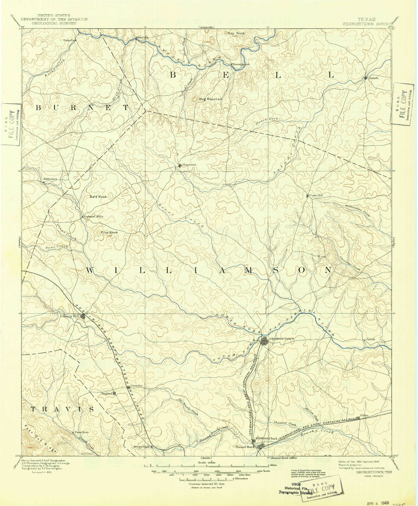
Historic 1893 Georgetown Texas 30'x30' Topo Map
Couldn't load pickup availability
Historical USGS topographic map of Georgetown in the state of Texas. Scale: 1:125000. Print size: 18" x 24"
This map was published in 1893 and is in the following counties: Bell, Burnet, Travis, Williamson.
The map contains contour lines, roads, rivers, towns, streams, and lakes. Printed on high-quality waterproof paper with UV fade-resistant inks.
Contains the following named places: North Sam Gabriel Dam, Anderson Branch, Andice, Apple Spring Hollow, Bald Knob, Barnes Hollow, Barnett Knob, Bear Creek, Bee Cave Hollow, Bell Gin, Bennett Branch, Berry Creek, Bertram Branch, Big Sandy Creek, Bingham Creek, Bittick Hollow, Block House Creek, Bloody Hollow, Bone Hollow, Brewer Branch, Briggs, Brizendine Branch, Brown Hollow, Bullion Branch, Bullion Hollow, Buttermilk Creek, Buttermilk Hollow, Camp Spring Hollow, Campbells Branch, Cedar Bluff, Cedar Hollow, Cedar Knob, Cedar Park, Chandler Branch, Cherry Hollow, Cherry Hollow, Clear Creek, Cold Springs Hollow, Corn Hill, Cottonwood Creek, Cowan Creek, Crockett Gardens, Dam Number 1, Dam Number 13A, Dam Number 2, Dam Number 3, Dam Number 4, Dam Number 5, Deep Hollow, Dewberry Hollow, Ding Dong, Dog Branch, Double Hollow, Dry Berry Creek, Dry Branch, Dry Fork Creek, Dyer Branch, Dyeus Branch, East Branch Clear Creek, East Fork Ranger Branch, Florence, Flying K Ranch, Forty Acre Hollow, Gabriel Mills, Gann Branch, Gay Hollow, Georgetown, Gillum Hollow, Glover Branch, Hamilton Branch, Hamilton Hill, Hawks Nest Hollow, Heinatz Flat, Hickman Knob, Hicks Hollow, Hog Mountain, Horse Thief Mountain, Hunt Hollow, Hutto, Indian Lake, Jarrell, Jenkins Branch, Jennings Branch, Jess Maynard Hill, Jim Hogg Hollow, Jinks Branch, Jonah, Keelersville, Lackey Creek, Lake Creek, Leander, Liberty Hill, Little Barnes Hollow, Little Creek, Long Hollow, Long Mountain, Martha Chapman Dam, Mason Creek, Mason Hollow, Maxdale Community Center, McDaniel Branch, Middle Fork San Gabriel River, Mileham Branch, Mill Creek, Miller Branch, Morrison Ridge, Mustang Creek, Nameless, Nameless Hollow, New Corn Hill, North Cherry Hollow, North Fork Brushy Creek, North Fork Donahoe Creek, North Georgetown, North Rocky Creek, North Rumsey Creek, North Salado Creek, Oakalla, Onion Branch, Onion Creek, Owen Flat, Ox Hollow, Paisano Peak, Palmetto Hollow, Pecan Branch, Pilot Knob, Polecat Knob, Post Oak Creek, Potts Branch, Prairie Dell, Queen Hill, Rabbit Hill, Ramsey Nursery Branch, Ranger Branch, Reese Creek, Rock Creek, Rock House, Rocky Creek, Rocky Creek, Rocky Hollow, Rocky Hollow, Round Mountain, Round Mountain, Round Rock, Rumsey Creek, Salado, Sandy Creek Arm, Sawyer Hollow, Schoolhouse Hollow, Schwertner, Sheep Hollow, Smith Branch, Snake Hollow, Solana Ranch, South Berry Creek, South Brushy Creek, South Cherry Hollow, South Fork Brushy Creek, South Fork Mustang Creek, South Rocky Creek, South Rumsey Creek, South Salado Creek, Sowes Branch, Spanish Oak Creek, Spring Hogg Hollow, Stapp Branch, Stillman Valley, Stillman Valley Creek, Sunset Ranch, Sycamore Branch, Sycamore Hollow, Sycamore Springs Creek, Taylor Ray Hollow, Theon, Toby Hollow, Tom Adams Hollow, Tucker Knob, Turnbow Mountain, Walburg, Walnut Spring Hollow, Watkins Branch, Weir, Weir Branch, West Branch Clear Creek, West Fork Smith Branch, White Rim Mountain, White Stone, Williams Branch, Williams Hollow, Williams Hollow, Willingham Branch, Wilson Branch, Wilson Branch, Wolf Ridge, Youngsport, Big Branch, Big House Branch, Cobbs Springs Branch, Glasscock Branch, McNutt Creek, North Fork San Gabriel River, Pecan Springs Branch, Smalley Branch, Smith Branch, South Fork San Gabriel River, Big Bear Hill, Lake Georgetown, Greens Crossing, Hunt Crossing, Jinks Branch, Mahomet, Maxdale, Mozo, Russell Crossing, Seward Junction, Walkerton, Williamson County, Soil Conservation Service Site 10a Dam, Soil Conservation Service Site 10a Reservoir, Soil Conservation Service Site 10b Dam, Soil Conservation Service Site 10b Reservoir, Soil Conservation Service Site 11 Dam, Soil Conservation Service Site 11 Reservoir, Soil Conservation Service Site 12 Dam, Soil Conservation Service Site 12 Reservoir, Soil Conservation Service Site 14 Dam, Soil Conservation Service Site 14 Reservoir, Soil Conservation Service Site 15 Dam, Soil Conservation Service Site 15 Reservoir, Soil Conservation Service Site 16 Dam, Soil Conservation Service Site 16 Reservoir, Soil Conservation Service Site 17 Dam, Soil Conservation Service Site 17 Reservoir, Soil Conservation Service Site 18 Dam, Soil Conservation Service Site 18 Reservoir, Soil Conservation Service Site 19 Dam