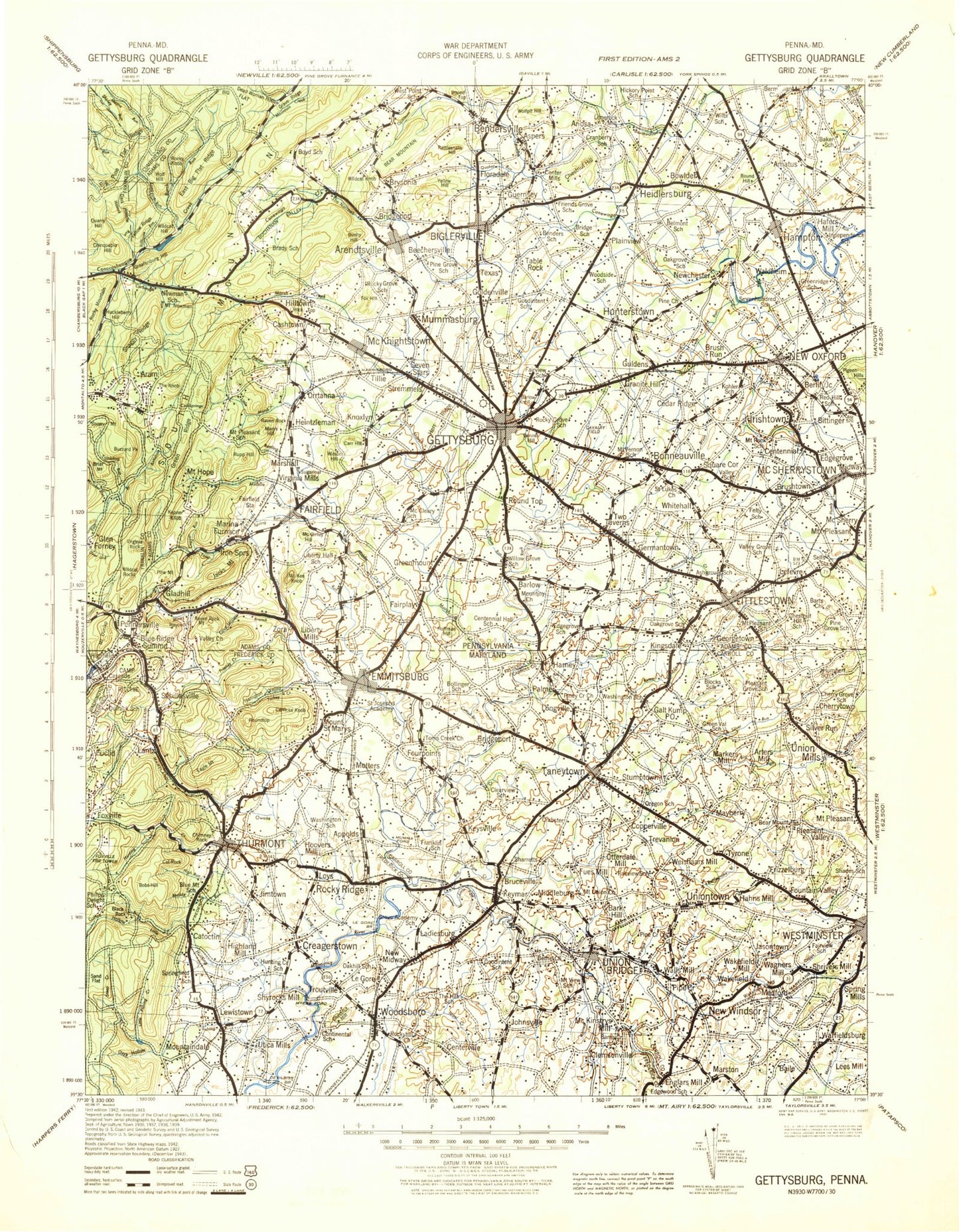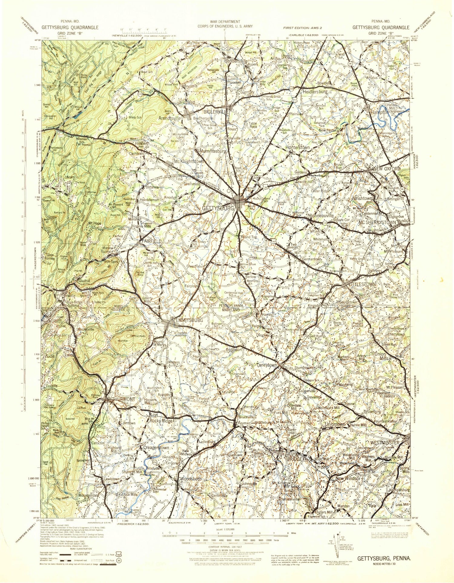
MyTopo
Historic 1942 Gettysburg Pennsylvania 30'x30' Topo Map
Couldn't load pickup availability
Historical USGS topographic map of Gettysburg in the state of Pennsylvania. Scale: 1:125000. Print size: 17" x 24"
This map was published in 1942 and is in the following counties: Adams, Carroll, Cumberland, Franklin, Frederick, Washington, York.
The map contains contour lines, roads, rivers, towns, streams, and lakes. Printed on high-quality waterproof paper with UV fade-resistant inks.
Contains the following named places: Alloway Creek, Flat Run, Middle Creek, Piney Creek, Toms Creek, Mason and Dixon Line, Arendtsville, Aspers, Bakers Knob, Bare Rock, Bear Mountain, Beaverdam Creek, Beechersville, Bendersville, Bendersville Station, Benner Hill, Big Flat, Big Hill, Biglerville, Birch Run, Blue Ridge Summit, Bonneauville, Briar Mountain, Bridgeport, Brush Run, Brushtown, Brysonia, Buchanan Valley, Bushy Hill, Buzzard Park, Buzzards Roost, Caledonia Golf Course, Caledonia Park, Camp Nawakwa, Carbaugh Run, Cashtown, Cemetery Hill, Centennial, Center Mills, Center Mills Station, Chamberlains Hill, Charmian, Chestnut Hill, Chicken Run, Chimney Rocks, Chinquapin Hill, Clear Run, Clermont Crag, Copper Run, Corls Ridge, Cove Hollow, Cranberry Valley, Cross Keys, Culp Ridge, Culps Hill, Dark Hollow, Devils Den, Devils Run, Edgegrove, Fairfield, Fairfield Station, Fairplay, Fountain Dale, Fox Hill, Friends Creek, Furnace Dam, Gardner Run, Germantown, Gettysburg National Military Park, Gettysburg Park, Goldenville, Graefenburg Hill, Granite Hill, Granite Hill Station, Grave Ridge, Green Ridge, Green Ridge, Green Run, Green Springs, Greenmount, Guldens, Hampton, Hanover Reservoir, Harpers Hill, Haycock, Hayes Run, Heidlersburg, Herr Ridge, Hilltown, Hosack Run, Huckleberry Hill, Hunterstown, Indian Run, Irishtown, Iron Springs, Jacks Mountain, Jacks Mountain Tunnel, Kepner Knob, Carr Hill, Kingsdale, Knob Run, Wilson Hill, Little Marsh Creek, Littles Run, Long Pine Run, Lousy Run, Ludwigs Hill, Maria Furnace, Markel Run, Marsh Creek, Marsh Creek Hollow, Marys Hill, Mc Ginley Hill, Mc Kee Hill, McKnightstown, McKnightstown Station, McMillan Woods, McSherrystown, Methodist Hill, Midway, Miney Branch, Mitten Hill, Monterey, Monterey Peak, Monument Rock, Mount Hope, Mount Misery, Mount Pleasant, Mount Pleasant, Muddy Run, Mummasburg, Mummasburg Run, New Oxford, Newchester, Mount Newman, Oak Ridge, Old Forge, Opossum Creek, Orebank Hill, Orrtanna, Pennersville, Pigeon Hill, Pine Run, Pleasant Dale Creek, Plum Creek, Plum Run, Plum Run, Plum Run, Powers Hill, Quaker Run, Quaker Valley, Quarry Gap Hill, Quarry Hill, Raccoon Creek, Ram Hill, Rampike Hill, Rattlesnake Hill, Rattlesnake Run, Rattling Run, Raven Rock Mountain, Rock Creek, Rocky Knob, Rocky Mountain Creek, Round Hill, Round Top, Round Top, Rupp Hill, Sells Station, Seven Stars, Sharps Run, Sheep Heaven, Sier Hill, Snaggy Ridge, Snowy Mountain, South Mountain, South Mountain, Spring Run, Stevens Run, Stillhouse Run, Stone Jug Hill, Strasbaugh Hill, Sugar Loaf, Swamp Creek, Swift Run, Table Rock, Table Rock Station, The Angle, The Knob, The Narrows, The Peach Orchard, The Pines, The Wheatfield, Trucker Run, Tumbling Run, Tunnel Hill, Two Taverns, Tysons Hill, Virginia Mills, Virginia Rock, Waynesboro Dam, Waynesboro Reservoir, Wenksville, White Run, Whitehall, Wigwam Hill, Wildcat Hill, Wildcat Knob, Wildcat Rocks, Willoughby Run, Wolf Hill, Wolf Hill, Wolfpit Hill, Yellow Hill, Poplar Spring Creek, Big Flat Ridge, Big Pine Flat Ridge, Mount Dunlop, East Big Flat Ridge, Gladhill, Little Round Top, Long Pine Run Reservoir, Michaux State Forest, Middle Creek, Muskrat Run, Piney Mountain, Rock Top, Round Top, Seminary Ridge, South Branch Conewago Creek, Toms Creek, Yellow Ridge, Lake Heritage Dam, Section F Dam, K Section Dam, K Section Pond, Sheppard Dam