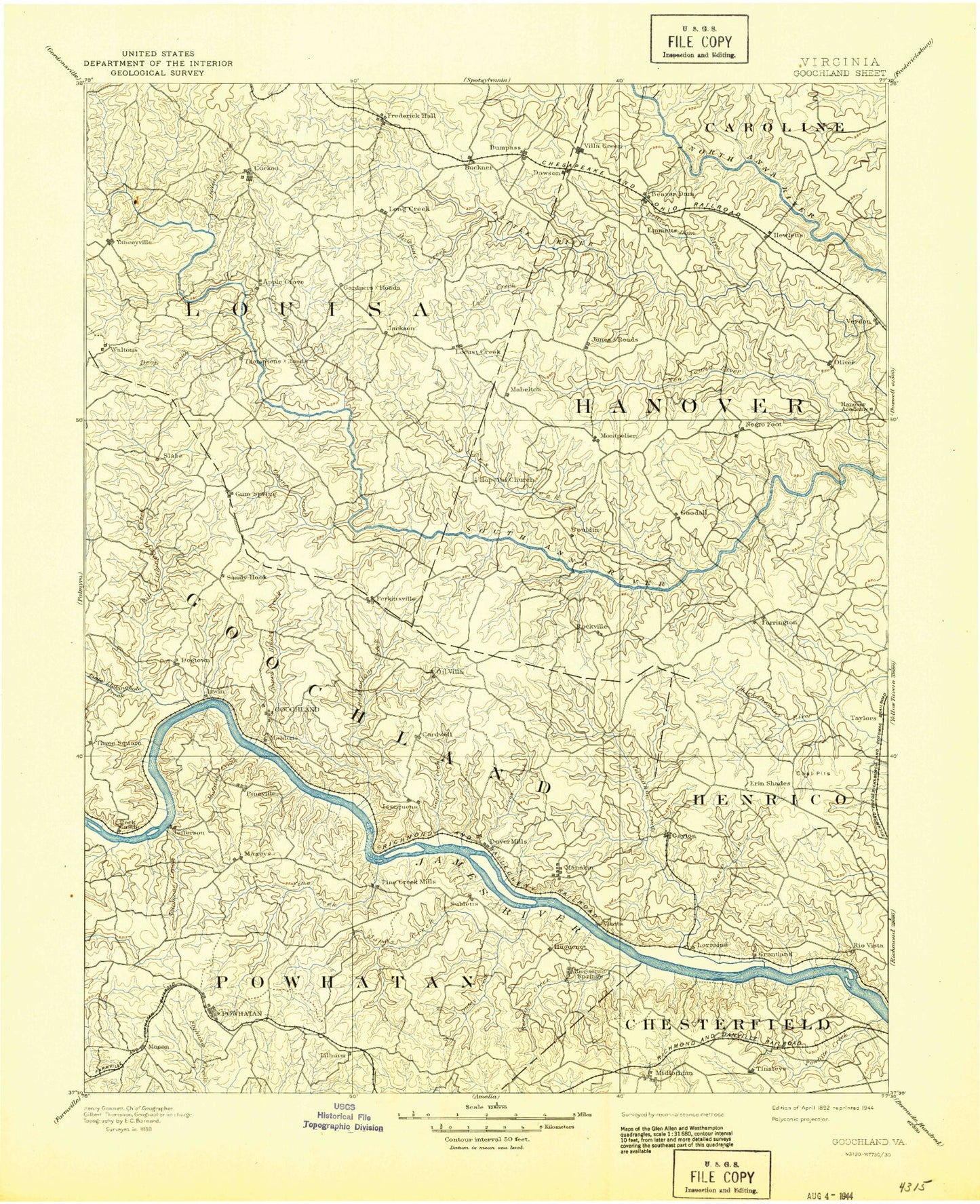
MyTopo
Historic 1892 Goochland Virginia 30'x30' Topo Map
Couldn't load pickup availability
Historical USGS topographic map of Goochland in the state of Virginia. Scale: 1:125000. Print size: 17" x 24"
This map was published in 1892 and is in the following counties: Caroline, Chesterfield, Goochland, Hanover, Henrico, Louisa, Powhatan, Richmond (city), Spotsylvania.
The map contains contour lines, roads, rivers, towns, streams, and lakes. Printed on high-quality waterproof paper with UV fade-resistant inks.
Contains the following named places: Allens Branch, Anderson Creek, Bearden Pond, Beaver Creek, Beaver Creek, Beaverdam Creek, Beaverdam Creek, Beech Creek, Bernards Creek, Beverly Hills Shopping Center, Big Lickinghole Creek, Big Swamp, Black Haw Branch, Blackheath Pond, Bosher Dam, Branch Creek, Broad Branch, Bryant Pond, Bumpass, Cabin Branch, Campbells Creek, Cattail Creek, Cattail Creek, Cedar Creek, Cheneys Creek, Cherokee Lake, Chilesburg, Coleman Creek, Colley Swamp, Courthouse Creek, Cub Creek, Deep Creek, Deep Creek, Deep Run, Desper Creek, Dickens Creek, Dog Branch, Dogtown, Dover Creek, Dutoy Creek, Duval Pond, East Branch Tuckahoe Creek, East Fork Genito Creek, Fine Creek, Fine Creek Mills, Flat Branch, Fleming Millpond, Flemings Creek, Fork Creek, Fredericks Hall, Fulcher Millpond, Gaddes Creek, Gammons Creek, Gammons Store, Genito Creek, Georges Branch, Girl Scout Camp, Glenbrook Pond, Goldmine Creek, Goodwins Store, Grassy Swamp Creek, Grigg Lake, Gum Spring, Hanover Academy, Hawkins Creek, Hawkins Creek, Hoehns Lake, Hogan Creek, Holladay Branch, Hollowing Creek, Holly Grove, Horsepen Branch, Horsepen Creek, Hughes Creek, Hylas, Indian Creek, Jones Creek, Jones Creek, Jones Swamp, Laurel, Leatherwood Creek, Little Creek, Little Lickinghole Creek, Little River, Little Tuckahoe Creek, Locust Creek, Long Creek, Marine Spring Branch, Meredith Branch, Michauk Creek, Mill Creek, Mill Creek, Millpond Branch, Mohawk Creek, Mont Air Creek, Mount Nebo, Needstan Creek, Negro Foot, North Fork Little River, Northeast Creek, Norwood Creek, Old Bandana, Old Miss Branch, Oldhouse Branch, Orchid, Orchid Lake, Overhill Lake, Owens Creek, Perkinsville, Piney Branch, Powhatan State Wildlife Management Area, Pug Swamp, Rattlesnake Creek, Readers Branch, Redeye Creek, Roan Horse Creek, Roberts Branch, Rock Castle, Rock Ford Creek, Rocketts Creek, Rockville, Rooty Branch, Sabot Island, Salles Creek, Salmon Creek, Shaaf Pond, Shadow Pond, South Branch Fork Creek, Young Creek, Lake Shawnee, Sherman Lake, Shop Creek, Snelson Creek, Solomons Creek, Spicers Lake, Stagg Creek, State Farm, Stone Horse Creek, Stony Run, Sunfish Pond, Swift Millpond, Tanyard Creek, Taylors Creek, Teman, Three Square, Three Square Creek, Tuckahoe Creek, Tuckahoe Island, Tuckahoe Shopping Center, Turkey Creek, Turners Creek, Tylers, Walkers Creek, Watleg Branch, West Fork Genito Creek, Westham Creek, White Hall Creek, Wolf Swamp, Cardwell, Cedar Fork, Coffey Corner, Crozier, Dongola, East Leake, Goodall, Goshen Cross Road, Hadensville, Irwin, Jefferson, Jones Corner, Lanes Corner, Lone Oak, Lorraine, Mabelton, Michaux, Moodys Corner, Mount Garland, Oliver, Othma, Provost, Robious, Yanceyville, South Anna, Subletts, Threemile Corner, Verdon, Vontay, Hewlett, James River and Kanawha Canal, Little Westham Creek, Williams Island, Holstrum Dam, Holstrum Pond, James Dam, James Pond, Lake Caroline Dam, USRY Properties Incorporated Dam, Lake Page Dam, Rock Creek Park Dam, Rock Creek Park Lake, Lake Cherokee Dam, Reed Dam, Salisbury Lake Dam, Salisbury Lake, Lake Patrick Henry Dam, Lake Patrick Henry, Mount Bernard Dam, Mount Bernard Lake, Dover Dam, Lake Killerney Dam, Lake Killerney, Licking Hole Farm Dam, Licking Hole Farm Pond, Bolling Hall Dam, Bolling Hall Lake, Pruitts Dam, Pruitts Pond, Broad Branch Dam, Broad Branch Lake, Fairfield Dam, Fairfield Pond, Lake Fullstream Dam, Lake Fullstream, Richmonds Dam, Richmonds Pond, Carter and Harrell Dam, Carter and Harrell Lake, United Methodist Centers Dam, Patterson and Stittius Dam, Gathrights Dam, Childress Dam, Reynolds Dam, Horseshoe Pond, Bowles Dam, Harris Pond Dam, South Anna Number 52b Dam