MyTopo
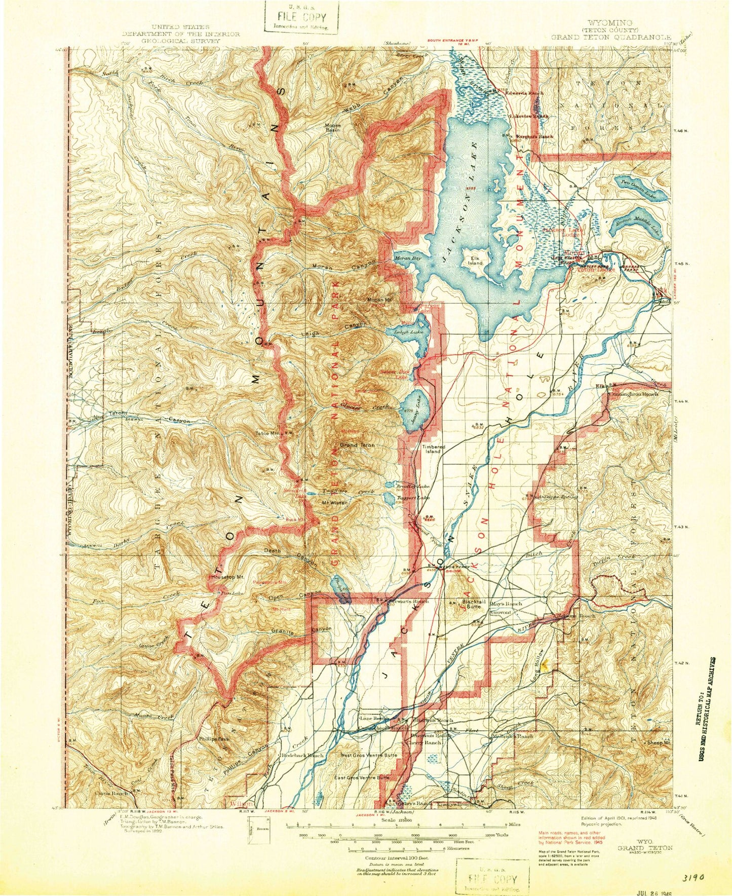
Historic 1901 Grand Teton Wyoming 30'x30' Topo Map
Couldn't load pickup availability
Historical USGS topographic map of Grand Teton in the state of Wyoming. Scale: 1:125000. Print size: 17" x 24"
This map was published in 1901 and is in the following counties: Teton.
The map contains contour lines, roads, rivers, towns, streams, and lakes. Printed on high-quality waterproof paper with UV fade-resistant inks.
Contains the following named places: Arizona Island, Badger Island, Bar B C Ranch, Baseline Flat, Bearpaw Bay, Bearpaw Lake, Blacktail Ponds, Blacktail Ponds Overlook, Boulder Island, Bradley Lake Trail, Burned Wagon Gulch, Cathedral Group Scenic Turnout, Colter Bay Village, Columbine Cascade, Cottonwood Creek, Cottonwood Creek Turnout, Cow Island, Cunningham Cabin, Deadman Point, Dollar Island, Elk Island, Glacier Gulch Turnout, Glacier View Turnout, Grassy Island, Half Moon Bay, Heron Pond, Hidden Falls Horse Trail, Indian Island, Inspiration Point, Jenny Lake, Jenny Lake Campground, Jenny Lake Lodge, Jenny Lake Moraine Horse Trail, Jenny Lake Trail, Laurel Lake, Leeks Lodge, Little Mackinaw Bay, Lupine Meadows, Marie Island, Moose, Moose Island, Moose Pond, Mount Moran Scenic Turnout, Mystic Isle, North Bar Bay, North Moran Bay, Paintbrush Canyon Trail, Pelican Bay, Mount Reid, Ribbon Cascade, Rock Face, Sargents Bay, Sheffield Island, South Bar, Spalding Bay, Spearhead Peak, String Lake Trail, Taggart Lake Trail, Teton Point Turnout, Timbered Island, Trapper Lake, Valley Trail, Watkins Ditch, Wilcox Point, Windy Point Turnout, Hermitage Point, Grovont, Albright Peak, Stewart Draw, Mount Bannon, Burnt Ridge, Glacier Creek, Hidden Falls, Eagles Rest Peak, Ramshead Lake, The Wedge, Beaver Creek, Moose Junction, North Jenny Lake Junction, South Jenny Lake Junction, Grand Teton National Park, The Wedge, Alaska Basin, Alaska Basin Trail, Alaska Basin Trail, Amphitheater Lake, Amphitheater Lake Trail, Andy Stone Creek, Andy Stone Trail, Antelope Flats, Apres Vous Peak, Arizona Creek, Arizona Lake, Arrowhead Pool, Atherton Creek, Atherton Creek Campground, Avalanche Canyon, Bailey Creek, Bannock Falls, Basin Lakes, Battleship Mountain, Bear Canyon, Beard Mountain, Beaver Creek, Beaver Creek Trail, Berry Creek, Bierer Creek, Bivouac Peak, Blacktail Butte, Blue Miner Lake, Bradley Lake, Broken Falls, Buffalo Fork, Camp Lake, Carpenter Draw, Cascade Canyon, Cascade Canyon Trail, Cascade Creek, Cascade Ranger Station, Christian Creek, Cirque Lake, Cleaver Peak, Cleft Falls, Cloudveil Dome, Coal Creek, Coal Creek Campground, Coal Creek Meadows, Colter Canyon, Coyote Lake, Crows Nest, Curtis Canyon, Curtis Canyon Campground, Curtis Canyon Overlook, Cygnet Pond, Darby Girls Camp, Deadmans Bar, Death Canyon, Death Canyon Shelf, Delta Lake, Devils Stairs, Disappointment Peak, Ditch Creek, Doane Peak, Dry Creek Basin, Dry Hollow, Dry Ridge Mountain, East Fork Pilgrim Creek, East Horn, East Prong, Eddington Canyon, Teton Science School, Elk Exhibition Pasture, Elk Mountain, Emma Matilda Lake, Emma Matilda Lake Trail, Falling Ice Glacier, Flat Creek Ranch, Forget-me-not Lakes, Fossil Mountain, Fox Creek Pass, Freds Mountain, Game Creek Trail, Garnet Canyon, Glacier Falls, Glacier Gulch, Mount Glory, Grand Targhee Resort, Granite Basin, Granite Basin Lakes, Granite Canyon, Granite Canyon Trail, Granite Creek, Green Lake, Green Lakes Mountain, Green Mountain, Green Mountain Trail, Grizzly Bear Lake, Gros Ventre Campground, Gros Ventre Junction, Gros Ventre River, Gros Ventre Slide Geological Area, Hanging Canyon, Hermitage Point Trail, Holly Lake, Housetop Mountain, Mount Hunt, Hurricane Pass, I W W Creek, Ice Point, Icefloe Lake, Indian Lake, J Y Ranch, Jackson Hole Ski Area, Jackson Lake Lodge, Jackson National Fish Hatchery, Mount Jedediah Smith, Jensen Canyon, Kit Lake, Lake Creek, Lake of the Crags, Lake Solitude Trail, Leigh Canyon, Littles Peak, Long Hollow, Lost Creek, Lost Creek Ranch, Lower Slide Lake, Lunch Tree Hill, Maidenform Peak, Mail Cabin Creek, Marion Lake, Mount Meek, Mesquite Creek, Mica Lake, Middle Fork Cut Off Trail, Middle Fork Ditch Creek, Middle Fork Granite Creek, Middle Fork Phillips Canyon, Middle Teton, Middle Teton Glacier, Miles Creek, Mill Creek, Millers Butte, Mink Lake, Moose Basin, Moose Basin Divide, Moose Creek, Moose Lake, Moose Meadows, Moose Mountain, Moose Mountain Slide, Moran Canyon, Moran Creek, Mount Moran, Mount Hunt Divide, Mount Meek Pass