MyTopo
Historic 1908 Grants Pass Oregon 30'x30' Topo Map
Couldn't load pickup availability
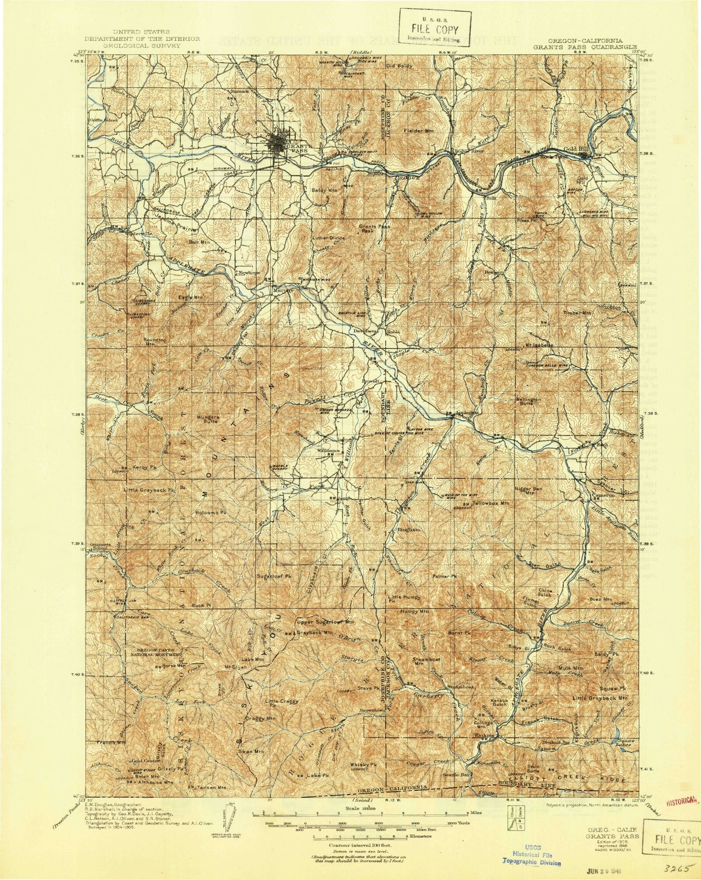
Historical USGS topographic map of Grants Pass in the state of Oregon. Scale: 1:125000. Print size: 17" x 24"
This map was published in 1908 and is in the following counties: Jackson, Josephine, Siskiyou.
The map contains contour lines, roads, rivers, towns, streams, and lakes. Printed on high-quality waterproof paper with UV fade-resistant inks.
Contains the following named places: Mallard Gulch, Bee Flat, Elliott Creek, Low Gap Trail, Steve Fork Trail, Thompson Ridge, Mulligan Bay, Mingo Gap, Hanley Gap, Buck Gulch, Jackson Recreation Site, Placer Recreation Site, Flumet Flat Recreation Site, Ash Flat, Jay Bird Mine, Applegate, Bill Nye Mine, Billy Mountain, Birdseye Creek, Blackwell Creek, Blackwell Hill, Braden Mine, Caris Creek, Fielder Creek, Fielder Mountain, Foots Creek, French Gulch, Galls Creek, Gold Hill, Humbug Creek, Mount Isabelle, Kane Creek, Ben Hur Lampman State Park, Left Fork Fielder Creek, Left Fork Foots Creek, Left Fork Sardine Creek, Little Savage Creek, Middle Fork Foots Creek, Millers Gulch, Miners Creek, Missouri Flat, Mountain Lion Mine, Old Baldy, Old Blue Mountain, Oregon Belle Creek, Oregon Belle Mine, Owl Hollow Mine, Panther Gulch, Provolt, Right Fork Fielder Creek, Right Fork Foots Creek, Right Fork Sardine Creek, Rock Creek, Rock Point, Rocky Creek, Sams Creek, Sams Valley, Sardine Creek, Savage Rapids, Schieffelin Gulch, Slagle Creek, Star Mine, Sturgis Mine, Sugarloaf, Timber Mountain, Tinpan Mine, Trimble Creek, Ward Creek, Wellington Butte, Whisky Gulch, Williams Guard Station, Smith Reservoir, Lucy Gulch, McCollum Reservoir, Magerly Reservoir, Spring Gulch, Del Rio Reservoir, East Fork Kane Creek, China Gulch, Jacksonville Dam, Jacksonville Reservoir, Bear Gulch, Alder Gulch, Lonesome Gulch, Rocky Creek, Water Gulch, Hence Creek, Oak Gulch, Maple Creek, White Spring Branch, Sugarpine Gulch, Maple Gulch, Cardwell Creek, Spanish Gulch, Hog Eye Creek, Gillet Gulch, Taylor Gulch, Moore Gulch, Left Fork Birdseye, East Branch Galls Creek, West Branch Galls Creek, Max Gulch, Horn Gulch, Brushy Gulch, Lyons Gulch, Lucky Boy Mine, Winningham Reservoir, George Black Gulch, Rock Gulch, Right Fork Forest Creek, Cantrall Creek, Long Gulch, Balls Branch, Kane Gulch, Left Fork Kidney Gulch, Kidney Gulch, Bailey Gulch, Cove Creek, Myrtle Gulch, Wooldridge Creek, Gold Hill Regional Park, Werner Dam, Boswell Mine, Rabbit Lake, Paradise Mine Number 1, Mountain View Mine, Kendall Cabin, Steamboat Ranch, Baker Flat, Buckhorn Gulch, Jackass Creek, Iron Gulch, Blanket Ledge Mine, Gypsy Queen Mine, Snow Bird Mine, Fish Hatchery County Park, Joe Gulch, Brown Res, Jamison Creek, Ruch Gulch, Ninemile Peak, Jim Mee Peak, No Name Creek, Bear Wallow Creek, Cinnabar Mountain, McKee Bridge, Palmer Ridge, Matney Gulch, O'Brien Gulch, Lilly Prairie, Lennox Gulch, Norling Gulch, Marshall Gulch, Miller Mountain, Sailor Gulch, Rail Gulch, Baldy Mountain, Bunny Meadows, South Highline Canal, South Main Canal, Gold Hill Irrigation District Canal, Evans Creek Lateral, Tokay Canal, Boyd Creek, South Fork Trimble Creek, Seaman Bar, Fall Creek, Bee Creek, Foots Creek, Reservoir Gulch, Valley of the Rogue State Park, Bear Gulch, Little Bald Spot, Big Bald Spot, Owl Hollow, Shasta Mine, Cold Springs Creek, Cold Springs Reservoir, Miller Mine, Eads Gulch, Watts and Topping Ditch, Bridgepoint Ditch, Johnsons Gulch, Cook Cove, New Berryman Ditch, Left Fork Balls Branch, Dunlap Reservoir, Graves Reservoir, Ferber Reservoir, Cedar Pond, Kings Reservoir, Katzenbach Reservoir, Fiddlers Gulch, Maple Springs Gulch, Holzhauser Reservoir, Remey Reservoir, Miller Reservoir, Trader Reservoir, Sunflower Gulch, Stone Sumps, FS Reservoir, Jones Marble Quarry, Red Rose Mine, Steppe Reservoir, Robertson Bridge County Park, Griffin County Park, Klose Pond, Lathrop County Park, Jerome Prairie Lateral, Daily Reservoir, Chapin Creek, Wee Bonnie Loch Glen Reservoir, The Drain, Sparrowhawk Creek, Apple Rogue Reservoir, Sylvanite Mine, Lyman Mine, Kane Creek, Kell Mine, Jorden Creek, Gold Nugget County Recreation Area, Dillon Falls, Hardy Riffle, Granger Reservoir, Harris Gulch, Vincent Reservoirs, Wiwona Reservoir, Colvig Gulch, Estramado Reservoir, Gold Gulch, Little Giant Mine, Anderson Mine, Molly Mine, Pikes Peak, Dry Creek, Lawnridge Park