MyTopo
Historic 1893 Great Bend Kansas 30'x30' Topo Map
Couldn't load pickup availability
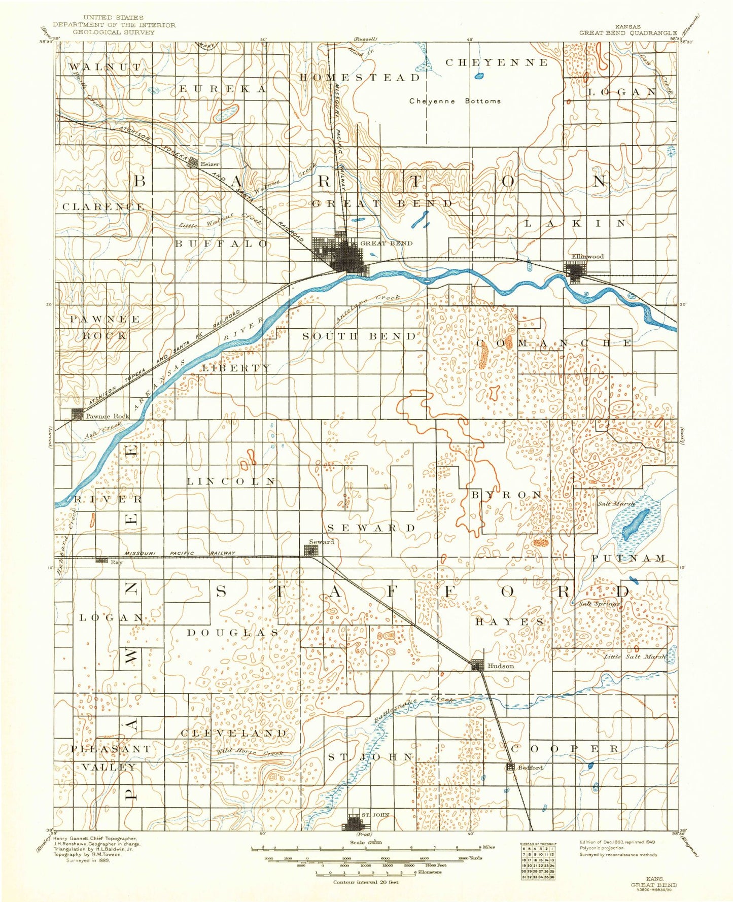
Historical USGS topographic map of Great Bend in the state of Kansas. Scale: 1:125000. Print size: 17" x 24"
This map was published in 1893 and is in the following counties: Barton, Pawnee, Stafford.
The map contains contour lines, roads, rivers, towns, streams, and lakes. Printed on high-quality waterproof paper with UV fade-resistant inks.
Contains the following named places: Little Wild Horse Creek, Bear Creek, St. John, Township of St. John, Township of West Cooper, Township of East Cooper, Blood Creek, Township of South Homestead, Cheyenne Bottoms, Cheyenne Bottoms Wildlife Area, Township of Logan, Dry Walnut Creek, Township of Clarence, Township of Walnut, Boot Creek, Heizer, Township of Buffalo, Township of Eureka, Koen Canal, Barton Lake, Great Bend, Township of Great Bend, Township of Lakin, Walnut Creek, North Branch Sharps Creek, North Fork Little Arkansas River, Ash Creek, Township of River, Township of Pawnee Rock, Township of Lincoln, Township of Liberty, Dundee, Pawnee Rock State Park, Antelope Creek, Township of South Bend, Township of Byron, Township of Comanche, Bellville School, Fort Zarah Park, Township of Putnam, Ellinwood, Pickle Creek, Township of Logan, Radium Townsite Oil Field, Radium, Bayer Oil Field, Dunes North Oil Field, Township of South Seward, Seward, Township of Hayes, Quivira National Wildlife Refuge, Rattlesnake Canal, West Canal, Big Salt Marsh, Rattlesnake Creek, Township of Cleveland, Township of Valley Center, James Lake, Eppley Lake, Gilmore Lake, Hudson, Wild Horse Creek, Great Bend Prairie, Barton County Fairgrounds, Dent Spur, Westgate Shopping Center, Village Mall, Great Bend Plaza, Bedford, Anchorway, Brit Spaugh Park, Heizer Park, Veterans Memorial Park, Dartmouth, Ray, Kanbrick, Pawnee Rock, Barton County, Stafford County, Township of Douglas, City of Ellinwood, City of Great Bend, Township of North Seward, City of Hudson, City of Pawnee Rock, City of Radium, City of St. John, City of Seward, Ellinwood Wastewater Plant, St. John Sewer Treatment Plant, Barton County Landfill, Great Bend Zoo, Sunflower Rod and Custom Association Dragstrip, Wetlands at Great Bend Aquatic Facility, Barton County Community College Water Treatment Facility, Great Bend Water Treatment Facility, Pawnee Rock Water Treatment Facility, Hudson Wastewater Plant, Finer Mobile Home Park, South Side Mobile Court, Village Mobile Home Park, Grove Park Golf Course, Stoneridge Golf Club, Lake Barton Golf Course, Great Bend Co - Operative Association Grain Elevator Number 5, Stafford County Flour Mills Grain Elevator Number 1, Great Bend Co - Operative Association Grain Elevator Number 1, Great Bend Co - Operative Association Grain Elevator Number 2, Great Bend Co - Operative Association Grain Elevator Number 3, Great Bend Co - Operative Association Grain Elevator Number 4, Great Bend Co - Operative Association Grain Elevator Number 5, Pool 1B, Pool 1A, Pool 1C, Pool 2, Pool 3A, Pool 3B, Pool 4A, Pool 4B, Pool 5