MyTopo
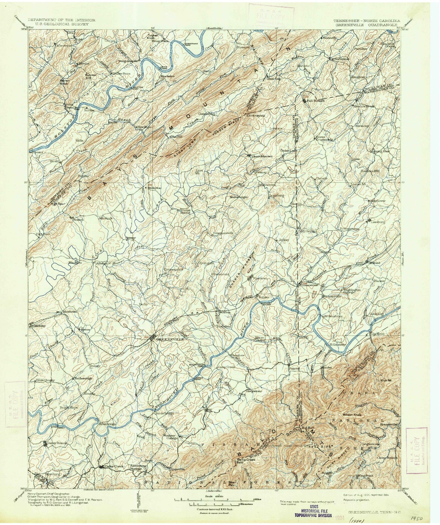
Historic 1904 Greenville Tennessee 30'x30' Topo Map
Couldn't load pickup availability
Historical USGS topographic map of Greenville in the state of Tennessee. Scale: 1:125000. Print size: 17" x 24"
This map was published in 1904 and is in the following counties: Cocke, Greene, Hawkins, Madison, Sullivan, Unicoi, Washington.
The map contains contour lines, roads, rivers, towns, streams, and lakes. Printed on high-quality waterproof paper with UV fade-resistant inks.
Contains the following named places: Bearwallow Gap, Big Butt, Blackstack Cliffs, Camp Creek Bald, Green Ridge, Seng Ridge, Trail of the Lonesome Pine, Bald Mountain, Big Firescald Knob, Chestnutlog Gap, Flint Mountain, Gravel Knob, Little Bald Mountain, Little Firescald Knob, Andrew Johnson Mountain, Grassy Mountain, Brown Branch, Brown Mountain, Camp Creek, Caney Creek, Caney Ridge, Davy Crockett Lake, Dodd Creek, Easley Ridge, Fall Branch, Grassy Valley, Hoover Creek, Little Limestone Creek, Miller Ridge, Piney Mountain, Piney Mountain, Shed Ridge, Shelton Branch, Short Mountain, Short Mountain, Short Mountain, Short Mountain, Sill Branch, Simmons Branch, Simpson Creek, Simpson Island, Skipper Ridge, Slide, Slipper Spur Gap, Smith Gap, Snapp Branch, Snow Camp Branch, Solomon Branch, South Fork Roaring Fork, South Fork Sill Branch, Splatter Creek, Stage Creek, Staunton Mill, Stinking Creek, Stony Cove, Stony Lump, Stony Point Creek, Striggersville, Sugar Hollow, Sugar Hollow, Sugar Tree Hollow, Sullivan Gardens, Sulphur Spring Branch, Sulphur Spring Branch, Sulphur Springs, Summersville, Susong Island, Swift Hollow, Tadpole Hollow, Taughn Hollow, Taylor Knob, Taylor Knob, Taylor Ridge, Terrill Creek, The Doubles, Tilson Hollow, Tipton Creek, Town Acres, Tucker Hollow, Tucker Hollow, Tucker Knob, Tusculum, Ugly Hollow, Unaka View, Union Temple, Union Temple Creek, Vernon Heights, Walkertown Branch, Walter Crossroad, War Gap, War Valley, Washboard Creek, Washington College Post Office and Station, Wattenbarger Branch, Wattenbarger Gap, Webster Valley, West Fork Caney Creek, Wheelock Hollow, Wickham Hollow, Wildcat Branch, Wire Knob, Wolf Branch, Wolf Gap, Wolf Pen Gap, Woolsey Gap, Yarbrough Cliff, Yellow Store, Young Branch, Zion Hill, Zion Hill, Bright Branch, Alec Mountain, Allegheny Ridge, Asbury Creek, Babb Creek, Babbs Knob, Babbs Valley, Back Creek, Back Hollow, Baileyton, Baines Ridge, Bald Hill, Bald Hill, Bales Creek, Baskett Ridge, Bayless Bluff, Bear Creek, Bear Hollow, Bear Hollow, Bear Hollow, Bear Hollow, Beech Creek, Bell Hollow, Bernard Hollow, Berry Pond, Big Branch, Big Double Branch, Big Hollow, Big Mountain, Big Ridge, Big Ridge, Big Ridge, Bird Branch, Bird Island, Birdwell Pond, Birdwell Ridge, Blackley Creek, Blair Gap Branch, Blue Springs Branch, Bluff Mountain, Bone Valley, Bowmantown, Bowmantown Ridge, Bowser Ridge, Bradburn Hill, Bradley Creek, Brokenback Mountain, Brushy Mountain, Buffalo Creek, Bunker Hill, Burkey Pond, Butcher Valley, Butcher Valley Creek, Campbell Gap, Campbell Knobs, Campbell Ridge, Cane Island, Canebrake Mountain, Caney Branch, Cannon Knob, Carl Thorpe Hollow, Carson Creek, Carter Valley, Cave Ridge, Cedar Creek, Cedar Creek, Cedar Lane, Centersville, Chalk Level, Charles Mountain, Cheroy Hill, Chestnut Ridge, Chestnut Ridge, Chimneytop Mountain, Cinder Hill, Clear Creek, Clear Creek Mill, Clear Fork, Clearwater Pond, Coal Gap, Cochran Bend, College Creek, Colonial Heights, Combs Pond, Cooter Hollow, County Line Gap, Cove Branch, Cove Creek Mill, Cove Gap, Cove Mountain, Cove Mountain, Cox Hollow, Cox Island, Cox Ridge, Crabtree Branch, Crabtree Hollow, Crazy Creek, Cruickshank Knob, Cuerton Dial Branch, Cup Hollow, Cutshaw Gap, Dark Hollow, Dark Hollow, Dark Hollow, Davis Branch, DeRusk, Deacon Ridge, Devil Branch, Devils Elbow, Devils Kitchen Branch, Dice Ridge, Diehl Hollow, Dixon Hollow, Dodd Branch, Dodson Creek, Dodson Hollow, Dodson Mountain, Dolan Branch, Dosser Ridge, Doty Creek, Doty Ridge, Double Lick Branch, Double Springs Ridge, Douglas Shed, Douglas Shed Ridge, Dry Branch