
MyTopo
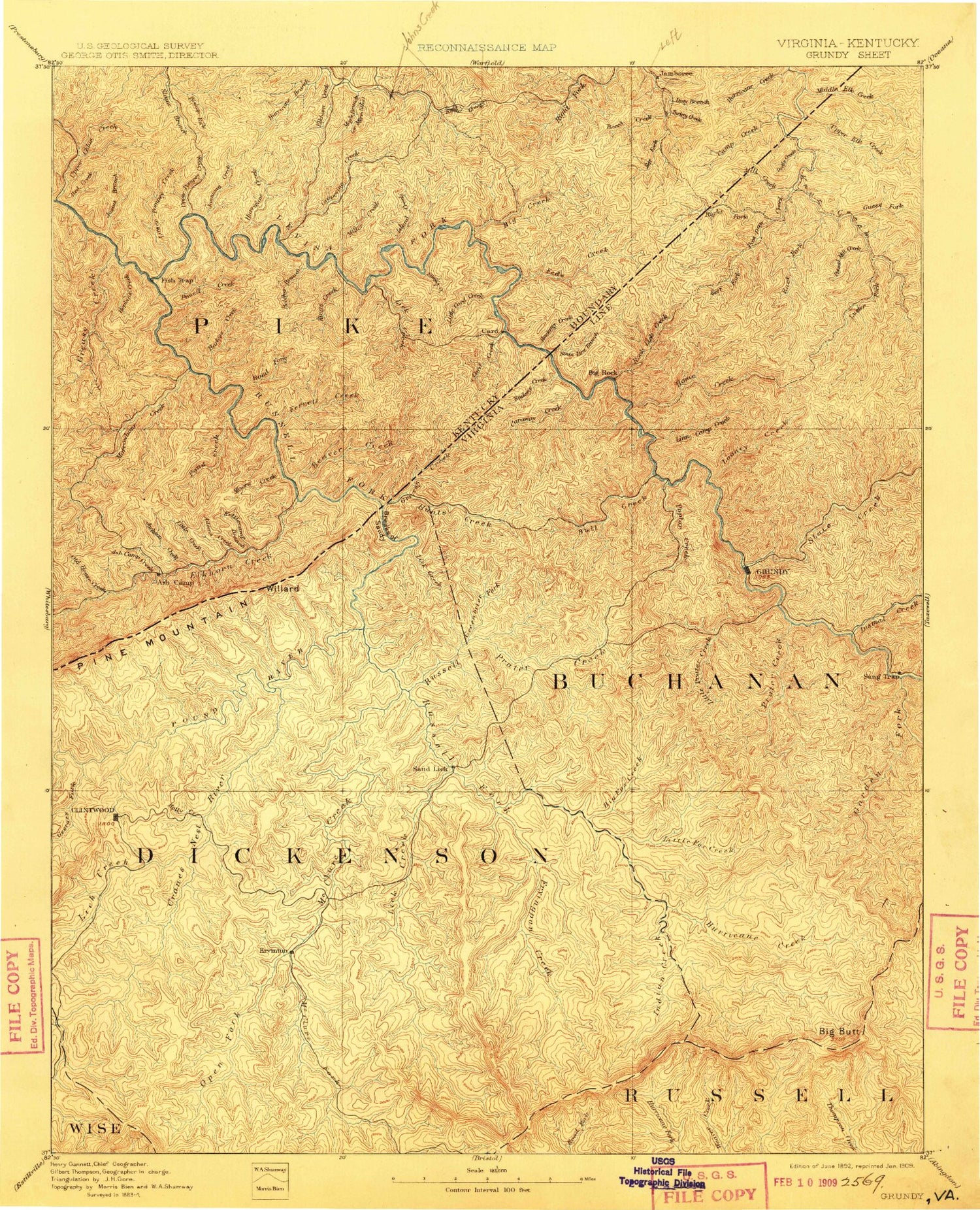
Historic 1892 Grundy Virginia 30'x30' Topo Map
Couldn't load pickup availability
Historical USGS topographic map of Grundy in the state of Virginia. Scale: 1:125000. Print size: 16" x 24"
This map was published in 1892 and is in the following counties: Buchanan, Dickenson, Pike, Russell, Wise.
The map contains contour lines, roads, rivers, towns, streams, and lakes. Printed on high-quality waterproof paper with UV fade-resistant inks.
Contains the following named places: Birch Gap, Blowing Rock Gap, Devils Branch, Dilse Branch, Dutton Gap, Flat Gap, Grassy Creek, Grassy Gap, Hackney Creek, Jesse Gap, Little Grassy Branch, Locust Thicket, Middle Elk Creek, Mill Creek, Old House Fork, Pawpaw Creek, Piney Fork, Rockhouse Fork, Russell Fork, Skeet Rock Knob, Skegg Gap, Skegg Knob, Swan Fork, Upper Elk Creek, Ivy Lick, McClure Creek, Patton Branch, Three Forks, Abner Branch, Abner Gap, Abners Fork, Adkins Ridge, Adkins Trace, Alleys Creek, Anderson Branch, Andy Branch, Arwood Hollow, Austin Gap Branch, Bad Branch, Bad Ridge, Baldwin Branch, Baldwin Branch, Ball Creek, Ball Ridge, Ball Ridge, Balls Fork, Barton Fork, Bear Branch, Bear Branch, Bear Branch, Bear Fork, Bear Hollow, Bear Hollow, Bear Hollow, Bear Ridge, Bear Wallow, Bearwallow Branch, Beech Branch, Belcher Branch, Belcher Fork, Benns Branch, Bens Branch, Berry Hollow, Big A Mountain, Big Branch, Big Branch, Big Branch, Big Branch, Big Branch, Big Branch, Big Cedar Branch, Big Fork, Big Hollow, Big Hollow, Big Lick Branch, Big Log Branch, Big Prater Creek, Big Rock Branch, Big Spraddle Branch, Big Spruce Pine Branch, Bill Branch, Bill Deel Branch, Bill Ridge, Billy Fork, Bise Ridge, Blair Branch, Booth Branch, Bowen Gap, Box Branch, Box Camp Creek, Boyd Branch, Boyd Fork, Boyd Ridge, Boyd Ridge, Bradley Gap, Brakes Fork, Breeden Branch, Breeden Branch, Brierfield Branch, Brushy Fork, Brushy Ridge, Bubby Branch, Buchanan Ridge, Buck Branch, Buckeye Branch, Buffalo Creek, Buffalo Fork, Buffalo Tunnel, Bull Creek, Bull Gap, Burnt Poplar Fork, Butcherknife Fork, Cabin Branch, Cabin Fork, Cabin Ridge, Call Fat Branch, Camp Branch, Canaway Creek, Cane Creek, Cane Gap, Caney Fork, Caney Island Branch, Caney Tunnel, Carico Ridge, Carver Branch, Cedar Branch, Childress Creek, Cindy Fork, Claypool Branch, Clear Fork Branch, Coleman Branch, Combs Ridge, Conaway Gap, Convict Hollow, Cook Fork, Coon Branch, Coon Flat Branch, Copper Mine Branch, Copperhead Branch, Copperhead Gap, Counts Ridge, Cove Hollow, Cove Hollow, Cox Branch, Crackers Neck, Cranenest Branch, Cripple Creek, Crooked Branch, Crooked Branch, Crooked Branch, Crooked Fork, Dark Hollow, Dark Hollow, Dark Hollow, Dave Branch, Davis Ridge, Deadening Branch, Deadman Hollow, Deel Branch, Deel Branch, Deel Fork, Devil Branch, Dick Branch, Dicks Branch, Dingus Gap, Dismal Creek, Dismal Fork, Ditch Hollow, Dog Branch Gap, Dog Fork, Dogpen Branch, Dooley Hollow, Dry Fork, Dry Hollow, Elijah Branch, Elkins Branch, Elm Root Hollow, Elswick Fork, Enochs Branch, Farrell Branch, Feds Camp Branch, Flat Gap, Flat Spur, Fletcher Branch, Fletcher Ridge, Fletcher Ridge, Flint Gap, Fox Creek, Frogpond Ridge, Fuller Branch, Garden Creek, Gent Branch, George Hollow, Gibson Branch, Gilbert Fork, Grape Branch, Grassy Spring Branch, Grave Hollow, Graveyard Hollow, Greenbriar Branch, Greenbrier Creek, Little Greenbrier Creek, Grissom Creek, Grizzle Hollow, Guess Fork, Hackney Hollow, Hairpin Branch, Hale Hollow, Halfmile Branch, Halls Branch, Hannah Gap, Happy Branch, Hardin Branch, Harm Ridge, Harper Branch, Harper Creek, Hart Creek, Hatchet Branch, Hibbitts Gap, Hobbs Branch, Hollow Poplar Branch, Home Creek, Honey Branch, Hoot Owl Gap, Horse Branch, Horse Branch, Horseshoe Branch, Horseshoe Branch, Huffman Fork, Hunts Fork, Hurricane Creek, Hurricane Fork, Indian Creek, Indian Grave Branch, Indian Grave Gap, Issac Branch


