MyTopo
Historic 1905 Guadalupe California 30'x30' Topo Map
Couldn't load pickup availability
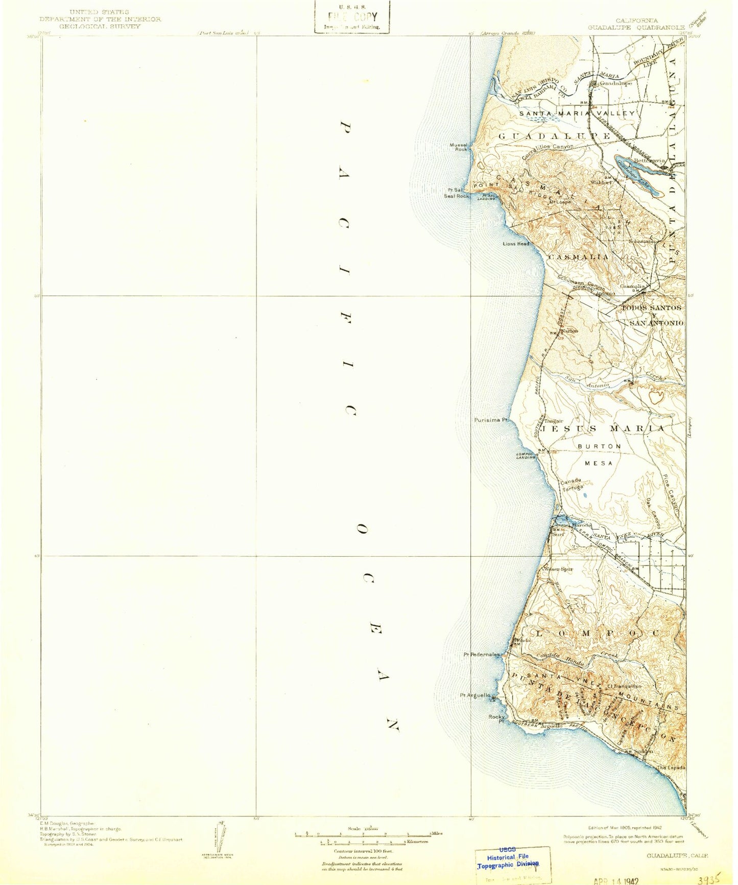
Historical USGS topographic map of Guadalupe in the state of California. Scale: 1:125000. Print size: 17" x 24"
This map was published in 1905 and is in the following counties: San Luis Obispo, Santa Barbara.
The map contains contour lines, roads, rivers, towns, streams, and lakes. Printed on high-quality waterproof paper with UV fade-resistant inks.
Contains the following named places: Afrox Mine, Bear Creek, Betteravia Storage, Canada De Los Ladrones, Canada De Los Sauces, Canada Del Jolloru, Canada Del Morida, Canada Del Rodeo, Canada Honda Creek, Canada Tortuga, Carr Scale, Casmalia, Casmalia, Casmalia Canyon, Corralitos Ranch, Cypress Ridge, Espada Bluff, Grey Canyon, Guadalupe, Jalama Creek, Jesus Maria, La Honda Canyon, La Salle Canyon, Lake Canyon, Le Roy Park, Lions Head, Lompoc, Lompoc Canyon, Lompoc Terrace, Long Horn Canyon, Marshallia Ranch, Mussel Point, N T U Mine, Oak Canyon, Oak Mountain, Ocean Beach Park, Oil Well Canyon, Orcutt Creek, Pine Canyon, Point Arguello, Point Pedernales, Point Sal, Point Sal State Beach, Point Sal Ridge, Post, Promontory, Punta De La Concepcion, Purisima Point, Red Roof Canyon, Rocky Point, San Antonio Valley, Santa Lucia Canyon, Santa Maria River, Santa Ynez River, Sloans Canyon, Spring Canyon, Sudden, Sudden Canyon, Sudden Flats, Sudden Peak, Surf, The Espada, Tranquillon Ridge, Water Canyon, Wild Horse Flat, Baroda, Barsug, Carr, Iremel, La Salle, Narlon, Tangair, Port Petrol, North Point, San Antonio Terrace, Shuman, Shuman Canyon, Canada Agua Viva, Corralitos Canyon, Lion Rock, Mussel Rock, Tranquillon Mountain, Jalama Beach County Park, Santa Maria Valley, Casmalia Oil Field, Guadalupe Oil Field, Guadalupe, Betteravia Stockyards, San Antonio Creek, Antonio, Casmalia Hills, Devon, Arguello, Arlight, Betteravia, Betteravia Junction, Bragur, Burton Mesa, Destroyer Rock, Gum, Honda, Lompoc Landing, Mount Lospe, Round Hill, Waldorf, Wild Horse Peak, Mussel Rock Dunes, Seal Rock, Guadalupe Lake, Point Arguello Lighthouse, Guadalupe Division, City of Guadalupe, La Salle Stables, San Ysidro Farms