MyTopo
Historic 1901 Gurdon Arkansas 30'x30' Topo Map
Couldn't load pickup availability
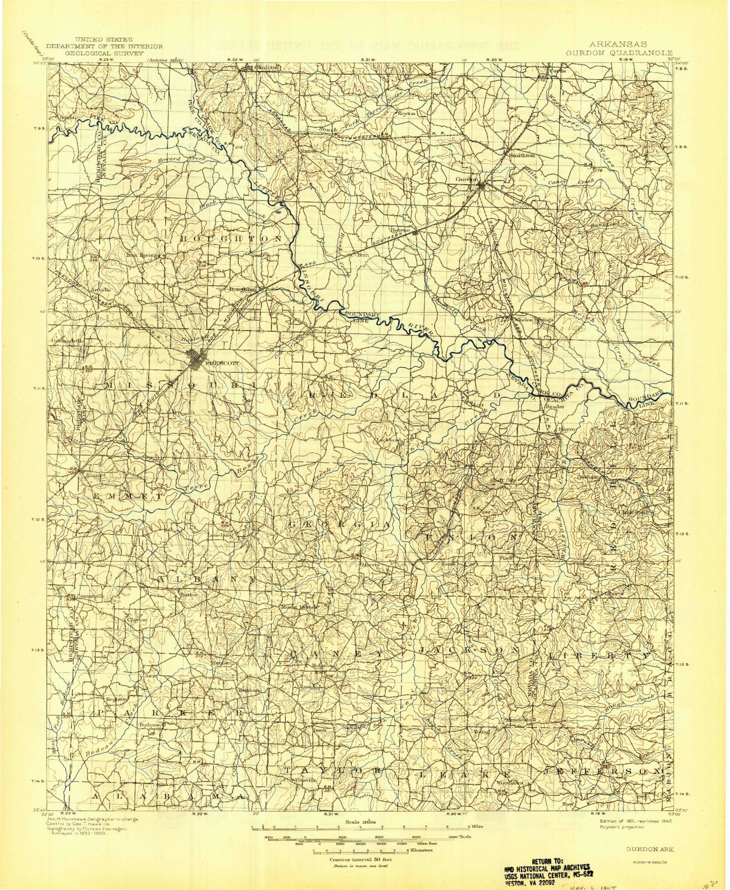
Historical USGS topographic map of Gurdon in the state of Arkansas. Scale: 1:125000. Print size: 18" x 24"
This map was published in 1901 and is in the following counties: Clark, Hempstead, Nevada, Ouachita, Pike.
The map contains contour lines, roads, rivers, towns, streams, and lakes. Printed on high-quality waterproof paper with UV fade-resistant inks.
Contains the following named places: Allen Branch, Anthony Switch, Arnold Creek, Ball Branch, Bankhead Creek, Barbaree Branch, Barham Branch, Barham Branch, Bear Creek, Beaver Slough, Bee Branch, Beech Branch, Beech Creek, Black Branch, Black Branch, Black Creek, Bluff City, Bolin Slough, Boughton, Brushy Creek, Brushy Creek, Brushy Creek, Brushy Creek, Buffalo Creek, Bull Branch, Bull Mountain, Burdell Branch, Caney Creek, Caney Creek, Caney Creek, Cantley Branch, Caruse Creek, Center Point, Clark Branch, Coffee Creek, Copeland Ridge Branch, Copeland Ridge Community Hall, Cox Creek, Cypress Brake, Cypress Creek, Deep Slough, Dry Branch, Dry Branch, Dry Fork, East Troy Oil Field, Emmet, Flat Branch, Garland Creek, Garland Creek, Garner Creek, Gores Peak, Grand Branch, Gum Creek, Gurdon, Half Moon Slough, Hamm Branch, Henley Branch, Hill Slough, Hooper Branch, Horse Branch, Horseshoe Bend, Howard Creek, Lick Branch, Lick Creek, Lick Creek, Little Beech Branch, Little Caney Creek, Little Sandy Creek, Little Terre Rouge Creek, Locket Creek, Long Slough, May Creek, McNeeley Creek, McRae Park, Meadows Branch, Middle Caney Creek, Middle Creek, Mill Branch, Mill Branch, Mill Creek, Minnie Slough, Moore Creek, North Boat Ditch, Number One Bayou, Okolona, Onion Creek, Owens Branch, Panther Branch, Pate Creek, Pine Branch, Pine Creek, Poison Springs State Forest, Prescott, Pruitt Creek, Rocky Branch, Rosston, Sandy Branch, Sandy Creek, Sandy Creek, Scrouge Creek, Smithton Branch, Steel Creek, Taylor Creek, Tidwell Branch, Tribble Creek, Tunnel Branch, Union Branch, Vickers Creek, Waggle Creek, Walters Bluff, West Fork Beech Creek, White Oak Creek, White Oak Creek, White Oak Lake State Park, Whiteside Creek, Whitten Branch, Williams Creek, Willisville, Wilson Creek, Winding Slough, Smithton, Arcadia, Azor, Barham, Bowen, Centerville, Cummings Springs, Garlandville, Harmony, Irma, Midway, Morris, Mount Moriah, Red Springs, Sayre, Waterloo, Ames, Barringer, Cale, Chidester, Curtis, Dills Mills, Gum Grove, Iron Springs, Mendenhall, Nevark, Oak Grove, Piney Grove, Pleasant Hill, Polk Stinnett Hill, Red Hill, Redland, Spring Hill, Sutton, Sycamore, Troy, Whetstone Mountain, Young, Poison Springs State Park, Township of Noland, Township of Albany, Township of Boughton, Township of Caney, Township of Emmet, Township of Georgia, Township of Jackson, Township of Leake, Township of Missouri, Township of Parker, Township of Redland, Township of Taylor, Township of Union, Township of Jefferson, Township of Liberty, Township of Red Hill, Nevada County, Antoine River, Deanyville, Grayson Pond, White Oak Lake, Grassy Lake, Horn Lake, Salt Lake, Suckles Lake, Beirne, Black Creek, Bodcaw, Bodcaw Oil Field, Boggy Creek, Burtsell, Good Hope, Goodson Creek, Irma Oil Field, Laneburg, Little Bodcau Creek, Reader, Sanders Creek, Sewer Creek, Terre Rouge Creek, Trammel Creek, Troy Oil Field, West Willisville Oil Field, Whelen Springs, White Oak Creek, Gurdon Pond Two Dam, Gurdon Pond Two, Gurdon Pond One Dam, Gurdon Pond One, Bee Bee Lake Dam, Bee Bee Lake, Hale Lake Dam, Hale Lake, Heathlake Dam, Heathlake Reservoir, Rosston Lake Dam, Rosston Lake, Barham Lake Number One Dam, Barham Lake Number 1, Barham Lake Number Two Dam, Barham Lake Number Two, Arkansas Noname 68 Dam, Arkansas Noname 68 Reservoir, Lower White Oak Lake Dam, Lower White Oak Lake, Upper White Oak Lake Dam, Upper White Oak Lake, Beavers Lake Dam, Beavers Lake, Pace Lake Dam, Pace Lake, Catfish Pond Dam, Catfish Pond, Rocky Mound Pond Dam, Rocky Mound Pond, Rolling Hills Pond Dam, Rolling Hills Pond