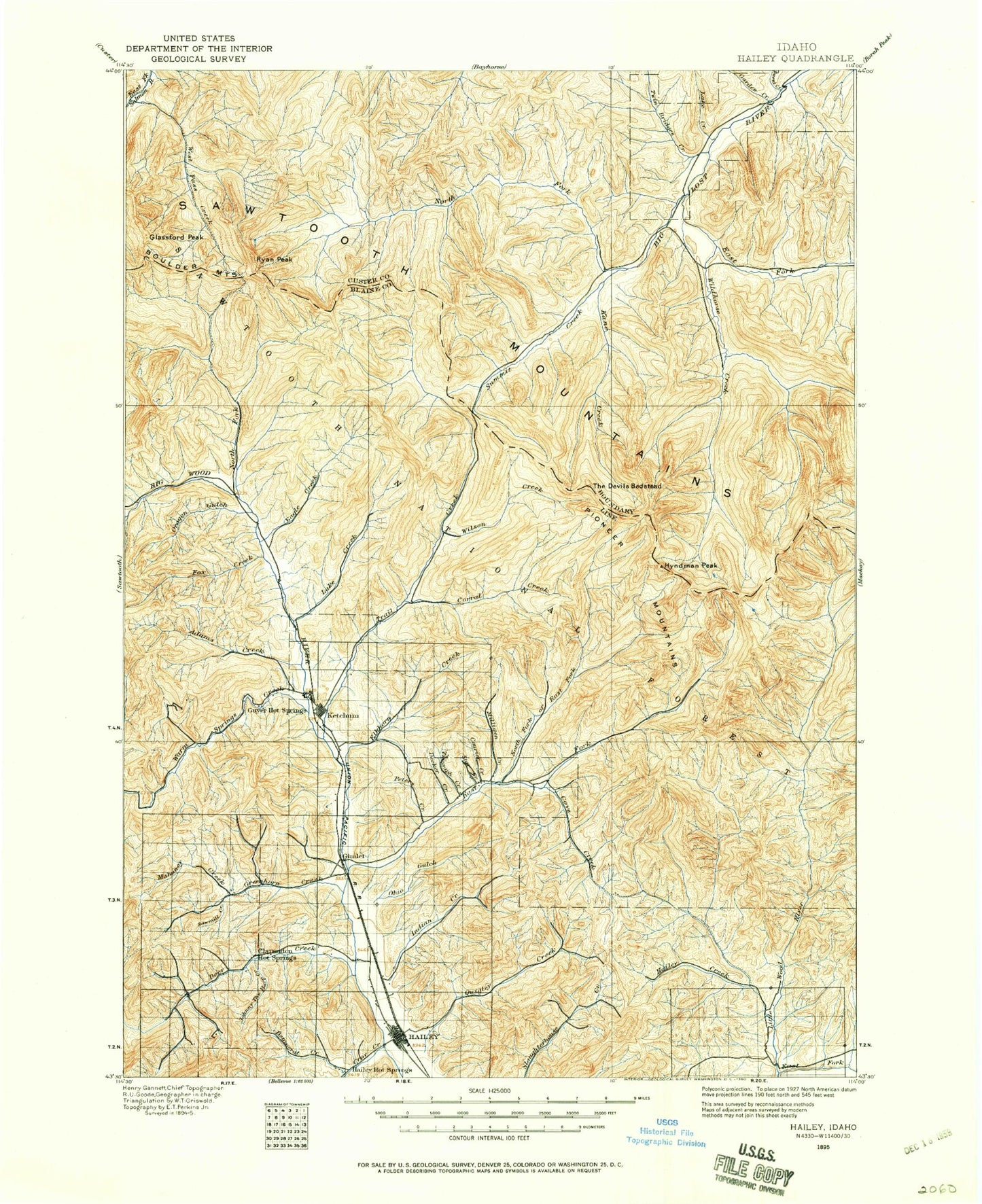
MyTopo
Historic 1895 Hailey Idaho 30'x30' Topo Map
Couldn't load pickup availability
Historical USGS topographic map of Hailey in the state of Idaho. Scale: 1:125000. Print size: 18" x 24"
This map was published in 1895 and is in the following counties: Blaine, Custer.
The map contains contour lines, roads, rivers, towns, streams, and lakes. Printed on high-quality waterproof paper with UV fade-resistant inks.
Contains the following named places: Cabin Creek, Carbonate Mountain, Cobb Peak, Cove Canal, Deadman Gulch, Deer Creek Ranch, Della Mountain, Fowler Gulch, Hangman Gulch, Hiawatha Canal, Indian Creek, Justus Ditch, Lambs Gulch, Mizer Ditch, Moran Creek, Ohio Gulch, Osborn Gulch, Pasture Creek, Quigley Creek, Quigley Pond, Red Devil Mountain, The Narrows, Vorberg Gulch, Patterson Peak, Grave Canyon, Pioneer Mountains, Alturas Gulch, Amber Gulch, Amber Lakes, Amicus Mine, Antelope Creek, Arrowhead Lake, Aspen Gulch, Badger Canyon, Bady Creek, Bailey Creek, Bald Mountain, Baptie Lake, Baron Gulch, Bartlett Creek, Basin Gulch, Bassett Gulch, Baugh Creek, Bear Creek, Bear Gulch, Bench Lake, Betty Lake, Big Basin, Big Fall Creek, Big Fall Creek Lake, Big Rocky Canyon, Big Witch Creek, Blind Canyon, Blind Creek, Boulder Creek, Boulder Creek, Boulder Lake, Boulder Mountains, Boundary Campground, Bowery Guard Station, Box Canyon, Bridge Campground, Brocky Canyon, Brown Creek, Buck Creek, Buckhorn Creek, Burks Creek, Burnt Aspen Creek, Burnt Creek, Button Creek, Cabin Gulch, Camp Manapu, Chaparral Creek, Chicken Creek, Chicken Creek, Clear Creek, Cold Canyon, Cold Spring Creek, Cold Spring Gulch, Comstock Ditch, Corral Canyon, Corral Canyon, Corral Creek, Corral Creek, Cottonwood Campground, Cougar Canyon, Courier Mine, Cove Creek, Cow Creek, Crooked Canyon, Croy Creek, Deadend Canyon, Deep Creek, Deer Creek, Deer Creek, Democrat Gulch, Democrat Mine, Dip Creek, Dollar Lake, Dollar Mountain, Driveway Gulch, Drop Canyon, Dry Canyon, Dry Canyon, Dry Canyon, Dry Draw, Duncan Ridge, Eagle Creek, East Fork Big Lost River, East Fork North Fork Big Wood River, Eve Gulch, Fall Creek, Federal Gulch, Federal Gulch Campground, Finley Gulch, Fisher Canyon, Fox Creek, Garden Creek, Glassford Peak, Goat Lake, Goat Creek, Grasshopper Creek, Grays Creek, Grays Peak, Greenhorn Creek, Greenhorn Gulch, Griffin Butte, Hailey Creek, Harry Canyon, Headquarters Canyon, Herd Peak, Hook Draw, Horse Creek, Hunter Creek, Hyndman Campground, Hyndman Peak, Imperial Gulch, Independence Gulch, Independence Mine, Iron Mine Creek, Jim Canyon, Johnstone Creek, Johnstone Pass, Johnstone Peak, Jolly Sailor Gulch, June Day Mine, Kale Creek, Kane Creek, Kane Lake, Kendall Gulch, Kent Peak, Keystone Gulch, Konrad Creek, Laidlaw Creek, Lake Creek, Lake Creek, Lake Creek Lakes, Lane Creek, Larkspur Gulch, LeMoyne Creek, Left Fork Fall Creek, Left Fork Wildhorse Creek, Leroux Creek, Limekiln Gulch, Little Basin, Little Burnt Creek, Little Fall Creek, Little Kane Creek, Lodgepole Gulch, Long Gulch, Long Gulch, Lost Mine Canyon, Lower Box Canyon Lake, Lucky Gulch Mine, Mahoney Butte, Mahoney Creek, Mandolin Creek, Mascot Mine, Meridian Peak, Miller Canyon, Montgomery Mine, Moonlight Gulch, Moose Lake, Morgan Ridge, Mud Creek, Mud Springs Creek, Murdock Campground, Murdock Creek, Narrow Gauge Gulch, Nay Aug Gulch, Neal Canyon, Newton Creek, North Fork Big Lost River, North Fork Big Wood River, North Fork Campground, North Fork Deer Creek, North Fork Hyndman Creek, North Fork Lake, North Star Mine, Old Hyndman Peak, Old Triumph Mine, Oregon Gulch, P K Pass, Painter Creek, Panther Gulch, Park Canyon, Park Creek, Park Creek Campground, Parker Mine, Paymaster Gulch, Penny Lake, Penny Mountain, Phi Kappa Campground, Phi Kappa Creek, Phi Kappa Mines, Phi Kappa Mountain, Pierce Tunnel, Pioneer Cabin, Pole Creek, Porcupine Creek, Pot Creek, Proctor Mountain, Prospect Hill, Prunty Creek, Pumphrey Canyon, Red Cloud Mine, Red Warrior Creek, Right Fork Kane Creek, Right Fork Fall Creek, Roaring Creek, Rock Roll Canyon, Ryan Peak, Saint Louis Mine, Sawmill Campground, Sawmill Creek, Sawmill Gulch