MyTopo
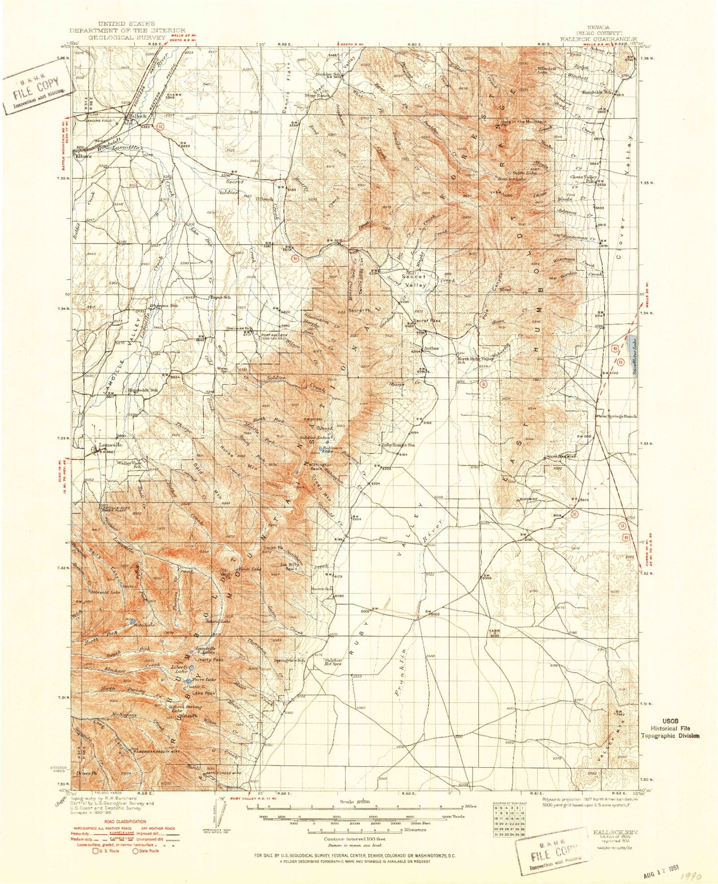
Historic 1935 Halleck Nevada 30'x30' Topo Map
Couldn't load pickup availability
Historical USGS topographic map of Halleck in the state of Nevada. Scale: 1:125000. Print size: 17" x 24"
This map was published in 1935 and is in the following counties: Elko.
The map contains contour lines, roads, rivers, towns, streams, and lakes. Printed on high-quality waterproof paper with UV fade-resistant inks.
Contains the following named places: Corral Canyon, Dennis Flats Pipeline, Poverty Gulch, South Branch Lamoille Creek, Valley Mountain, Halleck, Lone Butte, Halleck Station, Ruby Valley Reservoir Number One, Deer Horn Ranch, El Rancho, Glaser Ranch, Michigan Mine, Warm Creek Mining District, Dennis Flats, Seventyone Ranch, Ruby Valley Mining District, Cow Hollow, M J Dahl Ranch, Alles Creek, American Beauty Mine, Arthur, Bald Mountain, Battle Creek Mines, Baxter Creek, Big Meadow, Bills Fishpond, Birch Creek, Birdeye Lake, Boulder Lake, Camp Lamoille, Carter Creek, Castle Lake, Chase Creek, Chokecherry Creek, Cold Creek, Cold Lakes, Conrad Creek, Covert Creek, Dads Creek, Devils Slide Canyon, Dollar Lakes, Dorsey Creek, Drown Peak, Dry Creek, Dry Creek, East Fork Boulder Creek, East Humboldt Range, Echo Lake, Favre Lake, First Boulder Creek, Fort Halleck Historical Marker, Fourth Boulder Creek, Gedney Creek, Gardner Creek, Gordon Creek, Green Mountain, Griswold Creek, Griswold Lake, Heelfly Creek, Hidden Lakes, Hole in the Mountain, Hole in the Mountain Peak, Hoopers Dam, Horse Creek, Horse Mountain, Humboldt Peak, Island Lake, Joe Billy Basin, John Day Canyon, John Day Creek, Krenka Creek, Lake Peak, Lamoille, Lamoille Creek, Lamoille Lake, Lamoille Valley, Leach Creek, Lemons Creek, Liberty Lake, Liberty Pass, Little Thorpe Creek, Lizzies Basin, Lost Creek, Lutts Creek, Mahogany Creek, Middle Fork Cold Creek, Middle Fork Deering Creek, Mineral Spring Canyon, Mose Creek, Murphy Creek, North Fork Cold Creek, North Furlong Lake, North Ranch, Old Man of the Mountain, Poison Canyon, Pole Canyon, Rabbit Creek, Rattlesnake Canyon, Renshaw Creek, Right Fork Lamoille Creek, Robinson Creek, Robinson Lake, Rockwall Creek, Ross Creek, Ruby Dome, Ruby Valley Forest Service Station, Schoer Creek, Second Boulder Creek, Secret Creek, Secret Pass, Secret Peak, Secret Valley, Segunda Creek, Seitz Lake, Shady Creek, Sharps Creek, Shorty Creek, Signal Hill, Smith Creek, Smith Peak, Snake Hollow, Snell Creek, Soldier Creek, Soldier Lakes, Soldier Peak, South Fork Cold Creek, South Fork Deering Creek, South Fork Steele Creek, Spring Creek, Starvation Canyon, Starvation Creek, Steele Lake, Talbot Creek, Tent Mountain, Terraces Guard Station, Third Boulder Creek, Thomas Canyon, Thomas Canyon Campground, Thompson Creek, Thorpe Creek, Verdi Lake, Verdi Peak, Warm Creek, Warm Creek Ranch, Weeks Creek, West Fork Boulder Creek, Wilson Creek, Winchell Creek, Winchell Lake, Wines Creek, Wines Peak, Wiseman Creek, Withington Basin, Withington Creek, Woods Creek, Woods Creek, Woolverton Creek, Wright Creek, Estate Place, Ruby City Creek, Outhouse Draw, Polar Star Mine, Echo Mine, Powerhouse Picnic Area, Lamoille Canyon, Terraces Campground, Thomas Creek, Lee Peak, Franklin, Mount Gilbert, Mount Fitzgerald, Snow Lake Peak, Ralph Fire Lane, Government Corral, Clover Valley Wildlife Reservoir, Rattlesnake Creek, Gordon Creek Fire Guard, Peterson Ranch, Brough Ranch, Duval Ranch, Wright Ranch, K C Ranch, Weeks Ranch, Ballard Ranch, Schumann Ranch, Longnecker Ranch, Goodwin Ranch, Steele Ranch, Murphy Ranch, Behn Ranch, Camino Ranch, Lichens Ranch, Ogilvie Ranch, Chevallier Ranch, Smith Ranch, Meyers Ranch, Hargrove Mine, Ruby Dome Ranch, Westlund Ranch, Lee Miller Ranch, Sharp Ranch, Richards Ranch, Wines Ranch, Smith Ranch, Gardner Ranch, Vignolo Ranch, South Fork Lamoille Canyon, Conrad Canyon, Campbell Creek, AEC-USC Seismographic Station, Ruby Valley Maintenance Station, Henry Voight Ranch, Mineral Springs Creek, Ruby Mountain Ranger District, Thorpe Canyon, Snell Canyon, Humboldt Pass, Secret Canyon, Murphy Ranch, Ruby Crest National Recreation Trail Head, Roads End Picnicking Site, Lake Phyllis, Mount Silliman, John Day Reservoir Dam, East Humboldts Wilderness, Ruby Mountains Wilderness, Wells Division, Goat Lake