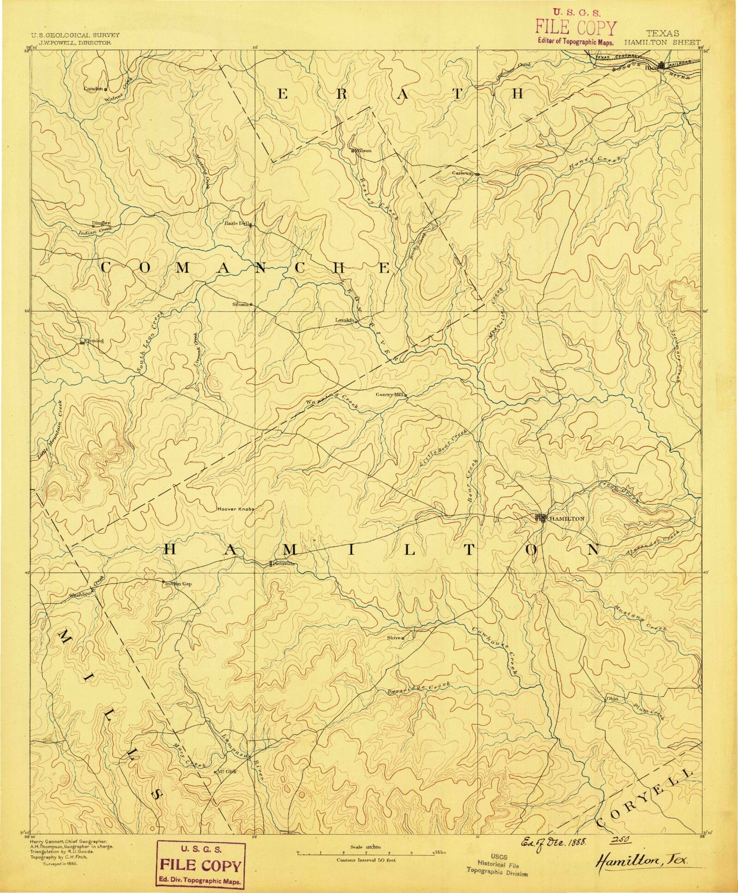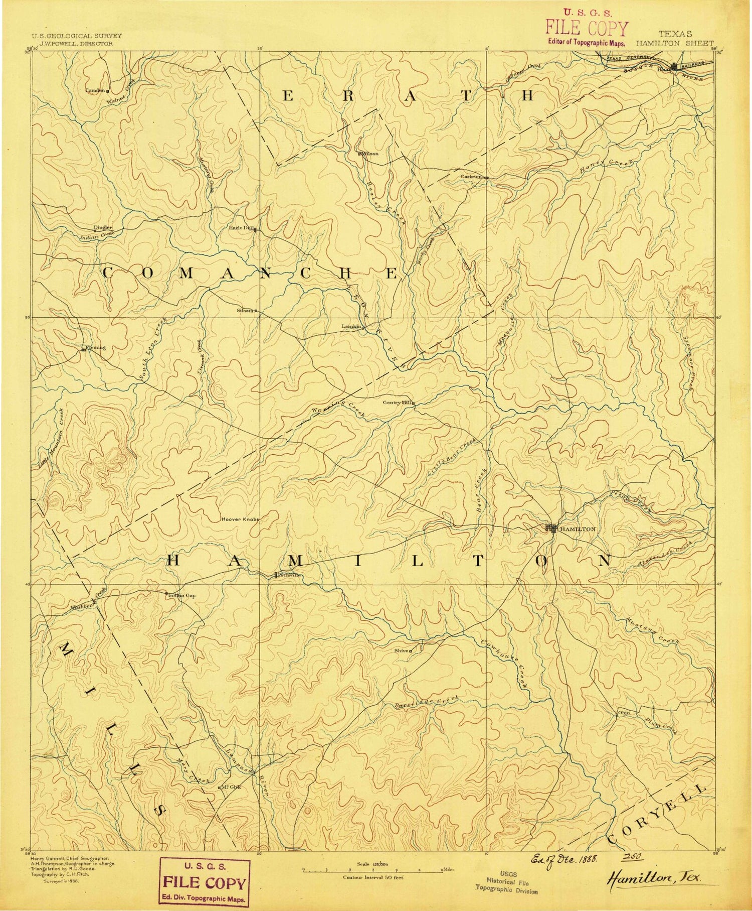
MyTopo
Historic 1888 Hamilton Texas 30'x30' Topo Map
Couldn't load pickup availability
Historical USGS topographic map of Hamilton in the state of Texas. Scale: 1:125000. Print size: 17" x 24"
This map was published in 1888 and is in the following counties: Comanche, Coryell, Erath, Hamilton, Mills.
The map contains contour lines, roads, rivers, towns, streams, and lakes. Printed on high-quality waterproof paper with UV fade-resistant inks.
Contains the following named places: Aleman, Alex Branch, Baggett Creek, Bear Creek, Becker Mountain, Bee Branch, Blue Ridge, Carlton, Chappell Creek, City Lake, Cowhouse Mountain, Craig Hill, Dooley Mountain, Dry Fork, Dry Joplin Creek, Egg Creek, Eidson Lake, Energy, Fourmile Creek, Gilmore Creek, Grubbs Branch, Gum Branch, Gustine, Hamilton, Hoover Knobs, Indian Creek, Indian Creek, Indian Gap, Lightning C Ranch, Little Bear Creek, Little Egg Creek, Little Gilmore Creek, Little Mountain Creek, Live Oak Creek, Logan Branch, Long Branch, Long Hollow, Mackey Branch, Mesquite Creek, Mesquite Creek, Mustang Creek, Owl Hollow, Pecan Creek, Pecan Creek, Pottsville, Pottsville Gas Field, Proctor, Proctor Lake, Resley Creek, Rocky Creek, Rush Creek, Salt Branch, Salt Branch, Sand Mountain, Sawyer Branch, Schoen Mountain, Slick Hill, South Mesquite Creek, Spring Branch Hiller Slough, Spring Creek, Turkey Branch, Twomile Creek, Walnut Creek, Walnut Creek, Warren Creek, Wolf Prong Creek, Barner Hollow, Blackburn Hollow, Buzzard Hollow, Caradan, Cave Hollow, Chaney Point, Deadman Mountain, Dry Branch, Earl Point, Gholson Creek, Harrington Cove, Hawley Point, Henderson Creek, Hill Ranch, Hoffman Branch, Huckabee Hill, Liberty School, Little Round Mountain, Lookout Mountain, McGirk School, Merrell Creek, Newton Point, Partridge Creek, Pete Hollow, Round Mountain, Saint Pauls School, Sand Branch, Shive, Snake Hollow, South Lampasas River, Vista Mountain, West Point, Whitlock Hollow, Baptist Branch, Dargan Creek, Gholson Creek, Hico, Holmsley Creek, Jacks Hollow Branch, Little Cowhouse Creek, Long Branch, Mills Creek, Mountain Creek, Salt Creek, School Land Creek, South Leon River, Sowells Creek, Washboard Creek, Wet Joplin Creek, Edna Hill, Fleming, Gentrys Mill, Hasse, Hazeldell, Lamkin, Midway, Olin, Siloam, Springtown, Spurlin, Sunshine, Wilson, Ballard Crossing, Ohio, Parsley Crossing, Pecan Wells, Schoolerville, Slab Crossing, Springdale, Vista, Hamilton County, Blue Bonnet Country Club, Kooken Field Stadium, Perry Country Club Golf Course, City of Hamilton Dam, Soil Conservation Service Site 28 Dam, Soil Conservation Service Site 28 Reservoir, Soil Conservation Service Site 18 Dam, Soil Conservation Service Site 18 Reservoir, Soil Conservation Service Site 19 Dam, Soil Conservation Service Site 19 Reservoir, Soil Conservation Service Site 25 Dam, Soil Conservation Service Site 25 Reservoir, Soil Conservation Service Site 27 Dam, Soil Conservation Service Site 27 Reservoir, McCasland Lake Number 3 Dam, McCasland Lake Number 3, Parker Lake Dam, Parker Lake, Soil Conservation Service Site 23 Dam, Soil Conservation Service Site 23 Reservoir, Soil Conservation Service Site 22 Dam, Soil Conservation Service Site 22 Reservoir, Soil Conservation Service Site 21 Dam, Soil Conservation Service Site 21 Reservoir, Soil Conservation Service Site 20 Dam, Soil Conservation Service Site 20 Reservoir, Soil Conservation Service Site 24 Dam, Soil Conservation Service Site 24 Reservoir, Soil Conservation Service Site 4 Dam, Soil Conservation Service Site 4 Reservoir, L M Whitely Dam, L M Whitely Lake, Soil Conservation Service Site 2 Dam, Soil Conservation Service Site 2 Reservoir, Soil Conservation Service Site 3 Dam, Soil Conservation Service Site 3 Reservoir, McCasland Lake Number 2 Dam, McCasland Lake Number 2, McCasland Lake Number 1 Dam, McCasland Lake Number 1, Soil Conservation Service Site 3 Dam, Soil Conservation Service Site 3 Reservoir, Soil Conservation Service Site 5 Dam, Soil Conservation Service Site 5 Reservoir, Soil Conservation Service Site 4 Dam, Soil Conservation Service Site 4 Reservoir, Harris Dam, Edison Lake, Joseph Lake Dam, Joseph Lake, Caldwell Lake Number 1 Dam, Caldwell Lake Number 1, Caldwell Lake Number 2 Dam, Caldwell Lake Number 2, Caldwell Lake Number 3 Dam, Caldwell Lake Number 3, McCasland Lake Dam, McCasland Lake, Hunt Lake Dam, Hunt Lake, Stillwell Lake Dam, Stillwell Lake, Graves Lake Dam, Graves Lake, Gustine Division, Hamilton Division, Hico Division, Gustine Stadium, Hamilton City Park, Sowell Creek Park, McGirk, Energy, City of Hamilton, City of Hico, Town of Gustine