MyTopo
Historic 1896 Harney Peak South Dakota 30'x30' Topo Map
Couldn't load pickup availability
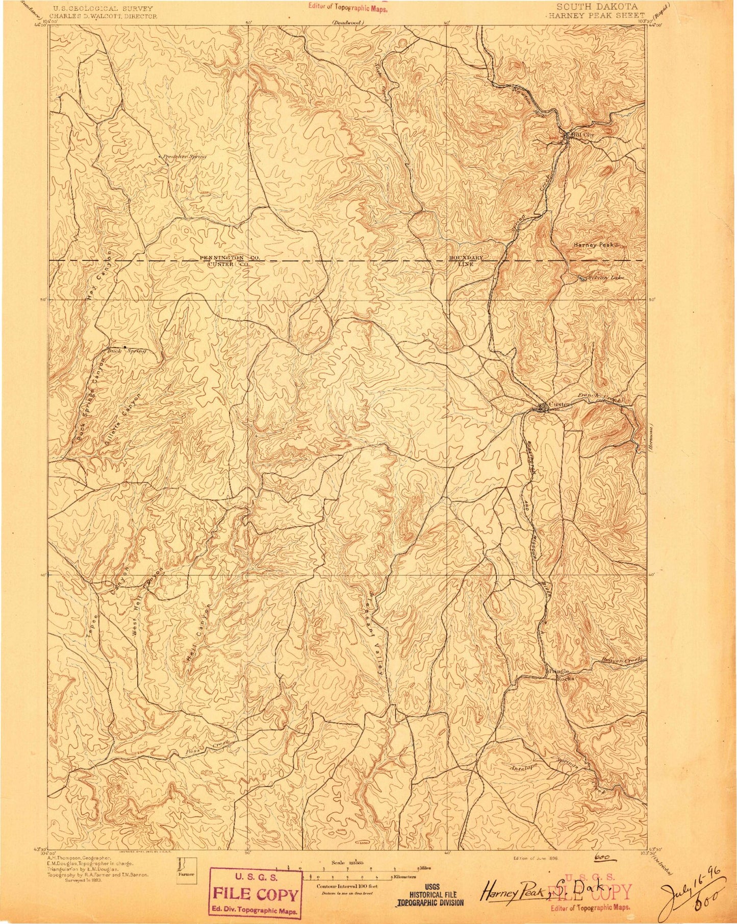
Historical USGS topographic map of Harney Peak in the state of South Dakota. Scale: 1:125000. Print size: 16" x 24"
This map was published in 1896 and is in the following counties: Custer, Pennington.
The map contains contour lines, roads, rivers, towns, streams, and lakes. Printed on high-quality waterproof paper with UV fade-resistant inks.
Contains the following named places: Putnam Dam, Red Point Canyon, Breasne Dam, Accidental Mine, Allen Gulch, Antelope Canyon, Antelope Draw, Antelope Ridge, Argyle, Atlantic Hill, Battle Creek, Bear Gulch, Bear Mountain, Bear Spring Creek, Beaver Valley, Beecher Number Two Mine, Berne, Bishop Mountain, Black Miner Gulch, Bobcat Gulch, Booker Ranch, Bowman Draw, Bowman Ranch, Bowman Ridge, Buckhorn Mountain, Bugtown Gulch, Burnt Fork, Calamity Peak, Capstick Ranch, Carroll Creek, Castle Rock, Cathedral Spires, China Gulch, Cicero Peak, Clara Belle Mine, Coon Creek, Cooper Ranch, Cooper Ridge, Copper Mountain, Corey Ranch, Coulsen Hughes Draw, Cowboy Gulch, Crow Creek, Crown Mine, Custer Mountain, Danby Park, Dead Horse Flats, Dean Ranch, Ditch Creek, Dolcode Mine, Doll Ranch, Duck Lake, Dugout Creek, Dumbuk Ridge, Dunbar Ranch, East China Gulch, East Fork Ruby Creek, East Pass Creek, Echo Valley, Eldorado Mine, Elk Knob, Elkhorn Mountain, Elliot Ranch, Elliot Ridge, Empire Mine, Five Points, Flag Mountain, Flutter Ranch, Ford Mountain, Fossil Ridge, Fourmile, Fourmile Creek, Gahl Ranch, Gap Lode Mine, Gillette Prairie, Gillis Ranch, Gladys Nells Mine, Glen Erin Creek, Gold Mountain Mine, Gooseberry Draw, Graveyard Gulch, Griffis Canyon, Grizzly Bear Mine, Hammock Ranch, Black Elk Peak, Harris Ranch, Hat Mountain, Haven Canyon, Hay Creek, Hay Draw, Hay Draw, Hay Draw, Heely Creek, Helen Beryl Mine, Hell Canyon, Herman Matt Ranch, Hidden Treasure Mine, Highland Lode, Hoar Ranch, Hood Tunnel, Hop Draw, Hopkins Flats, Humbolt Mountain, J R Mine, Jewel Cave National Monument, Johnson Canyon, Junction Ranger Station, King Tut Mine, Laughing Water Creek, Layton Canyon, Lemming Draw, Lena Gulch, Lightning Creek, Linwood Mine, Lithograph Canyon, Little Devils Tower, Little Thompson Draw, Long Draw, Long Draw, Long Draw, Loues Creek, Lowden Mountain, Lucky Strike Mine, Lucky Strike Mine, Lyman Draw, Major Lake, Marshall Gulch, Martin Draw, McAdam Ranch, McClure Dam, McCurran Ranch, Medicine Mountain, Middle Fork French Creek, Mile-high Hill, Minnie May Mine, Morrison Ranch, Mud Lake, Myrtle Ann Mine, Needle Eye, Negro Creek, Nelson Creek, New York Mine, Newton Fork, Newton Park, Nicolls Ranch, Ninemile Draw, North Fork French Creek, Odakota Mountain, Old Bill Mine, Old Mike Mine, Oreville, Palmer Creek, Patterson Creek, Penalua Gulch, Penobscott Mine, Pilger Mountain, Lake of the Pines, Pitts Ranch, Pleasant Valley, Pleasant Valley Creek, Pole Creek, Rabbit Gulch, Rainbow Number Four Mine, Red Butte, Red Dog Gulch, Red Spar Mine, Redbird Draw, Reder Ranger Station, Reede Mine, Reno, Reno Gulch, Reno Gulch Park, Retzloff Ranch, Rocky Ridge Mine, Roetzel Deer Camp, Rogers Lake, Rose Quartz Mine, Round Mountain, Ruby Creek, Ruby Gulch, S and G Canyon, Sagers Ranch, Saint Elmo Peak, Sanator, Sawmill Draw, Schenk Canyon, Sears Ranch, Shephard Ranch, Shirttail Canyon, Short Fork, Sidney Creek, Signal Hill, Sixmile Draw, Smith Mountain, Smith Ranch, Smith Ranch, Soper Ranch, Sourdough Draw, South Fork French Creek, South Fork Whaley Gulch, South Slate Creek, Stan-Penn Lodge Mine, Stapp Quarry, Storm Hill, Sturm Ranch, Summit Mine, Summit Peak, Sunday Gulch, Sunnyside Mine, Surveyors Hill, Sutherland Ranch, Sylvan Lake, Tanner Ranch, Tanner Ranch, Taylor Ranch, Tenderfoot Creek, Tenderfoot Gulch, Tepee Canyon, The Needles, Theater Ridge, Thompson Draw, Thunderhead Mountain, Tin Mountain Mine, Tiptop Mine, Toe Gulch, Tony Matt Ranch, Townsite Mine, Tree Draw, Triangle A Mine, Twin Lakes, Twin Sisters, Twin Sisters Range, Union Hill, Vanderlehr Creek, Ventling Ranch, Ventling Ranch