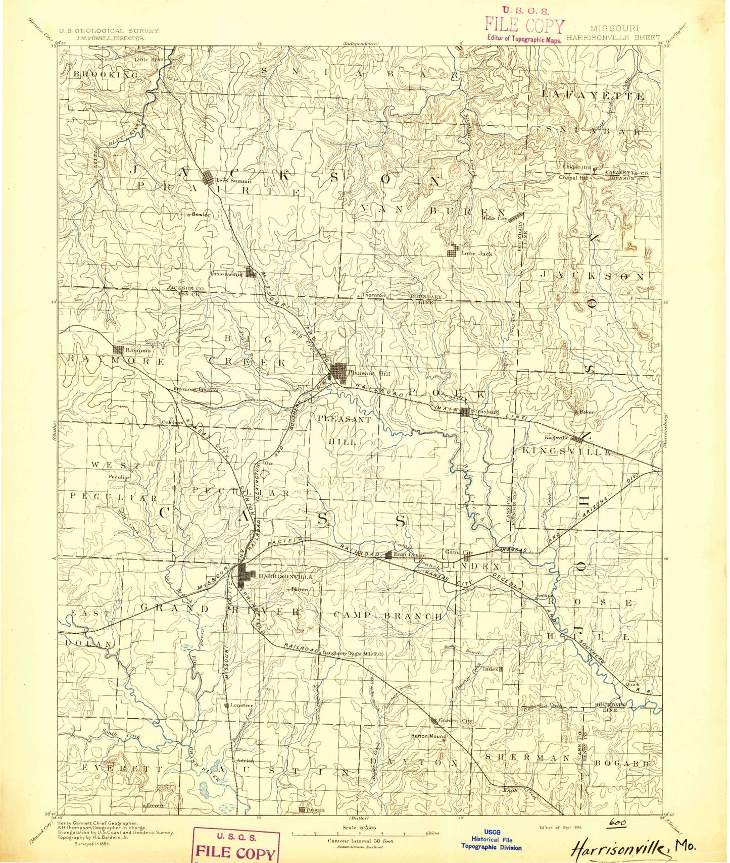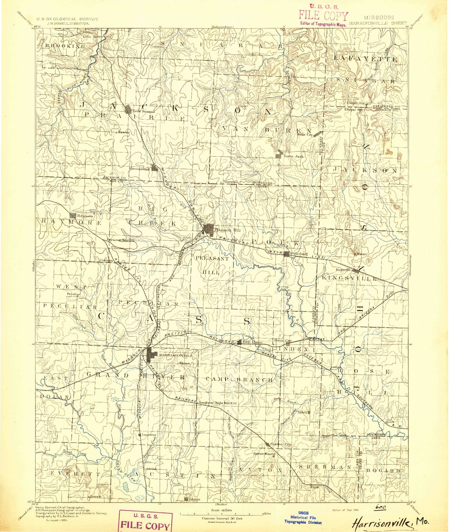
MyTopo
Historic 1894 Harrisonville Missouri 30'x30' Topo Map
Couldn't load pickup availability
Historical USGS topographic map of Harrisonville in the state of Missouri. Scale: 1:125000. Print size: 17" x 24"
This map was published in 1894 and is in the following counties: Cass, Henry, Jackson, Johnson, Lafayette.
The map contains contour lines, roads, rivers, towns, streams, and lakes. Printed on high-quality waterproof paper with UV fade-resistant inks.
Contains the following named places: Poney Creek, Adams Branch, Alexander Creek, Allendale Lakes, Austin, Baldwin Lake, Bieger Mound, Big Rock Bay, Black Creek, Bodenhammer Hill, Bogard Creek, Brookhart Hill, Buffalo Cove, Camp Branch, Catclaw Lake, Cedar Creek, Christiansen Mound, City Lake, Cockrell, Crawford Creek, Crooked Branch, Daugherty, Dolan Mound, Dorsett Hill, Duncan Branch, East Branch, East Branch Crawford Creek, East Branch South Grand River, East Fork East Branch South Grand River, East Lynne, Elm, Elm Branch, Emrick Hill, Everett, Flaceys Lake, Fleming Park, Franklin Lakes, Garden City, Gopher Lake, Greenwood, Gunn City, Gunn City, Harrisonville, Harrisonville City Lake, Herrell Hill, Hilltop Mound, Hornsby Branch, Jackrabbit Lake, James A Reed Memorial Wildlife Area, Joslin Branch, Kellogg Lake, Kestersen Lake, Knobtown, Kohler Hill, Lake Lotawana, Lakewood Lakes, Little Cedar Creek, Little Walnut Creek, Lone Tree, Lost Creek, Lake Lotawana, Louse Run, Lake Luna, Masters Hill, Middle Big Creek, Miller Hill, Mound Valley, Mouse Creek, Muddy Creek, Narojo Lake, North Prairie Lee Park, Old Peculiar, Osburn Mound, Owens Creek, Panther Creek, Peculiar, Pleasant Hill, Polecat Creek, Quick City, Rattlesnake Hill, Raymore, Rock Island Lake, Rock Island Lake, Rocky Branch, Rotary Camp, Scaly Bark Creek, Schindorff Hill, Shady Lake, Sni Mills, Snowball Hill, South Fork South Grand River, South Prairie Lee Park, Staley Mound, Steen Mound, Summit Park, Sunset Bay, Tarsney, Tarsney Lakes, Tennessee Creek, Town Creek, Unity Tower, Unity Village, Van Lake, Walnut Creek, West Branch Crawford Creek, West Branch Lost Creek, West Fork Sni-A-Bar Creek, Wildwood Lakes, Willow Branch, Wilson Creek, Wingate, Lake Winnebago, Wolf Creek, Coon Creek, Devil Ridge, East Lost Creek, Kingsville, Latour, Clear Creek, Strasburg, Lumpkins Fork, Unity Lake Number One, White Oak Creek, Bowler Hill, Union Point, Sni Mill, Lees Summit, Parkway Shopping Center, Loma Vista East, Robandee Shopping Center, Buckeye Square, Summit Shopping Center, Coach Lamp Shopping Center, Little Blue River Lakes, Chapel Hill, Little Blue, Fulkerson, Skaggs, Avon, Coleman, Fenwick, Gowdy, Hadsell, Harrelson, Huber, Longview, Ore, Prettyman, Rose Hill, South Lee, Vale, Jackson County Park Headquarters, Westchester Village Shopping Center, Valle Vista Shopping Center, Summit Springs Shopping Center, Barton, Kansas City International Drag Strip, Turner Golf Course, Hicks City, Kaysinger Basin Planning Region, Cottontail Lake, Lake Jacomo, Loch Leonard, Lone Jack, Lake Nell, Pleasant Hill Lake, Plover Lake, Prairie Lee Lake, Tarsney Lake, Wood Lake, Medford, Cass County, Longview Farm, Holden City Lake, Prairie Lee Lake Dam, Lake Jacomo Dam, Oakland Farms Lake Dam, Oakland Farms Lake, Baldwin Dam, Pleasant Hill Lake Dam, Longview Dam - North, Old Longview Lake, Longview South Dam, New Longview Lake, Kesterson Dam, South Fork Blackwater River Watershed Dam A-20, Johnson Number A-1 Dam, Echo Lake, South Fork Blackwater River Watershed Dam A-21, Catclaw Lake Dam, Cottontail Lake Dam, Bluestem Lake Dam, Reed Area Number 10 Lake, Jackrabbit Lake Dam, Plover Lake Dam, Lake Nell Dam, Bodarc Lake Dam, Reed Area Number 9 Lake, Gopher Lake Dam, Reed Area Number 3 Dam, Coot Lake, Unity Lake Number 1 Dam, Lake Lotawana Dam, Wildwood Dam, Wildwood Lake, Silverlake Enterprizes Lake Dam, Silver Lake, Harper Lake Dam, Harper Lake, South Fork Blackwater River Watershed Dam E-24, Johnson E-24 Lake, Johnson County A-26 Dam, Spiwak Lake, Lake Luna Dam, Harrisonville City Lake Dam, North Lake Dam, North Lake, Fairview Farms Lake Dam, Nelly Don Lake, Lone Summit Lake Dam, Number 38 Lake, Unity Lake Number 2 Dam, Unity Lake Number Two, Wood Lake Dam, Tarsney Lake Dam, Mononame 83 Dam, Mononame 83 Lake, Aylward Lake Dam, Aylward Lake, Mononame 87 Dam, Mononame 88 Dam, Christiansen Lake Dam, Christiansen Lake, Deerhorn Lake Dam, Number 93 Lake, Lake Paradise Dam