MyTopo
Historic 1894 Hayrick Texas 30'x30' Topo Map
Couldn't load pickup availability
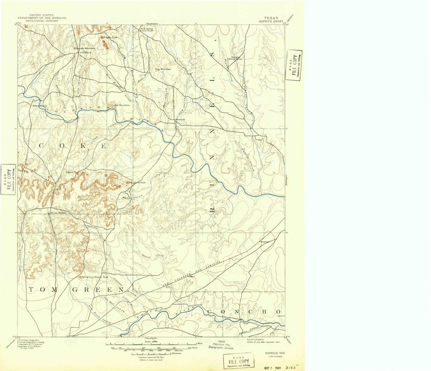
Historical USGS topographic map of Hayrick in the state of Texas. Scale: 1:125000. Print size: 25" x 24"
This map was published in 1894 and is in the following counties: Coke, Concho, Runnels, Tom Green.
The map contains contour lines, roads, rivers, towns, streams, and lakes. Printed on high-quality waterproof paper with UV fade-resistant inks.
Contains the following named places: Allen Number One Windmill, Antelope Creek, Antelope Creek, Ballinger City Lake, Bowen Draw, Bronte Oil Field, Buffalo Creek, Bull Hollow, Butterfield Canyon, Butterfield Peak, Cedar Creek, Cedar Mountain, Cement Creek, Cement Mountain, Cobb Creek, Cow Creek, Deadman Canyon, Dry Creek, Dry Hollow, East Kickapoo Creek, Hayrick Mountain, Herring Ranch, Hog Creek, Hog Mountain, Indian Creek, Indian Creek, Jack Miles Creek, Jones Peak, Juniper Creek, Juniper Peak, Kickapoo Creek, Kickapoo Mountain, Kristoff School, Little Round Mountain, Liveoak Ridge, Machae Creek, Mount Margaret, Marie, Maverick, McCuthen Oil Field, Mesquite Creek, Messbox Creek, Middle Kickapoo Creek, Motley Oil Field, Mountain Creek, Mountain Creek Reservoir, Munn Oil Field, Mustang Branch, Nipple Peak, Nipple Peak, Norton, Oak Creek, Old City Lake, Orient, Panther Gap, Quarry Creek, Rawlings Oil Field, Red Bank Creek, Robert Lee, Rocky Creek, Rowena, Rowena Oil Field, Sand Hill, Skinner School, Spring Canyon, Storey Creek, Tennyson, Turkey Creek, Gobbler Hill, Valley Creek, Valley View, Wagon Tire Creek, Wendland Oil Field, Wilmeth, Wooland Siding, Battle Creek, Devils Courthouse Peak, Dry Hollow, Harriet School, Kiesling School, Lowake, Miles, Puddle Creek, Sales Branch, Sikes School, Tenmile Creek, Double Barrel Creek, Liveoak Creek, Bronte, Crows Nest Creek, Lipan Creek, Little Crows Nest Creek, Mule Creek, Red Creek, Valentine Branch, West Kickapoo Creek, Willow Creek, Shawville, Harriet, Mullins Crossing, Seventeen Mile Crossing, Sixteen Mile Crossing, Lake View Stadium, Chandler Dam, Jeschke Dam, Jeschke Lake, Erwin-Jordan Dam, Erwin-Jordan Reservoir, Krall Dam, Krall Reservoir, Kuhn Lake Dam, Kuhn Lake, Currie Lake Dam, Currie Lake, Lake Ballinger Dam, Moore Lake Dam, Moore Lake, Lloyd Lake Dam, Lloyd Lake, Allen Lake Dam, Allen Lake, Soil Conservation Service Site 18 Dam, Soil Conservation Service Site 18 Reservoir, Soil Conservation Service Site 19 Dam, Soil Conservation Service Site 19 Reservoir, Soil Conservation Service Site 20 Dam, Soil Conservation Service Site 20 Reservoir, W D Coleman Lake Dam, W D Coleman Lake, Soil Conservation Service Site 1 Dam, Soil Conservation Service Site 1 Reservoir, Mountain Creek Dam, Old City Lake Dam, Soil Conservation Service Site 2 Dam, Soil Conservation Service Site 2 Reservoir, Soil Conservation Service Site 3 Dam, Soil Conservation Service Site 3 Reservoir, Soil Conservation Service Site 5 Dam, Soil Conservation Service Site 5 Reservoir, Soil Conservation Service Site 6 Dam, Soil Conservation Service Site 6 Reservoir, Edward Rawling Lower Tank Dam, Edward Rawling Lower Tank, Edward Rawling Upper Tank Dam, Edward Rawling Upper Tank, Baca Lake Dam, Baca Lake, Soil Conservation Service Site Dam Number 1, Soil Conservation Service Site Number 1 Reservoir, Soil Conservation Service Site Number 2 Dam, Soil Conservation Service Site Number 2 Reservoir, Old City Lake Dam, Old City Lake, Stoker Lake Dam, Stoker Lake, Rattle Snake Hill, Deep Hollow, Chandler Lake, Kiser Mountain, Brooks Hill, Deadman Hill, Pecan Mott, Buttermilk Hill, Bronte Division, Miles Division, San Angelo Coliseum, Cactus Lane Park, San Angelo Fairgrounds, Valley View, Marie, Kiesling, City of Robert Lee, City of Miles, Town of Bronte