MyTopo
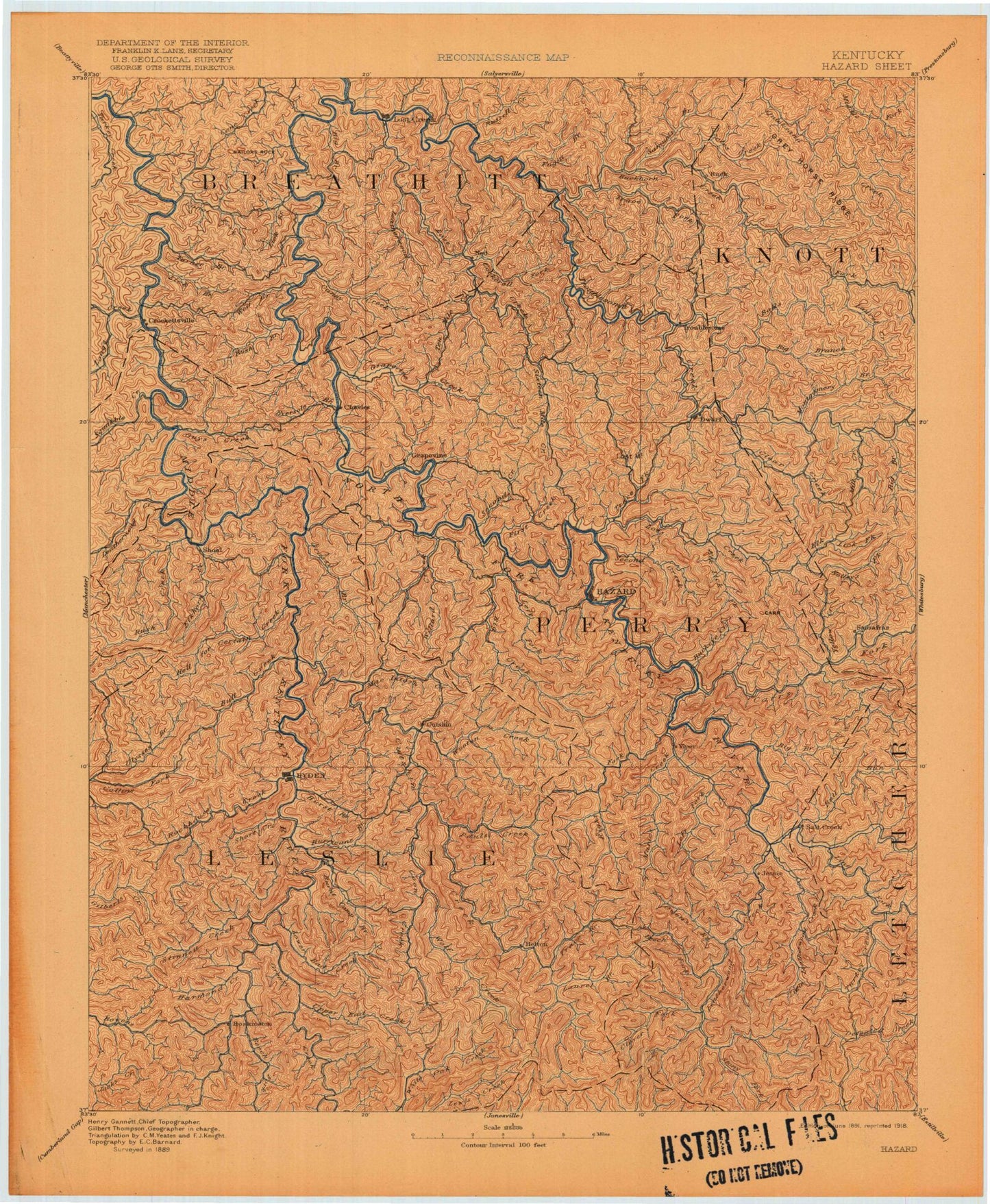
Historic 1891 Hazard Kentucky 30'x30' Topo Map
Couldn't load pickup availability
Historical USGS topographic map of Hazard in the state of Kentucky. Scale: 1:125000. Print size: 17" x 24"
This map was published in 1891 and is in the following counties: Breathitt, Harlan, Knott, Leslie, Letcher, Perry.
The map contains contour lines, roads, rivers, towns, streams, and lakes. Printed on high-quality waterproof paper with UV fade-resistant inks.
Contains the following named places: Cockrell Fork, John Noble Fork, Acup Branch, Airport Gardens, America Branch, Baker Branch, Baker Branch, Ball Branch, Balls Fork, Barge Creek, Barn Branch, Bear Branch, Bear Branch, Bear Branch, Bearwallow Branch, Bee Branch, Bee Branch, Bee Branch, Bee Creek, Beech Branch, Beech Creek, Big Branch, Big Branch, Big Branch, Big Branch, Big Branch, Big Cutoff Branch, Big Fork, Big Hollow, Big Laurel Branch, Birch Branch, Blueford Hollow, Boardinghouse Branch, Bonnyman, Booker Fork, Boughcamp Branch, Bowman Branch, Bradley Branch, Broadtree Branch, Broadtree Hollow, Brushy Branch, Brushy Fork, Buck Branch, Buck Fork, Buckeye Hollow, Buckhorn Branch, Buckhorn Creek, Bucklick Branch, Bucklick Branch, Bucklick Hollow, Bucklick Hollow, Buffalo Branch, Bulan, Bull Creek, Buzzard Den Branch, Calf Hollow, Camp Branch, Camp Robinson University of Kentucky Engineering Camp, Campbell Branch, Campbell Branch, Campbell Branch, Cane Branch, Caney Creek, Caney Creek, Cat Hollow, Chestnut Log Branch, Cinder Knob, Clear Creek, Clemons Fork, Coalstone Branch, Coates Branch, Cob Hollow, Cockerell Trace Branch, Coles Fork, Coles Fork, Combs, Combs Branch, Coon Hollow, Core Branch, Cornettsville, Cotton Hollow, Cow Branch, Crabapple Branch, Cutoff Branch, Dans Fork, Darb Fork, Darfork, Dark Branch, Deadland Branch, Deadmans Hollow, Deephole Branch, Devilhouse Branch, Dicks Fork, Dickson Branch, Dixon Branch, Dixon Knob, Dog Hollow, Doty Branch, Dry Bread Branch, Durg Branch, Dwarf, Dykes Branch, Eli Fork, Elic, Elisha Fork, Elisha Fork, Elk Fork, Elkbutt Knob, Elklick Fork, Elm Shoal Branch, Emory Branch, Engle Fork, Fallenrock Branch, Fallenrock Branch, Falling Rock Branch, Field Branch, Field Branch, Fifteenmile Creek, Firescald Branch, Fishtrap Branch, Fishtrap Branch, Fort Branch, Francis Branch, Francis Branch, Franks Fork, Fugate Fork, Fugate Fork, Ganderbill Branch, Garden Branch, Garden Branch, Gearhart Fork, George Branch, Gin Hollow, Grassy Gap Fork, Grassy Hollow, Grey Horse Hill, Grigsby Branch, Grithy Branch, Guy Cove, Haddix, Happy, Hard Branch, Hardburly, Harris Branch, Harveyton, Hays Branch, Hen Branch, Hickory Gap, Hickory Log Branch, Hickory With Branch, Hiram Fork, Holiness Hollow, Hollins Fork, Hominy Mill Branch, Honey Gap Hollow, Hurricane Branch, Hurricane Branch, Hurt Fork, Improvement Branch, Jack Branch, Jacks Branch, Jake Branch, Jake Fork, Jakes Branch, Jenny Fork, John Carpenter Fork, John Littles Branch, John Noble Fork, John Riley Branch, John S Combs Branch, Johnson Lick Branch, Kelly Branch, Kelly Fork, Kelly Fork, Kitchen Branch, Kitchen Fork, Kodak, Lane Branch, Laurel Branch, Laurel Fork, Laurel Fork, Laurel Fork, Laurel Fork, Laurel Fork Quicksand Creek, Leatherwood Creek, Left Fork Caney Creek, Left Fork Elk Fork, Left Fork Trace Fork, Levis Branch, Lewis Fork, Lick Branch, Lick Branch, Lick Branch, Lick Branch, Lick Branch, Lick Fork, Little Leatherwood Creek, Little Millseat Branch, Long Branch, Long Branch, Long Fork, Long Point Branch, Loomhouse Branch, Lost Creek, Lost Mountain, Lotts Creek, Low Gap Branch, Low Gap Branch, Lower Bearpen Branch, Lower Beaverdam Branch, Lower Field Branch, Lower Laurel Branch, Lower Lick Fork, Lower Whit Branch, Lowerfield Hollow, Lynn Log Branch, Mac and Nellie Branch, MacIntosh Fork, Maple Hollow, Mare Branch, Mart Branch, Mart Branch, McGilton Branch, McIntire Hollow, Meadow Branch, Meadow Branch, Meadowbrook Hollow, Messer Fork, Middle Fork Quicksand Creek, Mill Branch, Mill Branch, Mill Branch, Mill Branch, Mill Creek, Miller Branch, Miller Branch