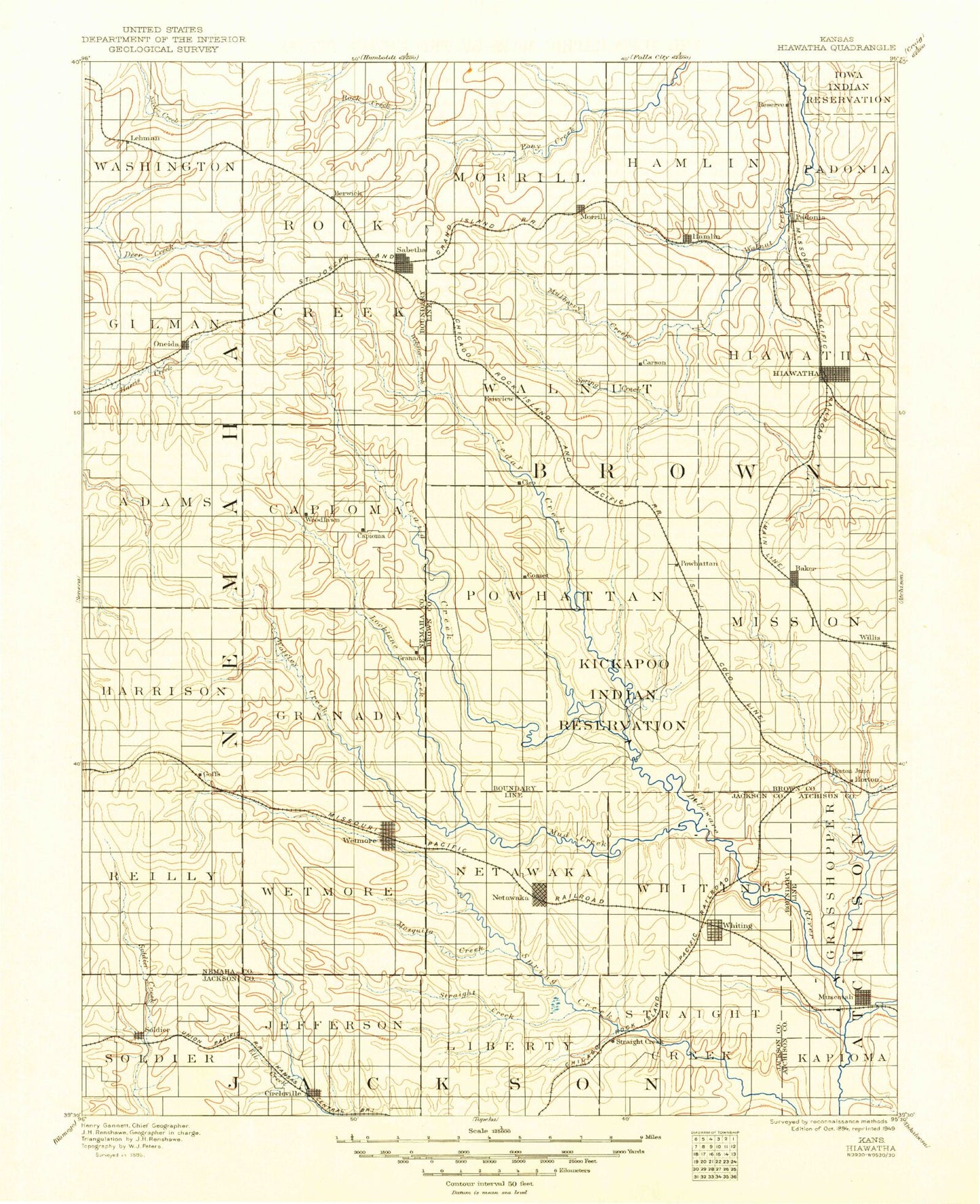
MyTopo
Historic 1894 Hiawatha Kansas 30'x30' Topo Map
Couldn't load pickup availability
Historical USGS topographic map of Hiawathain the states of Kansas, Nebraska. Scale: 1:125000. Print size: 17" x 24"
This map was published in 1894 and is in the following counties: Atchison, Brown, Jackson, Nemaha, Richardson.
The map contains contour lines, roads, rivers, towns, streams, and lakes. Printed on high-quality waterproof paper with UV fade-resistant inks.
Contains the following named places: Township of Soldier, Township of Washington, Township of Gilman, Sabetha City Lake, Wolf Pen Creek, Bern, Township of Berwick, Township of Rock Creek, Township of Morrill, Township of Walnut, Webster Creek, Spring Creek, Sabetha, Mulberry Creek, Berwick, Hamlin, Morrill, Terrapin Creek, Pedee Creek, Township of Hamlin, Euchre Creek, Spring Branch, Padonia, Reserve, Township of Padonia, Township of Adams, Township of Capioma, Oneida, Wolfley Creek, Muddy Creek, Township of Powhattan, Craig Creek, Plum Creek, Capioma, Woodlawn, Cedar Creek, Squaw Creek, Powhattan, Fairview, Township of Mission, Little Delaware River, Baker, Lake Hiawatha, Hiawatha, Township of Harrison, Township of Reilly, Township of Wetmore, Spring Creek, Goff, Barnes Creek, Township of Granada, Wetmore, Granada, Township of Netawaka, Township of Whiting, Mission Creek, Otter Creek, Clear Creek, Horton, Mission Lake, Mission Lake Camp, Willis, Mercier, Soldier, Bancroft, Mosquito Creek, Township of Jefferson, Circleville, Township of Liberty, Township of Straight Creek, Netawaka, Negro Creek, Muscotah, Whiting, Lake of the Oaks, Brush Creek, South Creek, Little Grasshopper Creek, Kickapoo Reservation, Hiawatha City Dam, Mission Lake Dam, Whiting City Dam, Albany Hill, Fairway Shops, Fidelity, Ontario, Sun Springs, Brown County, Hiawatha Country Club, Horton Lakeview Country Club, City of Hiawatha, City of Horton, City of Sabetha, City of Circleville, City of Bern, City of Hamlin, City of Fairview, City of Goff, City of Muscotah, City of Netawaka, City of Morrill, City of Soldier, City of Oneida, City of Powhattan, City of Reserve, City of Wetmore, City of Whiting, City of Willis, Whiting Wastewater Treatment Facility, Willis Wastewater Plant, Sabetha Wastewater Treatment Facility, Wetmore Wastewater Treatment Facility, Hiawatha City of North, Goff Wastewater Plant, Soldier Wastewater Treatment Plant, Bern Wastewater Plant, Netawaka Wastewater Treatment Plant, Powhattan Wastewater Plant, Muscotah Wastewater Treatment Facility, Horton Municipal Power Plant, Sabetha Municipal Power Plant, Kansas Department of Transportation Brown County Rest Area, Hiawatha Aquatic Park, Davis Memorial, Circleville Wastewater Plant, Hiawatha Wastewater Plant Number 3, Horton Wastewater Plant, Kickapoo Tribe Wastewater Treatment Facility, Morrill Wastewater Treatment Facility, Fairview Wastewater Treatment Facility, Oneida Wastewater Treatment Plant, Cowpoke Mobile Home Park, Mulberry Creek Resort Recreational Vehicle Park, Sycamore Springs Recreational Vehicle Resort, Sabetha Golf Club, Agricultural Partners Co - Operative Grain Elevator Number 1, Agricultural Partners Co - Operative Grain Elevator Number 3, Agricultural Partners Co - Operative Grain Elevator Number 4, Agricultural Partners Co - Operative Grain Elevator Number 5, Agricultural Partners Co - Operative Grain Elevator Number 6, Agricultural Partners Co - Operative Grain Elevator Number 9, Lortscher Agricultural Service Grain Elevator Number 1, Jackson Farmers Grain Elevator Number 6, Farmers Co - Operative Elevator Grain Elevator Number 1, Morrill Elevator Grain Elevator Number 1, Bodenhausen Farms, Swart Creek, Pedee Creek