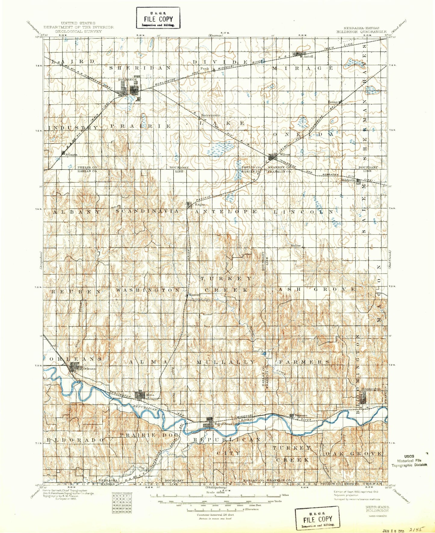
MyTopo
Historic 1896 Holdrege Nebraska 30'x30' Topo Map
Couldn't load pickup availability
Historical USGS topographic map of Holdrege in the state of Nebraska. Scale: 1:125000. Print size: 17" x 24"
This map was published in 1896 and is in the following counties: Franklin, Harlan, Kearney, Phelps, Phillips, Smith.
The map contains contour lines, roads, rivers, towns, streams, and lakes. Printed on high-quality waterproof paper with UV fade-resistant inks.
Contains the following named places: Sappa Creek, Dry Creek, Harlan County Lake, Walnut Creek, Bone Creek, Crow Creek, Rebecca Creek, Patterson Creek, Lost Creek, Prairie Dog Creek, Alma, Alma Vista Picnic Area, Ash Creek, Atlanta, Atlanta Marsh, Atlanta Marsh National Wildlife Management Area, Big Cottonwood Creek, Bloomington, Boat Ramp, Bone Cove, Cedar Point, Cook Creek, Coyote Canyon, Crystal Creek, Eureka Creek, Flag Creek, Funk, Gremlin Cove, Harlan County Dam, Hildreth, Holdrege, Huntley, Indian Hill, Little Cottonwood Creek, Lochile Creek, Methodist Cove, Methodist Creek, Mill Creek, Milrose Creek, Naponee, Naponee Canal, North Cove, Orleans, Patterson Harbor, Pheasant Point, Prairie Dog Bay, Ragan, Richardson Lagoon, Richardson Lagoon State Wildlife Mgt Area, Rope Canal, Rope Creek, Sacramento Creek, Sacramento-Wilcox State Wildlife Mgt Are, Sindt Point, South East Sacramento State Wildlife Mgt Are, South Sacramento State Wildlife Mgt Area, Spring Brook, Tipover Cove, Tipover Creek, Turkey Creek, Vinning Creek, White Cat Point, Wilcox, Republican City, Republican Station, Axtell, Clyde, Keene, Sacramento, Harlan County, Township of Albany, City of Alma, Township of Alma, Township of Antelope, Township of Ash Grove, Township of East Bloomington, Township of Divide, Township of Eldorado, Township of Hayes, City of Holdrege, Township of Laird, Township of Lake, Township of Lincoln, Township of Macon, Township of Mirage, Township of Mullally, Township of Oneida, Township of Orleans, Township of Prairie, Township of Prairie Dog, Township of Republican City, Township of Reuben, Township of Salem, Township of Scandinavia, Township of Sheridan, Township of Sherman, Township of Turkey Creek, Township of Turkey Creek, Township of Washington, James Dam, James Reservoir, Haeker Dam, Haeker Reservoir, Wolf Dam Number 1, Wolf Reservoir Number 1, Gladman-Miller Dam, Adam Dam, Adam Reservoir, Anderson Dam, Anderson Reservoir, Frerichs Dam, Frerichs Reservoir, Frerichs Dam-1 Dam, Frerichs Reservoir, Kahrs Dam, Kahrs Reservoir, Ott Dam, Ott Reservoir, Phillipson Dam, Phillipson Reservoir, Rasmussen Dam, Rasmussen Reservoir, Saathoff Dam, Saathoff Reservoir, Harlan County Dam, Harms Dam, Harms Reservoir, Martindale Dam, Martindale Reservoir, Ott Dam, Ott Reservoir, Peterson North Dam, Peterson North Reservoir, Peterson South Dam, Peterson South Reservoir, Sall Dam, Sall Reservoir, Ziegler Dam, Ziegler Reservoir, Batten Dam, Batten Reservoir, Carter-David East Dam, Carter-David East Reservoir, Carter-David West Dam, Carter-David West Reservoir, Bantom-Coe Dam, Bantom-Coe Reservoir, Einspahr Dam, Einspahr Reservoir, Flasnick Dam, Flasnick Reservoir, Massey Dam, Massey Reservoir, McDonald Dam, McDonald Reservoir, Richards Dam, Richards Reservoir, Schluntz Dam, Schluntz Reservoir, Hoffman Dam, Hoffman Reservoir, Milrose David Dam Number 2, Milrose David Reservoir Number 2, Kildeer Federal Waterfowl Production Area, Frerichs Federal Waterfowl Production Area, Prairie Dog Federal Waterfowl Production Area, Clark Federal Waterfowl Production Area, Lindau Federal Waterfowl Production Area, Gleason Federal Waterfowl Production Area, Motala, Bluestem Federal Waterfowl Production Area, Midland Co-op Elevator, Wilcox City Park, Keene Co-op Grain and Supply Company Elevator, Axtell, Midland Co-op Elevator, Walkers Ranch Historical Marker, Axtell Nebraska Historical Marker, Axtell City Park, Wac, Funk Federal Waterfowl Production Area, Jones Federal Waterfowl Production Area, South Central Co-op Elevator, Holdrege, Cargill Elevator, Westside Plaza Mobile Home Park, Holdrege City Campground, Dewaynes Trailer Court, Winquest Memorial Tennis Court, North Park, Jaycee Field, Harold P Kenfield Memorial Court, Holdrege City Park, Holdrege Country Club, Phelps County Fairgrounds, Keifer Field, Phelps County Historical Marker, Funk Nebraska Historical Marker, Harmony Park, Atlanta Prisoner of War Camp Historical Marker, Site of Old Sacramento Historical Marker, Midland Co-op Elevator, Funk, Atlanta Elevator, Atlanta, Ritterbush Federal Waterfowl Production Area, Quadhamer Federal Waterfowl Production Area, Midland Co-op Elevator, Naponee, Farmers Cooperative Grain Supply Company Elevator, Hildreth, Hunter Cove Campground, Gremlin Cove Campground, Outlet Campground, Patterson Harbor Marina Campground, Patterson Harbor Campground, North Cove Campground, Methodist Cove Campground, Harlan County Lake Recreation Area, Taylor Manor Trailer Court, Midland Co-op Elevator, North Shore Marina, Midland Co-op Elevator, Orleans RV Park, Atlanta Elevator, Orleans Elevator, Orleans, Huntley, Midland Co-op Elevator, Alma, Agri Co-op Elevator, Alma Municipal Golf Course, Alma City Park, City of Alma Trailer Park, Pioneer Crossing Historical Marker, Village of Atlanta