MyTopo
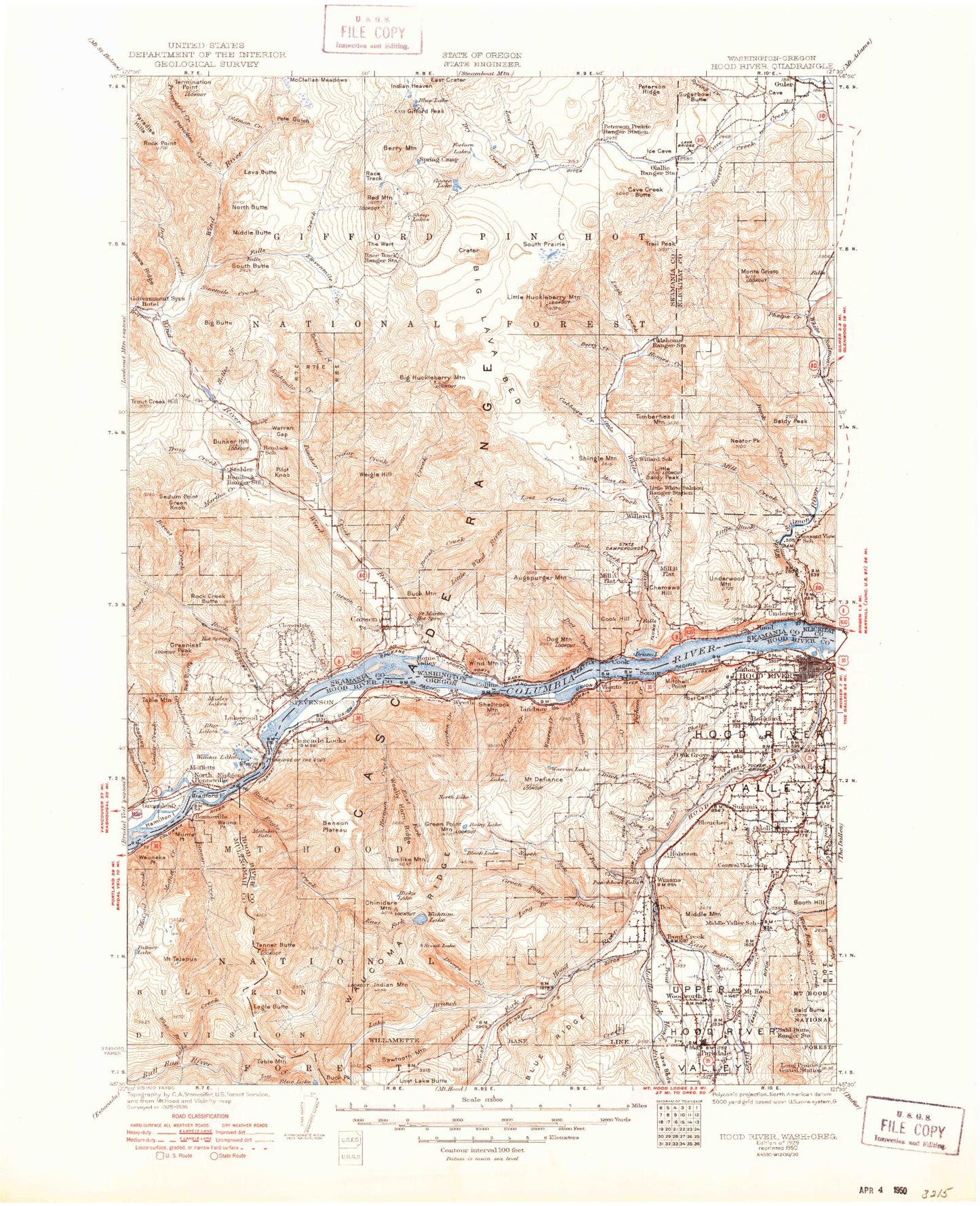
Historic 1929 Hood River Oregon 30'x30' Topo Map
Couldn't load pickup availability
Historical USGS topographic map of Hood River in the state of Oregon. Scale: 1:125000. Print size: 17" x 24"
This map was published in 1929 and is in the following counties: Hood River, Klickitat, Multnomah, Skamania.
The map contains contour lines, roads, rivers, towns, streams, and lakes. Printed on high-quality waterproof paper with UV fade-resistant inks.
Contains the following named places: Mosquito Creek, Columbia Gorge Work Center, Hunters Camp, Ridge Camp, Deadwood Camp, Winans, Booth Hill, Mitchell Point, Oak Grove, Post Canyon, Seneca Fouts Memorial State Natural Area, Summit, West Branch Falls Creek, Whiskey Creek, Willow Flat, Pine Grove, Alder Brook, Duckwall Reservoir, Ferguson Creek, Shelly Creek, Rhoades Creek, Power Canal, Moffett Falls, Trotter Point, Tanner Creek Fishway, Entrance to Bonneville Lock, Hood River, Lenz, Rockford, Van Horn, Eagle Tanner Trail, Highline Lateral, Shelley Creek, Anderson Point, Bald Butte, Baldwin Creek, Batts Meadow, Bear Lake, Benson Plateau, Birdie Creek, Black Lake, Blowdown Ridge, Boat Rock, Bonneville, Bonneville Dam, Bradford Island, Cabin Creek, Camp Creek, Camp Creek, Camp Yallani, Cascade Locks, Casey Creek, Central Lateral, Chinidere Mountain, Collins Creek, Columbia Gorge Recreation Area, Dead Point, Dee, Dee Flat, Dee Flat Ditch, Mount Defiance, Ditch Creek, Divers Creek, Dry Creek, Dublin Lake, Dukes Valley, Eagle Butte, Eagle Creek, Eagle Creek Recreation Site, Eagle Creek Trail, East Fork Eagle Creek, East Fork Herman Creek, East Fork Hood River, East Fork Main Canal, Elowah Falls, Emil Creek, Emil Creek Reservoir, Evans Creek, Falls Creek, Farmers Ditch, Gate Creek, Gorton Creek, Government Cove, Graham Creek, Grays Creek, Green Point Creek, Green Point Lower Reservoir, Green Point Mountain, Green Point Upper Reservoir, Griswell Creek, Harphan Creek, Hazel Creek, Herman Creek, Herman Creek Trail, Hicks Lake, Hood River, Hood River Valley, Mount Hood, Hutson Gulch, Indian Creek, Indian Creek, Indian Mountain, John B Yeon State Park, Kingsley Reservoir County Park, Lake Branch, Lancaster Falls, Laurel Creek, Vinzenz Lausmann Memorial State Natural Area, Lindsey Pond, Little Creek, Log Creek, Long Branch Creek, Long Prairie, Loowit Falls, Marco Creek, Metlako Falls, Middle Fork Hood River, Middle Mountain, Middle Valley, Moffett Creek, Mud Lake, Mullinix Creek, Munra Point, Neal Creek, Nesmith Point Trail, Nick Eaton Ridge, No Name Creek, North Fork Green Point Creek, North Lake, Oak Grove Ditch, Odell, Odell Creek, Opal Creek, Ottertail Lake, Palmer Lake, Parkdale, Perham Creek, Phelps Creek, Picture Rock, Punch Bowl Falls, Punchbowl Falls, Rainy Lake, Raker Point, Robins Island, Rogers Creek, Ruckel Creek, Rudolph Creek, Sawtooth Mountain, Scout Lake, Shellrock Mountain, Skipper Creek, Slide Creek, Sorenson Creek, South Pine Creek, Starvation Creek, Starvation Creek State Park, Summit Creek, Surveyors Ridge, Table Mountain, Mount Talapus, Tanner Butte, Tanner Butte Trail, Tanner Creek, Tanner Cutoff Trail, Tenas Camp, Thrush Pond, Tish Creek, Toll Bridge County Park, Tomlike Mountain, Tony Creek, Toothrock Tunnel 4555, Trout Creek, Trout Creek Ridge, Tumbledown Creek, Tunnel Falls, Upper Hood River Valley, Viento Creek, Viento Ridge, Viento State Park, Wahe Falls, Wahtum Lake, Warren Creek, Warren Lake, Washout Creek, Waucoma Ridge, Wauna Point, Wauneka Point, West Fork Hood River, Whisky Creek, Wisehart Creek, Wonder Creek, Woolly Horn Ridge, Wyeth, Wyeth Trail, Wygant State Natural Area, Wygant Trail, Yellowjacket Creek, Alder Creek, Aubert Reservoir, Trout Creek, Flume Creek, Wahtum Lake Recreation Site, Simmons Creek, Shingle Creek, Searra Casa Reservoir, Dee Flat Guard Station, Mount Hood Canal, Cedar Branch, Warren Creek Falls, Moody Creek, Little Herman Creek, Midget Creek, Indianhead Rock, Tanner Creek Falls, Hood River Hatchery, Hood River County, Herman Creek Horse Camp, Lower Green Point Dam, Upper Green Point Dam, Old Wagon Road Historical Area, Cook Point Range Channel, Warrendale Upper Range, Hamilton Island Reach, Sheridan Wayside State Park, Kershaw Creek, Van Horn Butte, Panorama Point County Park, Wah Gwin Gwin Falls, Powerdale Dam, Cedar Creek, Mid Columbia Agricultural Experiment Station, Windmaster Corner, Eliot Park, Jackson Park, Buck Point Creek, Sunshine Rock