MyTopo
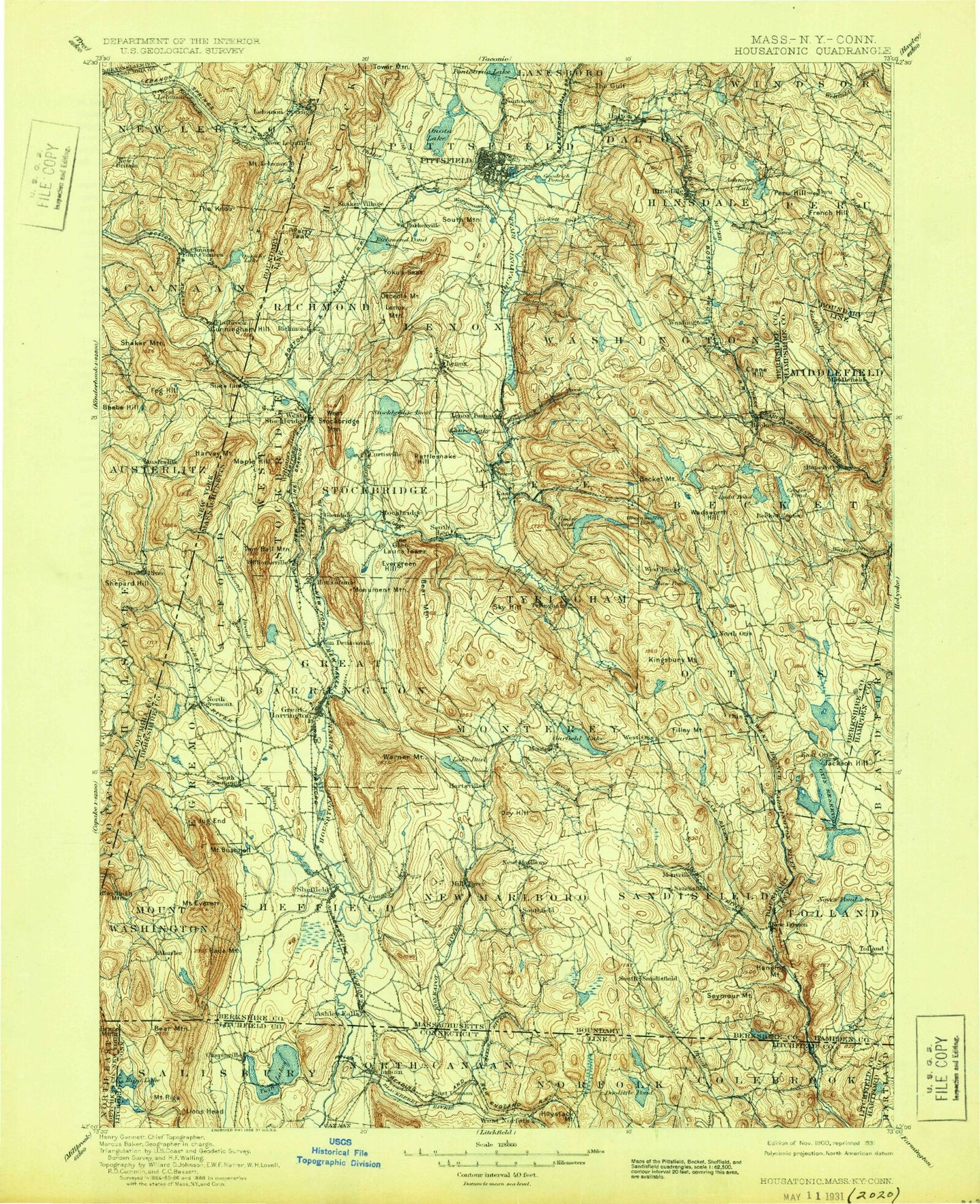
Historic 1900 Housatonic Massachusetts 30'x30' Topo Map
Couldn't load pickup availability
Historical USGS topographic map of Housatonic in the state of Massachusetts. Scale: 1:125000. Print size: 17" x 24"
This map was published in 1900 and is in the following counties: Berkshire, Columbia, Dutchess, Hampden, Hampshire, Hartford, Litchfield, Rensselaer.
The map contains contour lines, roads, rivers, towns, streams, and lakes. Printed on high-quality waterproof paper with UV fade-resistant inks.
Contains the following named places: Colebrook River Lake, Ginger Creek, Mount Prospect, North Brook, Sages Ravine, Belcher Square, Day Mountain, North Egremont, Tully Mountain, The Pinacle, Beartown State Forest, Bates Memorial State Park, Pittsfield State Forest, Osceola Park, Clapp Park, Wahcohah Park, Otis Ridge Ski Area, Becket State Forest, Middlefield State Forest, Pittsfield State Watershed Area, October Mountain State Forest, Schermerhorn Park, Tanglewood, Peru State Wildlife Management Area, East Mountain State Forest, Pontoosuc Park, Lenox House Country Shops, The Center at Lenox, The Pittsfield Plaza, The Fair Shopping Center, A-Z Shopping Center, Allendale Shopping Center, Pittsfield Mall, Cold Spring Campground, Camp Overflow, Camp Nawaka, American Legion Park, Wahconah County Club, Ponterril, Peru State Forest, YMCA Camp, Jayson Camp, Camp Glenmere, Springside Park, Deming Park, Brattle Brook Park, Berkshire Hills Country Club, Butternut Ski Area, United States Fish Hatchery, Monument Mountain Reservation, Wild Cat Trail, Bousquet Ski Area, Greenock Country Club, Coolidge Playground, Pittsfield Country Club, Taconic Skyline Trail, Turner Trail, Brickhouse Mountain Trail, Camp Stevenson, Camp Kingsmont, Burbank Park, Catamount Ski Area, Battlesite Monument, Crane Lake Camp, Northrop Trail, Indian Trail, Elbow Trail, Victory Lake Dam, Cookson Dam, Pelton Dam, Pelton Reservoir, Riiska Brook Dam, Cranberry Pond Dam, Thousand Acre Site Number 1 Dam, Thousand Acre Swamp Reservoir, Plantain Pond Dam, Windemere Lake Reservoir, Windemere Lake Dam, Garret Dam, Lee Pond Brook Reservoir, Mirror Lake Dam, Clam River Watershed Dam, Clam River Watershed Reservoir, North Silver Lake Reservoir, North Silver Lake Dam, York Lake Dam, Lost Wilderness Lake Southern Dam, Berkshire Trout Pond, Lost Wilderness Lake, Lost Wilderness Lake Northern Dam, Noyes Pond Dam, Guilder Pond Dam, Atwater Pond Dam, Wards Pond Dam, Peyser Dam, Combes Pond, Mill Pond Dam, West Lake Dam, Harnett Pond Dam, Abbey Lake Dam, Threemile Pond, Threemile Pond Dam, Clam Lake Dam, Clam Lake Reservoir, Morley Swamp Reservoir, Morley Swamp Dam, Gleason Pond Dam, Mill Pond Dam, Otis Reservoir Dam, Lower Spectacle Pond Dam, Stedman Pond Dam, Gilder Pond Dam, Upper Spectacle Pond Dam, Stevens Pond Dam, Royal Pond Dam, Benton Brook Reservoir, Camp Sequena Dam, Lake Garfield Dam, Prospect Lake Dam, Benedict Pond Dam, Barbieri Reservoir, Barbieri Dam, Long Pond Dam, Hayes Pond Dam, Steadman Pond Dam, White Lily Pond Dam, Watson Pond Dam, Long Pond Dam, Hayden Pond Dam, Berle Dam, Berle Pond, Shaker Pond Dam, Housatonic River Reservoir, Rising Paper Company Dam, Indian Lake Dam, Indian Lake Reservoir, Robin Hood Lake Dam, Round Pond Dam, Little Robin Hood Lake Dam, Long Bow Lake, Goose Pond Dam, Higley Brook Dam, Willow Mill - Hurlbut Dam, Housatonic River Reservoir, Murray Pond Dam, Chimney Corners Pond Dam, Chimney Corners Pond, Palmer Brook Reservoir, Palmer Brook Dam, Housatonic River Reservoir, Glendale Dam, Greenwater Pond Dam, Rudd Pond North Dam, Center Pond Dam, Yokum Pond Dam, Buckley Dunton Lake Dam, Laurel Lake Dam, Finerty Pond Dam, Lake Averic Dam, Columbia Mill Dam, Housatonic River Reservoir, Stockbridge Bowl Dam, Leahy Upper Reservoir Dam, Card Pond Dam, Shaker Mill Pond Dam, Belmont Reservoir Dam, Ashmere Lake Dam, Cleveland Brook Reservoir Dam, East Branch Housatonic River Reservoir, Old Berkshire Mill Dam, Government Mill Dam, Bel Air Dam, West Branch Housatonic River Reservoir, Lower Pecks Pond Dam, Byron Weston Dam, Onota Lake Dam, Pontoosuc Lake Dam, Windsor Reservoir Dam, Egypt Reservoir Dam, Otis Ridge, Newsboy Statue, Cookson State Forest, Umpachene Falls, Bartholomews Cobble, Eastover, Oak n' Spruce Village, Kennedy Park, Berkshire Gardens Center, Berkshire Market Village, Stritch Sculpture Garden, Canoe Meadows Wildlife Sanctuary, Butternut Basin, Mud Pond, Free Quarter, Osceda Mountain, Wahconah Falls State Park, Peru Wildlife Management Area, Hinsdale Flats Wildlife Management Area, George L Darey Wildlife Management Area, Sackett Brook Park, Memorial Park, Pontoosuc Lake Country Club, Mount Washington State Forest, Berkshire County, Felton Lake Brook, Mahican Brook, Newton Brook, Duck Pond Brook, Shadow Brook, Abbey Hill, Abbey Swamp, Adams Junction, Agawam Brook, Agawam Lake, Alander, Alford, Alford Brook, Alum Hill, Angerman Swamp, Ashley Brook, Ashley Falls, Ashley Hill Brook, Ashley Lake, Mount Ashley, Ashley Reservoir, Atwater Pond, Lake Averic, Baldhead, Bald Top, Baldwin Brook, Baldwin Hill, Baldy Mountain, Barkerville, Barnum Street Swamp, Barret Hill, Barry Hill