MyTopo
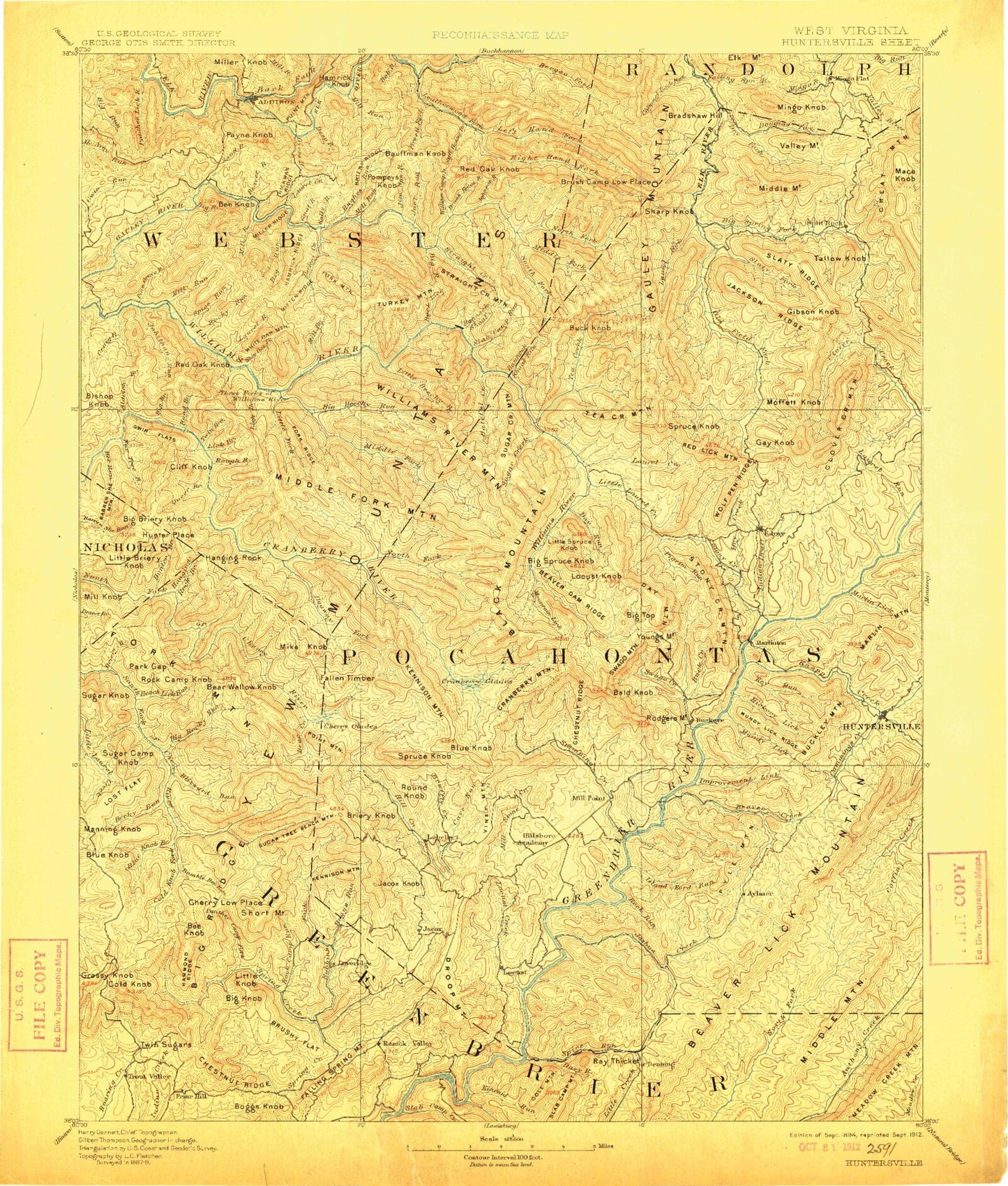
Historic 1894 Huntersville West Virginia 30'x30' Topo Map
Couldn't load pickup availability
Historical USGS topographic map of Huntersville in the state of West Virginia. Scale: 1:125000. Print size: 17" x 24"
This map was published in 1894 and is in the following counties: Greenbrier, Nicholas, Pocahontas, Randolph, Webster.
The map contains contour lines, roads, rivers, towns, streams, and lakes. Printed on high-quality waterproof paper with UV fade-resistant inks.
Contains the following named places: Pocahontas County, Webster County, Indian Draft, Buck and Doe Trail, Airport Hill, Alder Lick Run, Aldrich Branch, Allen Run, Armstrong Run, Arrowhead Trail, Ash Beetree Hollow, August, Back Fork Elk River, Bald Knob, Baldwin Branch, Ballard Mountain, Bannock Shoals Run, Barlow Top, Barrenshe Trail, Baughman Run, Bear Branch, Bear Pen Run Trail, Bear Run, Bear Run, Bear Run Trail, Beard, Beard Lick Run, Beartown State Park, Beartree Run, Beaver Creek, Beaver Creek Trail, Beaver Lick Mountain, Beaver Run, Beaver Trail, Beaverdam Run, Becky Run, Bee Knob, Bee Knob, Bee Run Trail, Beech Lick Run, Beechy Run, Bergoo Creek, Beverly Fork, Big Beechy Trail, Big Bull Hill, Big Draft Run, Big Glady Run, Big Laurel Creek, Big Lick Run, Big Ridge, Big Ridge, Big Ridge, Big Run, Big Run, Big Run, Big Run, Big Run, Big Run, Big Run, Big Run, Big Run, Big Spring Fork, Big Spruce Knob, Big Swag Run, Bill Knob, Billy Branch, Birchlog Run, Birchlog Trail, Black Mountain Run, Blackhole Run, Blazed Fork, Blizzard Run, Blue Knob, Blue Knob Branch, Blue Lick Run, Boggs Knob, Boggs Run, Bolair, Bradshaw Hill, Bridge Creek, Bridger Mountain, Briery Knob, Briery Knob, Briery Run, Browns Creek, Bruffey Creek, Brush Fence Run, Brush Lick Run, Brushy Flat, Buck Ridge, Buckeye Trail, Buckley Mountain Trail, Bucks Run, Bull Run, Bumblebee Run, Burnside Ridge, Burnsides, Burr Valley, Buzzard Ridge, Calvin Price State Forest, Camel Branch, Camel Branch, Camp 29 Run, Camp Caesar, Carpenter Run, Carr Branch, Cashcamp Run, Cave Run, Charles Creek, Charley Run, Cheat Mountain, Cherry Low Place, Chestnut Flat, Chestnut Flats, Chestnut Ridge, Chicken House Run, Coal Fork, Coal Run, Coats Run, Cold Knob, Cold Knob Fork, Cold Knob Mountain, Cold Run, Columbia Sulphur Springs, Coon Run, Cordova, Cow Pasture Trail, Craig Run, Cranberry Campground, Cranberry Glades, Cranberry Glades Overlook, Cranberry Mountain, Cranberry Ridge, Crooked Fork, Crowser Hollow, Cub Ridge, Cummings Creek, Cup Run, Daniel Ridge, Darnell Run, Davy Run, Day Mountain, Day Run, Day Run Campground, Deacon Run, Dean Hollow, Deep Run, Devils Backbone, Devils Garden, Dilley Run, Dilly Fork, Dogway Camping Shelter, Dogway Fork, Douglas Fork, Downy Run, Droop Mountain, Droop Mountain Battlefield State Park, Dry Creek, Dry Creek, Dry Fork, Dry Run, Dry Run, Drybed Run, Dyers Run, Eagles Camp, Eagles Camp Trail, Elbow Run, Elklick Run, Ellis Knob, Epling Run, Excelsior, Fallen Timber Run, Fallen Timber Run, Falling Spring Run, Falls of Hills Creek, Fitzwater Branch, Flat Ridge, Fork Mountain, Fork Mountain Trail, Fork Ridge, Forks of Cranberry Trail, Fourmile Run, Foxtree Run, Friars Hole, Friel Run, Frosty Gap, Frosty Gap Trail, Gauley Divide, Gauley Mountain, Gauley Mountain Trail, Gilden Hollow, Glade Run, Golden, Goose Hollow, Griffin Run, Hacking Run, Halfway Run, Hammond Run, Hamrick Ridge, Hamrick Run, Handley Wildlife Management Area, Hanging Rock Branch, Hanging Rock Trail, Hateful Run, Hatten Run, Hell for Certain Branch, Hickman Hollow, Hills Creek, Hillsboro, Hock Knob, Holcomb Run, Honey Moon Trail, Horrock, Houselog Run, Hughes Run, Hunters Run, Huntersville, Hunting Run, Improvement Lick Run, Island Lick Run, Jacox, Jakes Run, Joe Run, John Lee Hollow, Johnson Hollow, Johnson Run, Jonathan Run, Julia, Kee Flats, Kee Hollow, Kennison Mountain Trail, Kennison Mountains, Kennison Run, Kincaid Run, Kingfisher Creek, Kens Creek