MyTopo
Historic 1892 Huntington West Virginia 30'x30' Topo Map
Couldn't load pickup availability
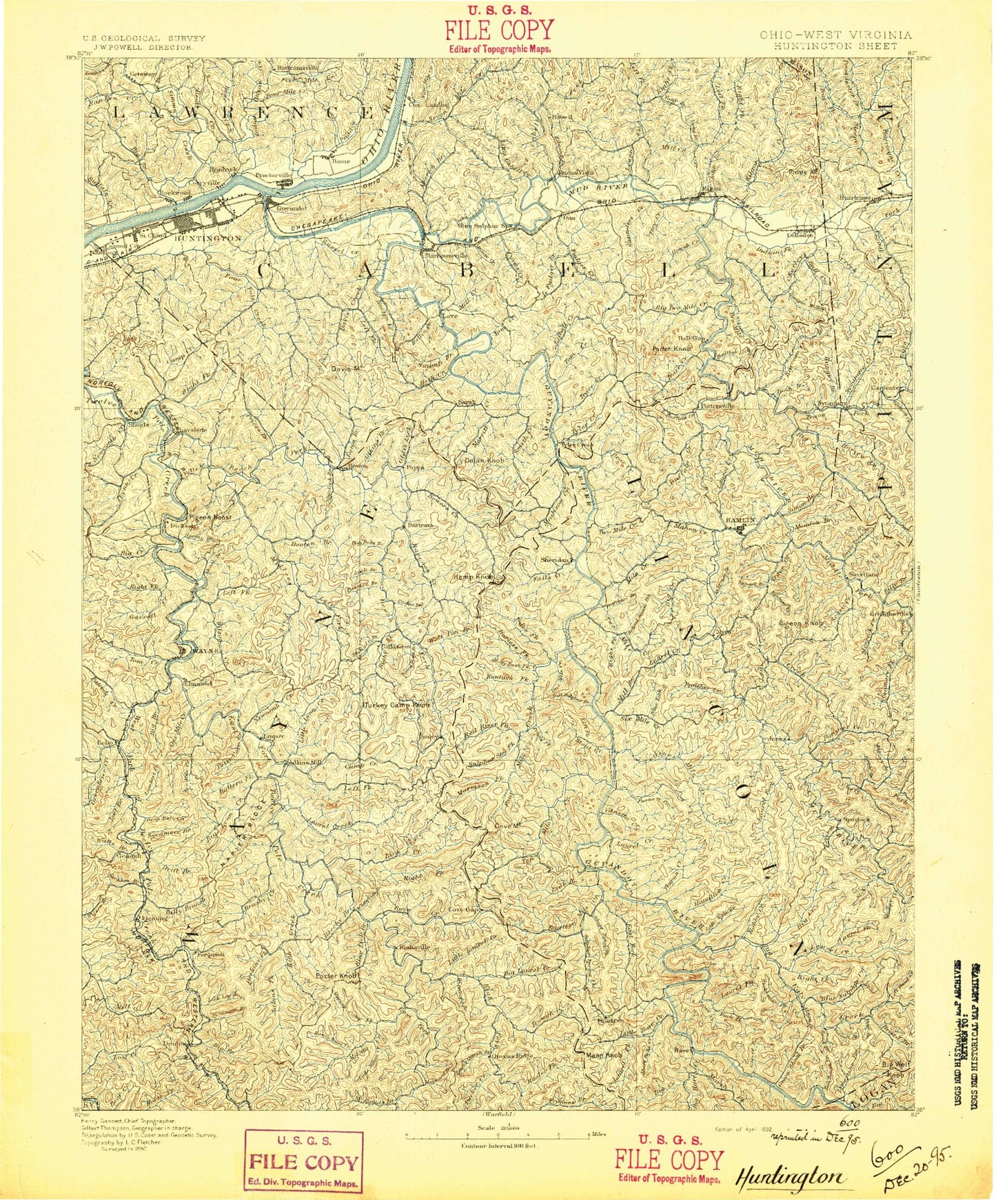
Historical USGS topographic map of Huntington in the state of West Virginia. Scale: 1:125000. Print size: 17" x 24"
This map was published in 1892 and is in the following counties: Cabell, Lawrence, Lincoln, Logan, Mason, Putnam, Wayne.
The map contains contour lines, roads, rivers, towns, streams, and lakes. Printed on high-quality waterproof paper with UV fade-resistant inks.
Contains the following named places: Aarons Creek, Abbott Branch, Alum Fork, Alum Fork, Alum Rock Branch, Amp Branch, Apple Orchard Branch, Arm and Hammer Branch, Asbury Hollow, Atenville, Baber, Back Fork, Baker Hollow, Ball Creek, Balls Gap, Barker Hollow, Bartram Branch, Bates Branch, Battern Fork, Bayles Hollow, Bear Branch, Bear Creek, Bear Knob, Bearwallow Branch, Bearwallow Branch, Beaver Pond Branch, Bee Branch, Bee Branch, Bee Branch, Beech Fork, Beech Fork Lake, Beechy Branch, Bell Hollow, Ben Haley Branch, Benny Branch, Big Branch, Big Branch, Big Branch, Big Branch, Big Branch, Big Branch, Big Branch, Big Branch, Big Branch, Big Branch, Big Branch, Big Cabell Creek, Big Creek, Big Creek, Big Creek, Big Creek, Big Creek, Big Fork Sand Creek, Big Gut Branch, Big Harts Creek, Big Hill Hollow, Big Laurel Creek, Big Laurel Creek, Big Twomile Creek, Big Ugly Creek, Bill Frye Branch, Billy Branch, Billy Creek, Bing Gap, Black Oak Gap, Bletcher Brook, Bluelick Branch, Bluelick Branch, Boat Gunwale Hollow, Bob Wetherall Branch, Bobby Creek, Booten Creek, Booth Branch, Booth Branch, Bowen Creek, Branchland, Bridge Branch, Broad Branch, Browns Branch, Brumfield Branch, Brush Creek, Brush Creek, Bryant Fork, Buck Branch, Buck Branch, Buck Fork, Buckeye Hollow, Buffalo Creek, Burns Creek, Burrel Hollow, Butler Branch, Buzzard Creek, Calf Branch, Camp Arrowhead, Camp Asbury, Camp Branch, Camp Branch, Camp Branch, Camp Creek, Camp Creek, Camp Creek, Camp Dekanawida, Camp Guyandotte, Caney Branch, Canoe Fork, Canoe Tree Fork, Carpers Branch, Carter Branch, Cavill Creek, Cedar Branch, Chaney Fork, Charley Creek, Charley Trace Fork, Cherry Run, Chestnut Oak Creek, Childers Branch, Clymer Creek, Coal Branch, Coal Hollow, Coal Hollow, Coleman Creek, Coon Creek, Coon Creek, Cooper Branch, Cove Creek, Cove Gap, Cow Hollow, Cowhide Creek, Crackersneck Ridge, Crockett Fork, Curry Branch, Cyrus Creek, Dalton Fork, Dalton Fork, Damel Branch, Damel Fork, Daniel Branch, Davis Creek, Davis Fork, Davis Trace Branch, Deadwood Hollow, Deephole Branch, Denison Fork, Devilstrace Branch, Dial Branch, Dick Branch, Dick Fork, Dog Pool Branch, Donathan Branch, Doss Fork, Dotson Branch, Doublelick Branch, Drenner Hollow, Drift Branch, Drum Gap, Dry Branch, Dry Creek, Dry Fork, Dry Run, Dunlow, Durg Frye Hollow, East Fork Fourteenmile Creek, East Fork Twelvepole Creek, East Lynn, East Lynn Lake, Ed Stone Branch, Edds Branch, Edens Branch, Edmonds Branch, Elias Fork, Elkins Branch, Elkins Branch, Elmwood, Fallen Fork, Falls Branch, Falls Branch, Falls Branch, Falls Creek, Ferguson, Ferguson Branch, Ferguson Ridge, Ferrellsburg, Fez Creek, First Fork, Fisher Bowen Branch, Flat Branch, Flat Branch, Flat Branch, Fork Ridge, Fort Branch, Fourmile Creek, Fourteenmile Creek, Fraley Fork, Frances Creek, Frank Branch, Franklin Hollow, Fudges Creek, Furnett Creek, Garrett Creek, Gartin Fork, Geiger Branch, Genoa, Gilkerson Branch, Gilles Branch, Gimlet Hollow, Gobbler Knob, Gordons Branch, Grapevine Branch, Grassy Branch, Grassy Lick, Green Shoals Branch, Green Shoals Mountain, Greenbrier Creek, Grindstone Hollow, Guyandotte, Guyandotte River, Hager Fork, Hamilton Creek, Hamlin, Hampton Creek, Haneys Branch, Hanging Rock Branch, Hannah Hollow, Harless Branch, Harless Fork, Harts, Harts Pond, Harvey Creek, Harvey Fork, Harveytown, Heath Creek, Heck Branch, Henry Smith Branch, Hense Branch, Hickory Gap, Hisey Fork Fourpole Creek