MyTopo
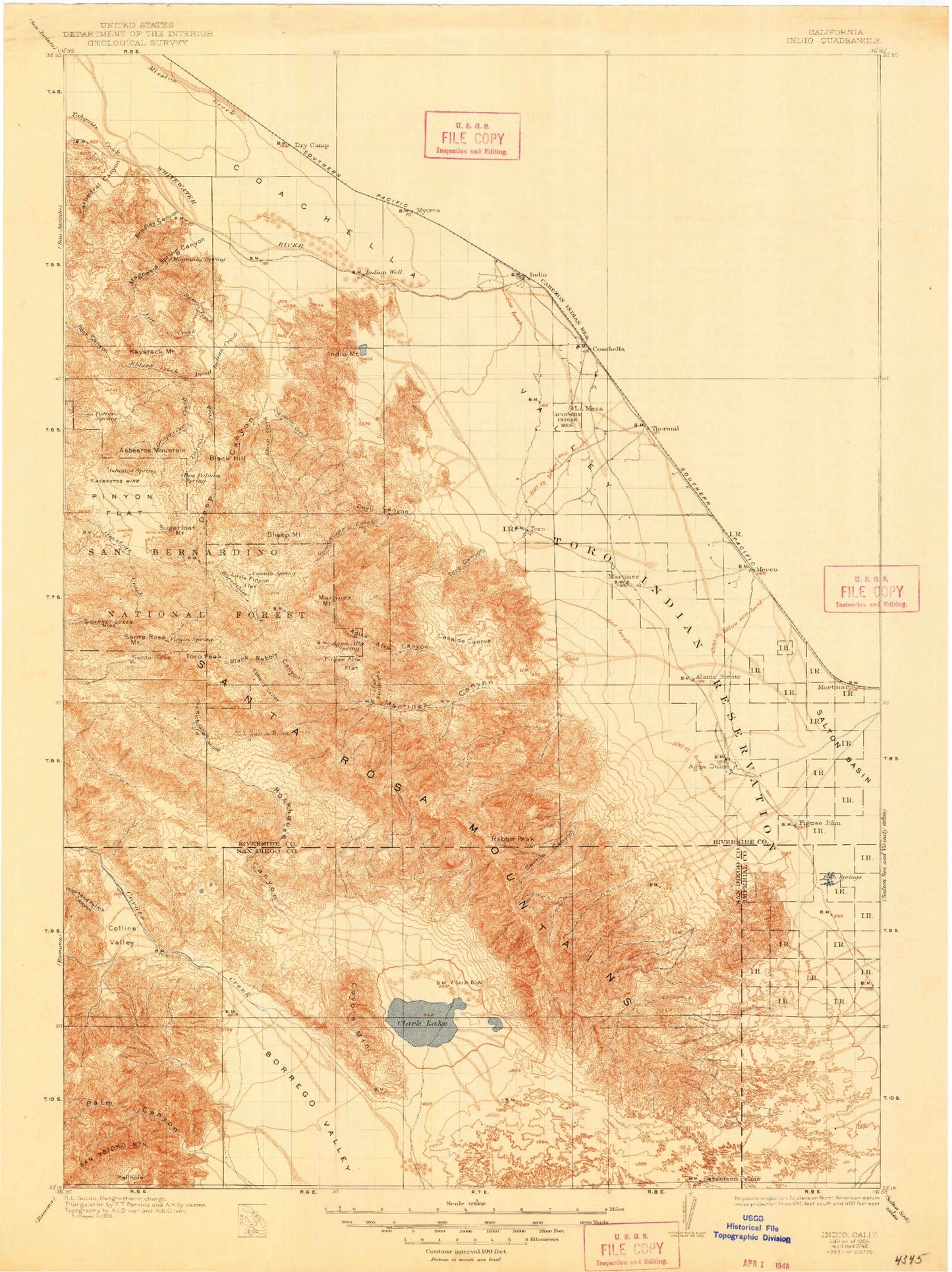
Historic 1904 Indio California 30'x30' Topo Map
Couldn't load pickup availability
Historical USGS topographic map of Indio in the state of California. Scale: 1:125000. Print size: 18" x 24"
This map was published in 1904 and is in the following counties: -.
The map contains contour lines, roads, rivers, towns, streams, and lakes. Printed on high-quality waterproof paper with UV fade-resistant inks.
Contains the following named places: Alcoholic Pass, Anza-Borrego Desert State Park Headquarters, Aqueduct Jeep Trail, Asbestos Mine, Augustine Reservation, Barton Canyon, Bennis Bowl, Berdoo Canyon, Borrego Palms Resort, Box Canyon Wash, Calcite Mine, Calcite Road, Clark Lake, Coachella Valley Stormwater Channel, Coachwhip Canyon, Coyote Mountain, Deep Canyon Stormwater Channel, Deering Canyon, Dolomite Mine, East Double Canyon, El Vado Historical Marker, Ella Wash, Fargo Canyon, Fleming Ranch, Fonts Point, Fonts Point Wash, Front Hill Canyon, Galleta Meadows, Garner Wash, Garnet Queen Mine, Hellhole Flat, Henderson Canyon, Hidden Palm Canyon, Hidden Valley, Horsethief Creek, Indian Creek, Indio Canyon, Indio Mountain, Inspiration Point, Little Clark Lake, Little Pinyon Flat, Martinez Canyon, Natural Rock Tanks, North Fork Palm Wash, Oasis, Oasis Lateral, Ocotillo Flat, Painted Canyon, Palo Verde Canyon, Palo Verde Ranger Station, Panorama Outlook, Pegleg Smith Historical Marker, Pinyon Flat Campground, Pushawalla Canyon, Rainbow Rock, Rancho De Anza, Rattlesnake Canyon, Rockhouse Canyon, Rockhouse Trail, Sandy Korner, Seventeen Palms, Sheep Canyon, Sheep Canyon Ranger Station, Sheep Mountain, Short Wash, Smoke Tree Canyon, Smoke Tree Wash, South Fork Palm Wash, Thermal, Thermal Canyon, Thousand Palm Canyon Wash, Thousand Palms Canyon, Thousand Palms Dry Camp Siding, Toro Canyon, Toro Peak, Torres, Travertine Palms Wash, Truckhaven Trail, Twenty-Nine Palms Reservation, Valley of the Thousand Springs, Villager Peak, Vista del Malpais, Vista del Malpais Wash, West Berdoo Canyon, West Double Canyon, Wonderstone Wash, Yellow Spots Canyon, Indio Hills, Eisenhower Mountain, Toro, Taylor, Agua Alta Canyon, Pinyon Flat, Surprise Valley, Borrego Palm Canyon, Clark Valley, Indian Canyon, Palm Mesa, Wasteway Number Two, Wasteway Number Three, Torres-Martinez Reservation, Alder Canyon, Anza Trail, Asbestos Mountain, Bear Creek, Black Hill, Black Rabbit Canyon, Box Canyon, Bradley Canyon, Buck Ridge, Butler Canyon, Cactus Spring Trail, Carrizo Creek, Casa de Cuerva, Cat Creek, Cathedral Canyon, Coachella Valley, Collins Valley, Cougar Canyon, Coyote Canyon, Coyote Creek, Dead Indian Creek, Deep Canyon, Devil Canyon, Dry Wash, Ebbens Creek, Ebbens Valley, Grapevine Creek, Guadalupe Creek, Haystack Mountain, Jackass Flat, Lower Willows, Magnesia Spring Canyon, Martinez Mountain, Middle Fork Borrego Palm Canyon, Middle Willows, Nicholias Canyon, North Fork Borrego Palm Canyon, Palm Canyon Wash, Palm Valley Stormwater Channel, Pinyon Alta Flat, Ramon Creek, Rockhouse Canyon, San Ysidro Mountain, Santa Rosa Mountains, Sheep Canyon, Sheep Creek, Shumway Ranch, South Fork Salvador Canyon, South Fork Sheep Canyon, Tahquitz Canyon, Tahquitz Creek, Whitewater River, Yucca Valley, Big Horn Overlook, Santa Rosa Campground, Borrego Springs, Coachella, Indio, Mecca, Palm Desert, Bermuda Dunes Country Club, Borrego Valley Substation, De Anza Desert Country Club, Early Indian Fish Traps, El Dorado Golf Course, Indian Wells Golf Course, Tamarisk Country Club, Thunderbird Country Club, Salvador Canyon, Skeleton Canyon, South Fork Borrego Palm Canyon, Cathedral City, Edom, Monkey Hill, Murray Hill, Thousand Palms, Biskra Palms, Cahuilla Hills, Coolidge Springs, Hidden Palms, Indian Wells, Indianhead, La Quinta, Macomber Palms, Martinez, Pinyon Pines, One Hundred Palms, Pinyon Crest, Point Happy, Pushawalla Palms, Rabbit Peak, Rancho Mirage, Ribbonwood, Salton Sea Beach, Santa Rosa Mountain, Travertine Rock, Valerie, Willis Palms, East Side Detention Dike Number 1 Dam, East Side Detention Dike Number 2 Dam, West Side Detention Dike Number 2 Dam, West Side Detention Dike Number 3 Dam, West Side Detention Dike Number 4 Dam, Alpine Village, Hidden Palms State Ecological Reserve, Lake Cahuilla County Park, Santa Rosa Spring Campground, Spring Crest, Stump Spring Campground, Desert Shores, Salton Sea Service Station, Oasis Maintenance Station, Oriols Service Station, Brinniger Ranch, Oliver Ranch, Borrego Palm Canyon Campground, Travertine Palms, Torres Martinez Indian Reservation Headquarters, Hunter Palms Ranch, McPherson Ranch, Rancho Las Arenas, Snyder Date Gardens, Agua Caliente Park, Caliente Sands, Cathedral Canyon Country Club, Cathedral City Marketplace Shopping Center, Cathedral City Shopping Plaza Shopping Center, Cathedral Plaza Shopping Center, Cathedral Village Shopping Center, Century Park, Century Plaza Shopping Center, Date Palm Shopping Center, De Anza Country Club, Dinah Shore Golf Course, Mission Hills Country Club