MyTopo
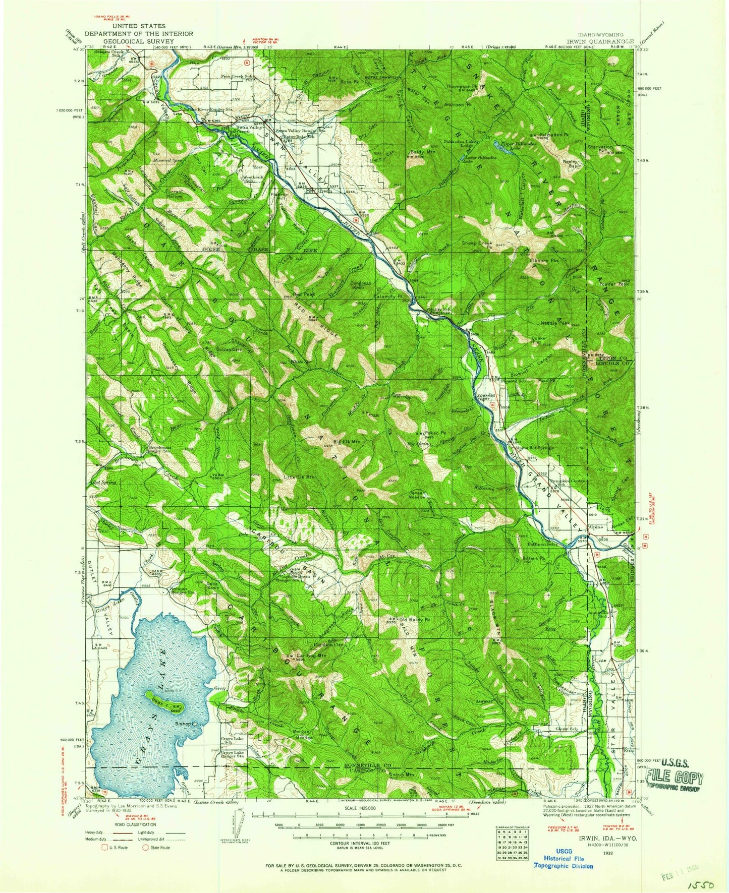
Historic 1932 Irwin Idaho 30'x30' Topo Map
Couldn't load pickup availability
Historical USGS topographic map of Irwin in the state of Idaho. Scale: 1:125000. Print size: 18" x 24"
This map was published in 1932 and is in the following counties: Bonneville, Caribou, Lincoln, Teton.
The map contains contour lines, roads, rivers, towns, streams, and lakes. Printed on high-quality waterproof paper with UV fade-resistant inks.
Contains the following named places: Alpine Campground, Anderson Gulch, Atkinson Peak, Austin Canyon, Mount Baird, Bald Mountain, Bald Mountain Guard Station, Baldy Canyon, Baldy Mountain, Barnes Creek, Bear Canyon, Bear Creek, Bear Island, Bear Wallow Canyon, Beaver Ridge, Big Dry Canyon, Big Elk Creek, Big Elk Creek Campground, Big Elk Mountain, Big Spring Creek, Bilk Creek, Bishop Island, Bitters Creek, Bitters Peak, Black Canyon, Black Mountain, Blacktail Canyon, Booth Canyon, Box Canyon, Box Canyon, Box Canyon Creek, Bridge Creek, Burns Creek, Butler Canyon, Cabin Creek, Calamity Guard Station, Calamity Point, Calf Hollow, Camp Creek, Camp Creek, Camp Creek, Camp Little Lemhi, Camp Ta-Man-a-Wis, Canary Canyon, Caribou Basin, Caribou Mountain, Caribou Range, Chaparral Hollow, Chicken Ridge, Chicken Spring Canyon, City Creek, Clark Creek, Clarks Cut, Clear Creek, Comb Creek, Commissary Ridge, Conant Valley, Conglomerate Canyon, Congress Knob, Corral Canyon, Corral Canyon, Corral Creek, Coyote Hollow, Cromwell Canyon, Currant Creek, Currant Creek Guard Station, Currant Hollow, Dead Man Canyon, Deadhorse Ridge, Deadman Creek, Deep Creek, Deer Creek, Deer Flat, Della Basin, Dry Canyon, Dry Canyon, Dry Canyon, Dry Elk Canyon, Dry Gulch, Dry Hollow, Eagle Creek, East Fork Fall Creek, East Fork Palisades Creek, Echo Canyon, Edwards Creek, Elbow Canyon, Elk Creek, Evergreen Mine, Fall Creek, Fall Creek Basin, Fall Creek Falls, Falls Campground, First Canyon, Fish Creek, Flag Knoll, Flatiron Hollow, Fourth of July Ridge, Garden Creek, Gibson Creek, Granite Creek, Gravel Creek, Grays Lake National Wildlife Refuge, Grouse Creek, Haskin Creek, Hawthorn Hollow, Hell Creek, Hoffman Campground, Holland Canyon, Home Ridge, Horse Canyon, Horse Creek, Hubler Creek, Ice Cove Canyon, Indian Camp Hollow, Indian Creek, Indian Creek, Iowa Creek, Irwin Canyon, Jackknife Creek, Jensen Creek, Jensen Meadow, Keenan Creek, King Creek, Kirk Creek, Lake Canyon, Landslide Creek, Lightning Ridge, Limekiln Canyon, Little Baldy Canyon, Little Baldy Mountain, Little Bear Canyon, Little Box Canyon, Little Box Canyon, Little Currant Hollow, Little Dry Canyon, Little Elk Creek, Little Palisades Peak, Little Sheep Creek, Lone Pine Ridge, Long Canyon, Long Gulch, Lorian Canyon, Lost Spring Canyon, Lower Palisades Lake, Luthi Canyon, McCoy Creek, McCoy Creek Campground, McNeel Creek, Milk Creek, Mill Canyon, Miller Creek, Miners Delight Creek, Monte Cristo Mine, Morgan Meadow, Muddy Creek, Newswander Canyon, North Fork Bear Creek, North Fork Eagle Creek, North Fork Indian Creek, North Fork Palisades Creek, North Fork Rainey Creek, Oakden Canyon, Old Baldy Peak, Palisades Bench, Palisades Creek, Palisades Creek Campground, Palisades Dam, Palisades Peak, Papoose Creek, Paradise Basin, Pat Canyon, Paul Peak, Pine Creek, Pine Creek, Pine Creek Bench, Poison Creek, Poker Peak, Pole Creek, Porcupine Creek, Pritchard Creek, Quaker Flat, Rainey Creek, Rash Canyon, Raymond Creek, Red Ridge, Red Spring Creek, Road Canyon, Rocky Canyon, Rocky Ridge, Roller Canyon, Ross Peak, Russell Creek, Salt River, Sawmill Canyon, Sawmill Creek, Sheep Creek, Sheep Creek Peak, Shurtliff Canyon, Skull Canyon, Skunk Canyon, Small Creek, Smith Canyon, Snake River Ranger Station, South Fork Bear Creek, South Fork Fall Creek, South Fork Indian Creek, South Fork Rainey Creek, Spaulding Basin, Spring Canyon, Spring Creek, Spring Creek, Spring Creek Campground, Spring Run Canyon, Squaw Creek, Squaw Creek, Squaw Creek Sawmill, Sulphur Bar Creek, Swan Valley, Tag Alder Creek, Taylor Creek, Thompson Peak, Tincup Campground, Tincup Creek, Trail Creek, Trap Creek, Trout Creek, Upper Palisades Lake, Vacation Canyon, Van Creek, Van Point, Warm Springs Creek, Water Canyon, Waterfall Canyon, West Fork Fish Creek, West Fork Squaw Creek, Williams Creek