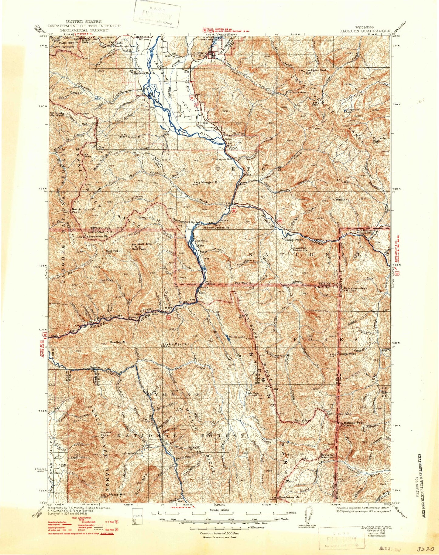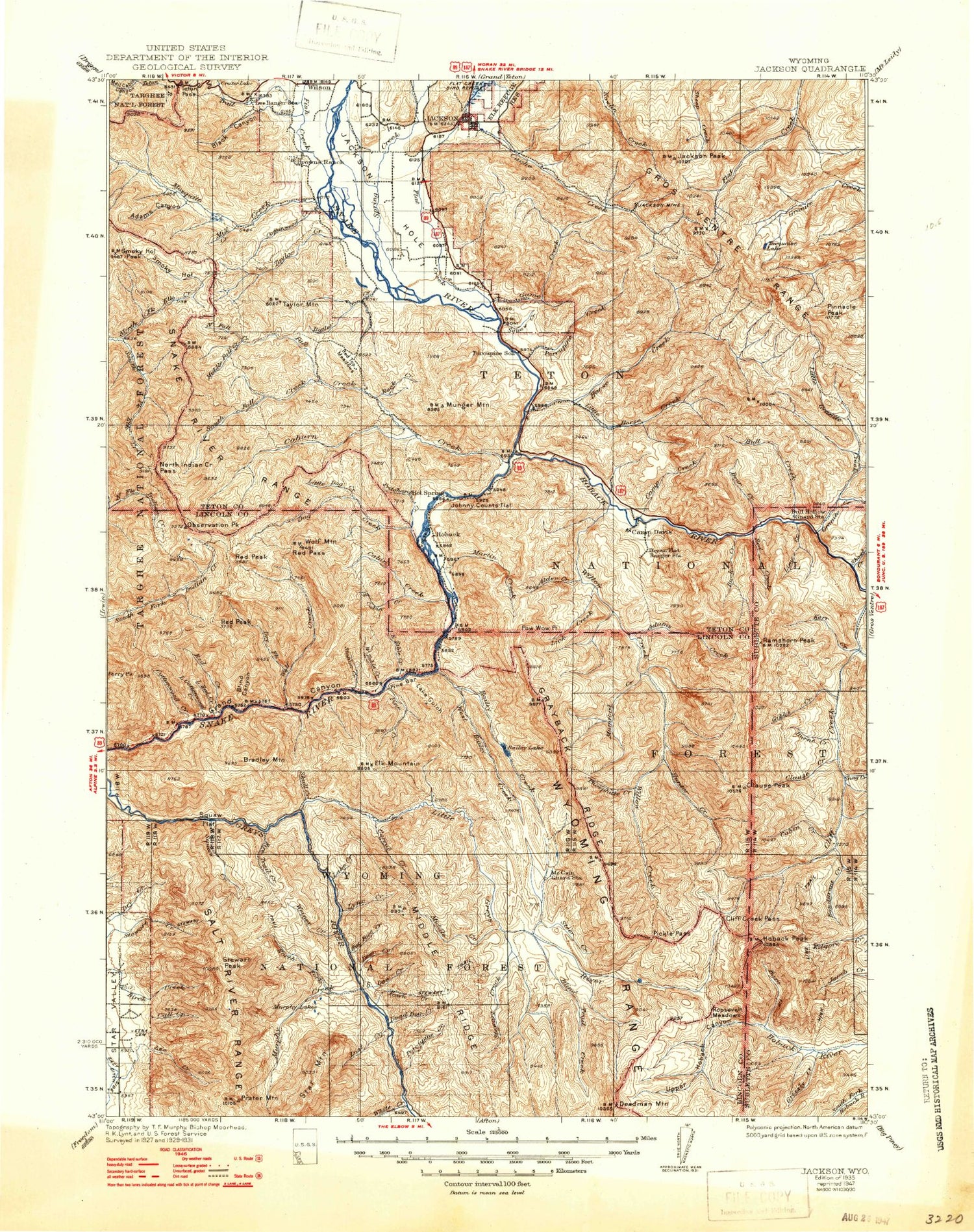
MyTopo
Historic 1935 Jackson Wyoming 30'x30' Topo Map
Couldn't load pickup availability
Historical USGS topographic map of Jackson in the state of Wyoming. Scale: 1:125000. Print size: 17" x 24"
This map was published in 1935 and is in the following counties: Lincoln, Sublette, Teton.
The map contains contour lines, roads, rivers, towns, streams, and lakes. Printed on high-quality waterproof paper with UV fade-resistant inks.
Contains the following named places: Rocky Mountains, Burnt Creek, Cabin Creek, Camp Creek, Camp Creek Saddle, Camp Davis, Clause Creek, Clause Peak, Coles Canyon, Dead Dog Creek, Deer Creek, Deer Creek, Deer Creek Guard Station, Fawn Creek, Game Creek, Gibbs Creek, Gin Pole Draw, Hoback Junction, Hot Foot Creek, Jackson Mine, Jackson Peak, Kerr Creek, Lake Creek, Lost Creek, Lost Lake, Lynx Creek, Murphy Lakes, Noker Mine Draw, Nowlin Peak, Palmer Creek, Porcupine Creek, Porcupine Creek, Ramshorn Peak, Salt Lick Draw, Sob Creek, Sourdough Creek, South Doe Creek, Squaw Creek, Star Peaks, Stump Lake, Woods Canyon, Lynx Creek Campground, Murphy Creek Campground, Nowlin Creek, Adams Canyon, Adams Creek, Alder Creek, Aspen Hollow, Bailey Creek, Bailey Lake, Bare Creek, Bare Hole, Battle Mountain, Bear Creek, Beaver Dam Canyon, Beaver Mountain, Black Canyon, Blackman Creek, Blind Canyon, Blind Trail Creek, Blue Bell Creek, Bohnetts Canyon, Bondurant Creek, Boyles Hill, Bradley Mountain, Bridge Campground, Buck Creek, Bull Hollow, Bureau of Public Roads Camp, Burnt Timber Canyon, Butler Creek, Cabin Creek, Cabin Creek, Cabin Creek Campground, Cache Creek, Cache Peak, Call Creek, Cascade Creek, Cliff Creek Falls, Cliff Creek Pass, Coburn Creek, Cottonwood Creek, Cottonwood Creek, Cow Camp Creek, Cow Creek, Crane Creek, Crater Lake, Cream Puff Peak, Deadhorse Canyon, Deadhorse Peak, Deadman Mountain, Dells Canyon, Dog Creek, Dry Fork, Dry Gulch, Dry Wash, East Gros Ventre Butte, East Table Creek, East Table Creek Campground, Elk Gulch, Elk Mountain, Fall Creek, Fire Box Creek, Fire Trail Creek, First Creek, Fish Creek, Flat Creek, Forks Campground, Fourth Creek, Fullturn Creek, Georges Canyon, Glory Slide, Goodwin Lake, Grand Canyon, Granite Creek, Granite Highline Trail, Grayback Ridge, Green Knoll, Grizzly Basin, Grizzly Creek, Halfturn Creek, Higby Creek, High Line Trail, Hoback, Hoback Campground, Hoback Peak, Hoback River, Hole-in-the-Wall Creek, Horse Heaven Meadows, Horsethief Canyon, Hunter Creek, Indian Peak, Iron Rim Creek, Johnny Counts Flat, Keyser Creek, Kozy Campground, Lake Basin, Lake Gulch, Lee Guard Station, Leeks Canyon, Lick Creek, Lime Creek, Little Cliff Creek, Little Cottonwood Creek, Little Dog Creek, Little Granite Creek, Little Greys River, Little Horse Creek, Little Horsethief Canyon, Little Jenny Lake, Little Red Creek, Long Draw, Marshall Creek, Martin Creek, McCain Creek, McCain Guard Station, Middle Creek, Mill Creek, Mill Creek, Moose Gulch, Mosquito Creek, Mud Pass, Mumford Creek, Munger Mountain, Murphy Creek, North Fork Elk Creek, North Fork Fall Creek, North Fork Horse Creek, North Fork Mosquito Creek, North Fork Murphy Creek, North Fork Trail Creek, North Indian Creek Pass, Oat Canyon, Observation Peak, Open Canyon, Phosphate Creek, Pickle Pass, Pine Bar, Pine Creek, Pinnacle Peak, Placer Creek, Poison Creek, Poison Hollow, Pole Canyon, Pow Wow Point, Prater Mountain, Pritchard Creek, Pritchard Pass, Pup Creek, Red Creek, Red Creek, Red Pass, Red Peak, Red Top Meadows, Rimrock Ranch, Rock Creek, Roos Creek, Roosevelt Meadows, Sandy Marshall Creek, Table Mountain, Sawpit Creek, Second Creek, Sheep Gulch, Shepard Creek, Shoal Creek, Skull Creek, Smith Canyon, Smoky Hollow, Smoky Hollow Peak, Snag Creek, South Cabin Creek, South Fork Elk Creek, South Fork Fall Creek, South Fork Little Greys River, South Park, Spring Creek, Squaw Creek, Squaw Creek, Squaw Flat, Squaw Fork Canyon, Squirrel Creek, Station Creek, Station Creek Campground, Steer Creek, Stewart Creek, Stewart Peak, Stewart Trail, Taylor Creek, Taylor Mountain, Telephone Pass, Third Creek, Trail Creek, Trail Creek, Trail Creek Ranch, Turquoise Lake, Waterdog Lake