MyTopo
Historic 1893 Jasper Alabama 30'x30' Topo Map
Couldn't load pickup availability
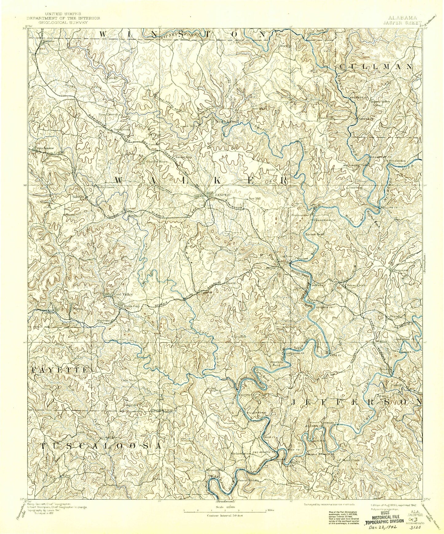
Historical USGS topographic map of Jasper in the state of Alabama. Scale: 1:125000. Print size: 17" x 24"
This map was published in 1893 and is in the following counties: Cullman, Fayette, Jefferson, Tuscaloosa, Walker, Winston.
The map contains contour lines, roads, rivers, towns, streams, and lakes. Printed on high-quality waterproof paper with UV fade-resistant inks.
Contains the following named places: Academy Hill, Aldridge, Allen Ridge, America, Appling Bend, Argo, Artesian Hollow, Bad Branch, Bagley, Baker Creek, Balls Hollow, Bankhead, Banking Grounds, Barner Hollow, Barnes Branch, Barney, Barr Hollow, Bates Creek, Bear Gap Branch, Bear Pen Branch, Bear Pen Mountain, Bee Spring Branch, Ben Vines Gap, Benoit, Bentley Lake, Big Branch, Big Branch, Big Jim Hollow, Big Ridge, Big Ridge, Birmingham Hollow, Biscuit Mountain, Black Branch, Blevins Hollow, Blue Branch, Blue Ridge, Blue Water Creek, Bluff Creek, Bluff Creek Camp, Boldo, Boley Creek, Booker Heights, Boshell Branch, Boshell Hill, Bough Bend, Boyd Creek, Brazeal Branch, Briceston Hollow, Brown Hollow, Bryan, Bryants Creek, Bullbarn Creek, Burnt Cane Creek, Burnwell, Busby Hollow, Bush Tower, Cain Store, Calumet, Cameron, Camp Creek, Camp Oliver, Camp Sumiton, Campbellville, Cane Creek, Cane Creek, Cane Creek, Caney Branch, Cedar Creek, Cedrum, Cedrum Mountain, Chapel Hill, Chapel Hill, Church Hollow, Clark Branch, Clemments Mountain, Clifty Creek, Clinton Branch, Coal Bed Creek, Coal Creek, Coal Creek, Coal Creek, Coal Valley, Coalbed Hollow, Coalbed Hollow, Coke Oven Branch, Coke Oven Hill, Cold Springs, Coon Creek, Coon Creek, Coon Hollow, Cordell Creek, Cordova, Corinth, Corona, County Line Branch, Cow Branch, Cowcumber Hill, Crump Hill, Dark Hollow, Davis Bend, Davis Camp, Dickey Branch, Dilworth, Dipping Vat Hollow, Dividing Ridge, Doctor Harris Spring Branch, Doctors Branch, Doliska, Dooley Mountain, Dora Junction, Double Branch, Dovertown, Downey Branch, Drip Spring Hollow, Drummond, Drummond Bend, Dry Branch, Dry Creek, East Branch Indian Creek, East Fork Clifty Creek, Edgil Branch, Empire, Evans Creek, Falls Creek, Fannys Branch, Fishtrap Branch, Flat Branch, Flat Creek, Flat Creek, Flat Rock Creek, Flatwoods, Flint Ridge, Fourmile Creek, Franklin Bend, Frileys Creek, Frisco Quarters, Frog Ague Creek, Frost Creek, Gaines Hill, Gardiners Gin, Gayosa Mountain, Gibson Hill, Gilmore, Gin Mountain, Gobblers Crossing, Gode Branch, Goodsprings, Gorgas, Gum Suck Hollow, Guthrie Creek, Gutters Branch, Hammonds Shinbone Mountain, Hamner Hollow, Hayes Hill, Hillsdale, Holly Grove, Horse Creek, Horse Creek, Horse Creek, Horseshoe Mountain, Howton Camp, Hull, Hurricane Creek, Hurricane Creek, Indian Creek, Indian Creek, Jane Branch, Japanese Creek, Jasper, Jenkins Branch, Jess Creek, Jess Dunn Hill, Jim Branch, Jim Light Branch, John R Hollow, Keith Branch, Kenney Branch, Kershaw Hollow, Kilgore, Kilgore Branch, Kimbrell Hill, Kisner Slough, Kitty Branch, Lard Creek, Leeann Bend, Leeth Creek, Leeth Hill, Lick Branch, Lick Creek, Lightfoot Branch, Little Blue Water Creek, Little Camp Creek, Little Creek, Little Frog Ague Creek, Little Indian Creek, Little Shoal, Little Shoal Creek, Little White Oak Creek, Little Yellow Creek, Lockhart Hill, Lockhart Hollow, Long Branch, Lorton, Low Gap, Magbee Bend, Mail Route Mountain, Marietta, Martin Branch, Mary Ann Hollow, Mathie Branch, Maxine, McCleskey Hill, McCollum, McDuff Branch, Media, Miller Slough, Miner Hollow, Morgan Creek, Morse Hill, Mount Hope, Mulberry Fork, Mullen Branch, Myers Branch, Nance Hollow, New England Hollow, Nichols Shoals, No Business Creek, North Branch Fourmile Creek, Oakahalla, Old Town Creek, Panther Branch, Parker Branch, Parrish, Patton Hill, Patton Hollow, Pea Ridge