MyTopo
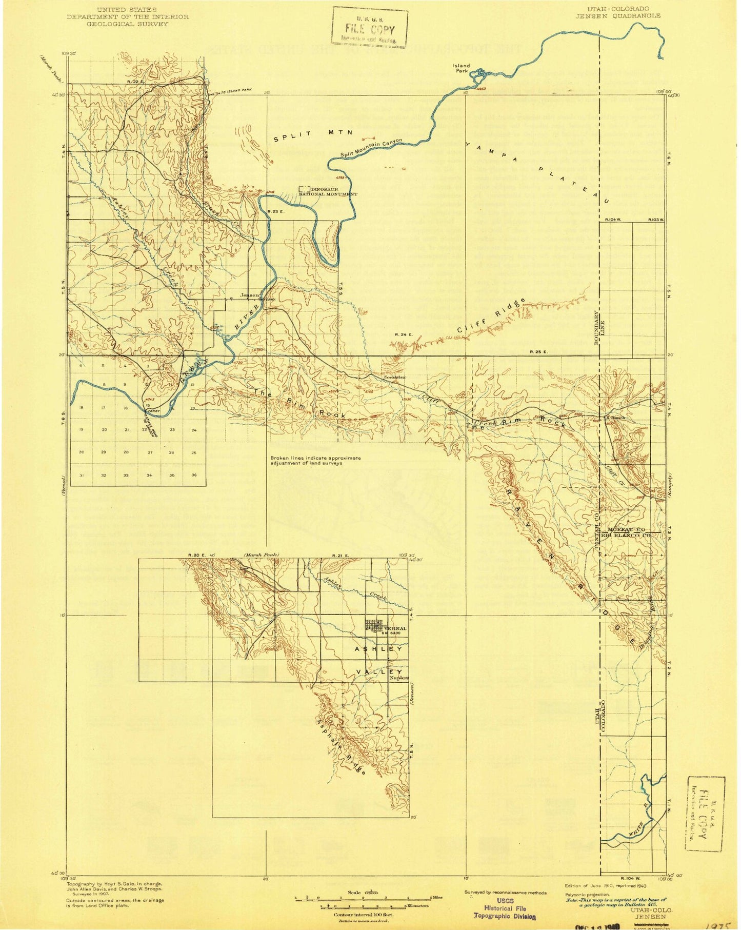
Historic 1910 Jensen Utah 30'x30' Topo Map
Couldn't load pickup availability
Historical USGS topographic map of Jensenin the states of Utah, Colorado. Scale: 1:125000. Print size: 17" x 24"
This map was published in 1910 and is in the following counties: Moffat, Rio Blanco, Uintah.
The map contains contour lines, roads, rivers, towns, streams, and lakes. Printed on high-quality waterproof paper with UV fade-resistant inks.
Contains the following named places: Miners Draw, Trail Creek, K Creek, Sand Spring Wash, Raven Ridge, Gilsonite Draw, Stuntz Ridge, Snake John Reef, Coyote Basin, Ashley Valley, Baser Wash, Beach Draw, Bean Draw, Bear Hollow, Birch Creek, Blind Draw, Bonanza, Bourdette Draw, Brush Creek, Bullwinkle Reservoir, Burns Bench Reservoir, Cheney Ranch, Chapita Wells Gas Field, Clay Basin, Cliff Creek, Cliff Ridge, Cottonwood Wash, Cow Wash, Cow Wash Reservoir, Cowboy Canyon, Coyote Basin Oil Field, Coyote Wash, Cub Creek, Daniels Canyon, Daniels Ranch, Daniels Ranch, Daniels Trail, Deadman Bench, Deadman Bench Divide, Devils Playground, Dinosaur Quarry, Docs Valley, Douglas Chew Cabin, East White River Gas Field, First Gap, Glen Bench, Hacking Reservoir, Hatch Reservoir, Hog Canyon, Horseshoe Bend Oil and Gas Field, Inglesby Rapids, Iron Springs Wash Pool Creek, Jensen, Jensen Wash, Kane Hollow, Kennedy Wash, Left Fork Walker Hollow, Little Bonanza, Little Dicks Bottom, Little Rainbow Park, Mantle Gulch, Mitten Canyon, Moonshine Draw, Moonshine Rapids, Morris Ranch, Naples, Orchid Draw, Pole Line Wash, Powder Springs Gas Field, Powder Springs Wash, Rasmussen Hollow, Red Wash, Red Wash, Red Wash, Red Wash Oil and Gas Field, Right Fork Walker Hollow, Ruple Point, Ruple Ridge, S O B Rapids, Sage Bench, Sand Ridge, Sand Wash, Schoolboy Rapids, Ship Rock, Siddoways Reservoir, Snake John Reef, Snake John Wash, Snow Cabin, Snyder Seeps, South Fork Cub Creek, Split Mountain, Split Mountain Canyon, Split Mountain Gorge Campground, Spring Hollow, Squaw Ridge, Stewart Lake, Stewart Lake Waterfowl Management Area, Stuntz Draw, Sunshine Bench, Susie Ridge, The Rim Rock, The V, Vivas Cake Hill, Walker Hollow, Walker Hollow Oil and Gas Field, Walsh Knolls, White River Oil and Gas Field, Wilkins Cabin, Wonsits-Wonsits Valley Oil Field, Wooley Reservoir, Herman-Sadlier Reservoir, Herman-Sadlier Dam, Blue Mountain Indian Writings, Bonanza RV and Mobile Home Campground, Dinosaur National Monument, Doc Valley Overlook, Escalante Trail Historical Marker, Green River Campground, Green River Ranger Station, Iron Springs Bench Overlook, Island Park Overlook, Point of Pines Recreation Site, Rainbow Park Campground, Red Rock Nature Trail, Split Mountain Overlook, Ashley Creek, Steinaker Draw, Blue Mountain Plateau, Yampa Plateau, Vernal Golf Course, Vernal Substation, Fantasy Canyon, City of Naples, Placer Point, Dudley Pond, Harland Cabin, Stuntz Reservoir, Miners Draw, Chew Ranch, Dripping Rock Creek, K Ranch, Jensen Cabin, Trail Creek, K Creek, Sand Spring Wash, Sand Draw, Bull Canyon, Buckwater Draw, Richardson Draw, Middle Creek, Mormon Gap, Raven Ridge, Dinosaur, Gilsonite Draw, Cottonwood Creek, Stuntz Ridge, Snake John Reef, Coyote Basin, Cliff Creek, Dinosaur National Monument, Yampa Plateau, Rich Mine, Iron Bridge Mine, Town of Dinosaur