MyTopo
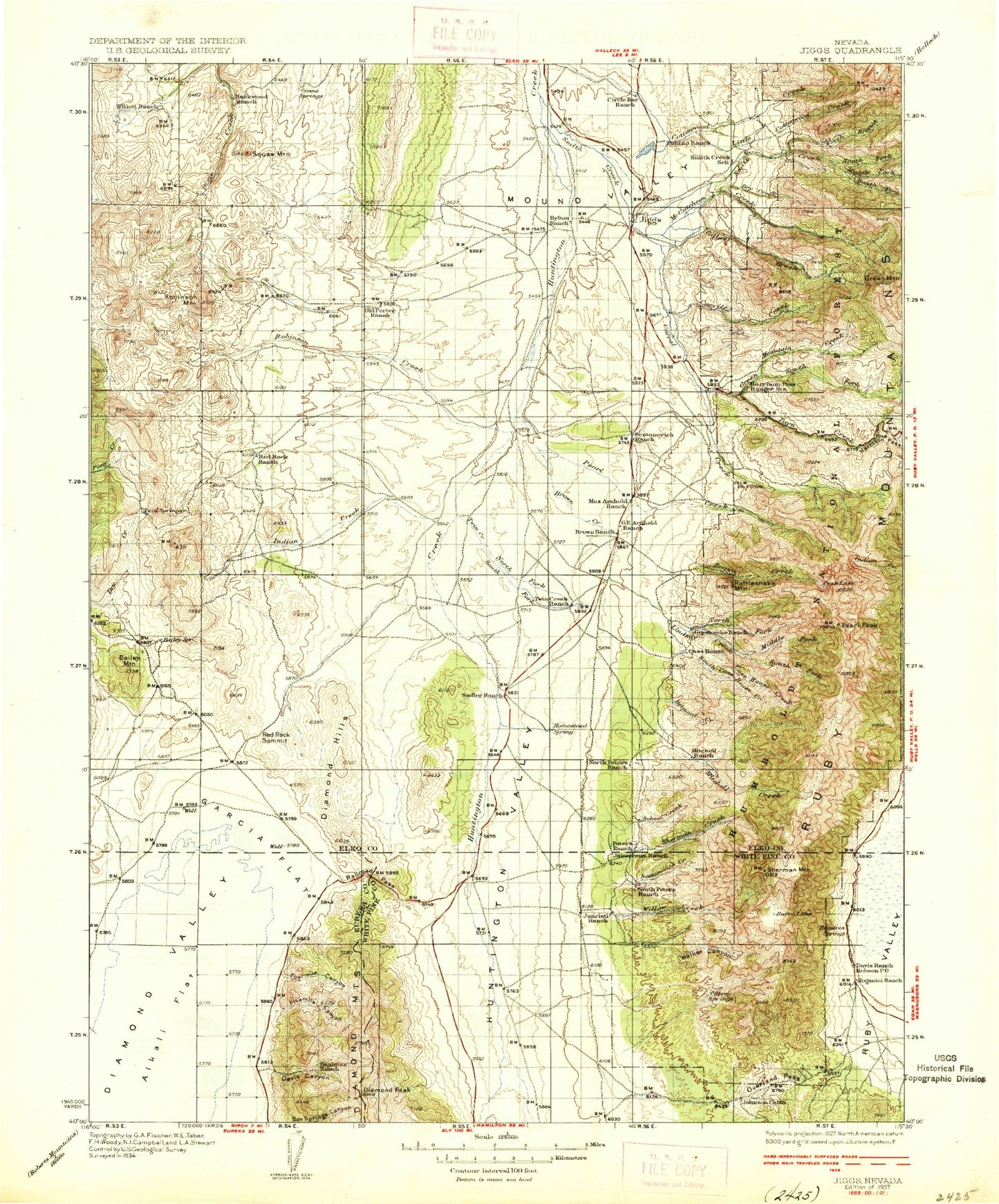
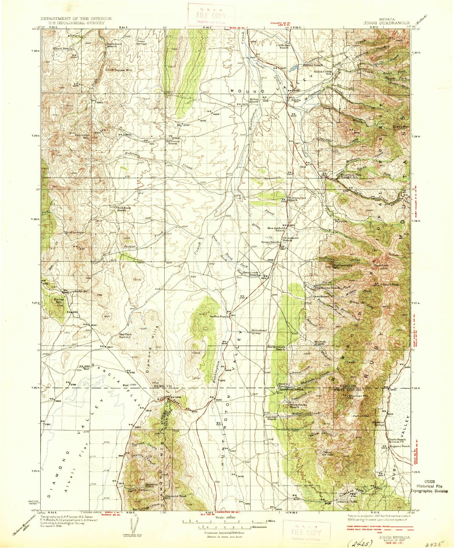
Historic 1937 Jiggs Nevada 30'x30' Topo Map
Couldn't load pickup availability
Historical USGS topographic map of Jiggsin the states of Nevada, Idaho, Oregon. Scale: 1:125000. Print size: 17" x 24"
This map was published in 1937 and is in the following counties: Elko, Eureka, White Pine.
The map contains contour lines, roads, rivers, towns, streams, and lakes. Printed on high-quality waterproof paper with UV fade-resistant inks.
Contains the following named places: Bailey Mountain, Barnes Ranch, Brown Ranch, Cedar Ridge, Cissillini Canyon, Davis Canyon, Diamond Peak, Elliott High Ranch, Frost Creek, Garcia Flat, Hackwood Ranch, Indian Creek, Mitchell Ranch, Mound Valley, North Fork Twin Creek, Old Porter Ranch, Red Rock Ranch, Robinson Creek, Robinson Mountain, Sadler Basin, Squaw Mountain, Twin Creek, Zunino Ranch, Black Mountain, Circle L Ranch, Fivemile Canyon, Fourmile Canyon, Hansel Ranch, Sestanovich Ranch, Diamond Hills, Jiggs, Red Rock Summit, Railroad Pass, Frost Canyon, Mineral Soap Mine, South Fork Robinson Creek, Hansel Windmill, Zunino Ranch, South Branch Cottonwood Creek, Cottonwood Draw, Concord Mine, Baalman Ranch, G E Arnhold Ranch, Max Arnhold Ranch, Millers, North Fork Indian Creek, Diamond Mine, Mulligan Mine, Garcia Mine, Little Porter Creek, Chase Mining District, Diamond Marsh Mining District, Corwin, De Witt Mine, Uncle Sam Mine, Cave Creek Mining District, Carville Basin, Dutchmans Station, Zunino Reservoir, Achurra Ranch, Bellview Mine, Belmont Creek, Big Wash, Brown Creek, Burro Lake, Carville Creek, Cass House Creek, Cherry Spring Canyon, Conners Creek, Corral Creek, Corta Ranch, County Line Pond, Dry Creek, Fort Ruby Ranch, Gennette Creek, Gilbert Creek, Goyeneche Ranch, Green Mountain, Green Mountain Creek, Harrison Pass, Harrison Pass Guard Station, Huntington Valley, Jaimerena Ranch, Johnson Cabin, Juaristi Ranch, Lindsay Creek, Little Cottonwood Creek, Lost Lake, McCutcheon Creek, Merkley Ranch, Middle Fork Lindsay Creek, Middle Fork Smith Creek, Mitchell Creek, Mitchell Ranch, North Fork Lindsay Creek, North Fork Smith Creek, Overland Pass, Pearl Creek, Pearl Lake, Pearl Peak, Peters Ranch, Rattlesnake Mountain, Riordan Ranch, Rocky Canyon, Sadler Ranch, School Creek, Sestanovich Creek, Shanty Town, Sherman Creek, Sherman Mountain, Smith Creek, Smith Creek Ranch, South Cass House Creek, South Fork Green Mountain Creek, South Fork Lindsay Creek, South Fork Smith Creek, South Fork Twin Creek, Toyn Creek, Twin Creek Ranch, Walker Canyon, Water Canyon, Willow Creek, Young Ranch, Zaga Ranch, Banana Pond, Brush Pile Pond, Cass House Peak, Smith Creek Trail, Minola Administrative Site, Pearl Creek Camp, O'Connells Ditch, Suttles Ditch, Davis Ranch, North Peters Ranch, South Peters Ranch, Wright Ranch, Dry Creek, Humboldt National Forest, Zunino Reservoir Dam, Humboldt National Forest, Humboldt National Forest