MyTopo
Historic 1891 Jonesville Kentucky 30'x30' Topo Map
Couldn't load pickup availability
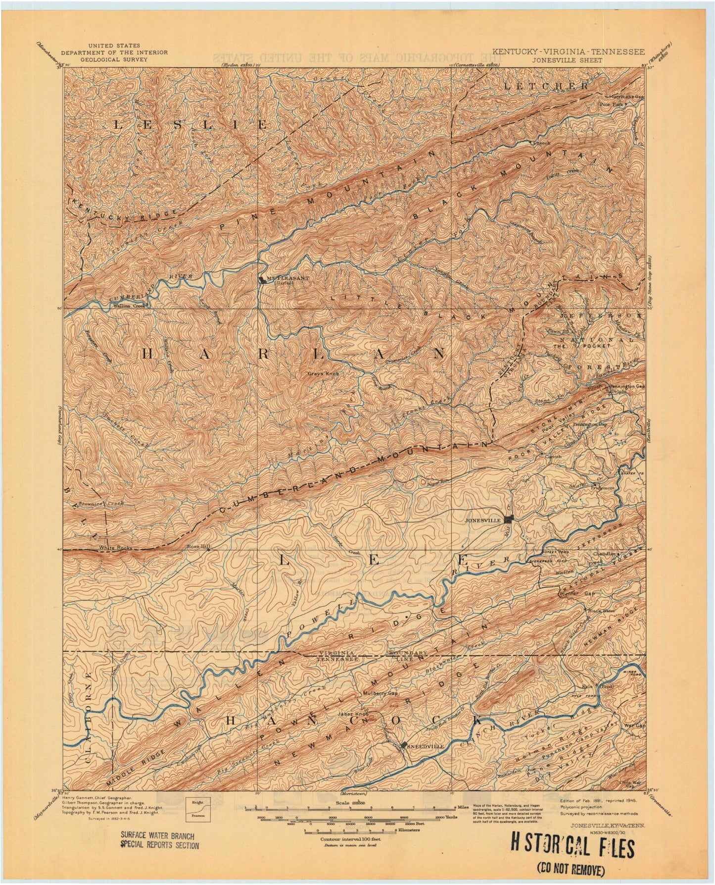
Historical USGS topographic map of Jonesville in the state of Kentucky. Scale: 1:125000. Print size: 18" x 24"
This map was published in 1891 and is in the following counties: Bell, Claiborne, Hancock, Harlan, Hawkins, Lee, Leslie, Letcher, Perry.
The map contains contour lines, roads, rivers, towns, streams, and lakes. Printed on high-quality waterproof paper with UV fade-resistant inks.
Contains the following named places: Abner Branch, Adams Branch, Ages, Alva, Bailes Meadows, Baker Branch, Banner Fork, Bardo, Barn Branch, Baxter, Bear Branch, Beartree Branch, Beartree Gap, Bee Branch, Bee Branch, Ben Saylor Branch, Berts Branch, Big Branch, Big Branch, Big Branch, Big Branch, Bills Creek, Black Mountain, Black Mountain Gap, Blackjoe, Blanton Branch, Board Branch, Bob Day Branch, Bob Lowe Knob, Bobs Creek, Bobs Creek, Bradford Branch, Bridge Branch, Brierfield Gap, Britton Creek, Britton Gap, Brock Branch, Brock Branch, Brookside, Bulldog Hollow, Burgoyne Branch, Butterfly Knob, Camp Branch, Carr Branch, Catron Creek, Catron Gap, Catron Spur, Cawood, Cawood Branch, Cedar Hollow, Chestnut Branch, Chevrolet, Chunklick Branch, Chunklick Spur, Cliff Branch, Cloud Branch, Cloud Branch, Clovertown, Coldiron, Coldiron Branch, Cox Branch, Coxton, Crane Creek, Cranks, Cranks Creek, Cranks Gap, Cranks Ridge, Crawford Branch, Crummies, Crummies Creek, Cutshin Hollow, Cy Branch, Daniel Branch, Darkmont, Dave Smith Branch, Daves Branch, Days Branch, Dick Branch, Dizney, Double Spur, Drakes Branch, Draper, Dressen, Elcomb, Elisha Howard Branch, Enoch Branch, Evarts, Ewing Creek, Ewing Spur, Falling Water Gap, Farmers Branch, Farmers Branch, Farmers Mill, Fisher Hollow, Flat Branch, Foresters Creek, Foresters Spur, Fox Knob, Fresh Meadows, Gabes Branch, Gap Hollow, Ginseng Creek, Golden Ash, Grant Branch, Grays Branch, Grays Knob, Grays Knob, Grays Ridge, Green Branch, Gross Knob, Halls Branch, Happy Top, Harlan, Harlan Gas, Harris Branch, Harris Gap, Hensley Branch, High Fork Branch, Hobbs Fork, Howard Hollow, Ikes Branch, Indian Grave Gap, Insull, Irvin Branch, Jackson Mill Creek, Jerry Branch, Jesse Spur, Jesses Creek, Jones Branch, Jones Branch, Jones Creek, Kentenia, Kenvir, Kildav, Kitts, Kitts Creek, Kitts Knob, Laurel Branch, Laurel Branch, Laurel Branch, Laurel Branch, Laurel Branch, Laurel Branch, Layman, Lee Ann Branch, Lee Branch, Left Fork Cranks Creek, Left Fork Martins Fork Cumberland River, Left Fork Mill Creek, Left Fork Turtle Creek, Lenarue, Lick Branch, Lick Branch, Lick Branch, Liggett, Little Black Mountain, Little Creek, Little Creek, Little Creek, Little Grays Branch, Little Laurel Branch, Little Spur, Littlefield Branch, Lone Spur, Long Branch, Longton, Lowe Branch, Lower Double Branch, Lower Halls Branch, Lower Joe Fork, Lower Laurel Branch, Loyall, Mapple Hollow, Martins Fork Cumberland River, Mary Alice, Mary Helen, McLin Notch, Meadow Branch, Meadow Creek, Middle Fork Cranks Creek, Middleton Branch, Middleton Gap, Mile Branch, Mill Branch, Mill Creek, Mill Creek, Mill Creek, Mill Spur, Molus, Moore Branch, Myer Branch, Napier Branch, Nims Branch, Nolan Branch, Notch Rock, Old Field Branch, Old House Branch, Pansy, Path Fork, Pathfork, Pearl Branch, Pearl Saylor Branch, Penny Branch, Plats Fork, Poplar Lick Branch, Potato Hill Ridge, Potato Knob, Pounding Mill Branch, Pounding Mill Branch, Puckett Ridge, Raccoon Branch, Redbud, Reds Creek, Reids Branch, Rex, Reynolds Mountain, Right Fork Cranks Creek, Right Fork Enoch Branch, Right Fork Mill Creek, Right Fork Turtle Creek, Rio Vista, Road Branch, Rob Blanton Branch, Rock Branch, Rockhouse Branch, Rockhouse Branch, Rockhouse Creek, Rockhouse Gap, Rocky Branch, Rough Branch, Sally Williams Branch, Salt Trace Gap, Saylor Branch, Saylor Creek, Schoolhouse Branch, Second Branch