MyTopo
Historic 1886 Junction City Kansas 30'x30' Topo Map
Couldn't load pickup availability
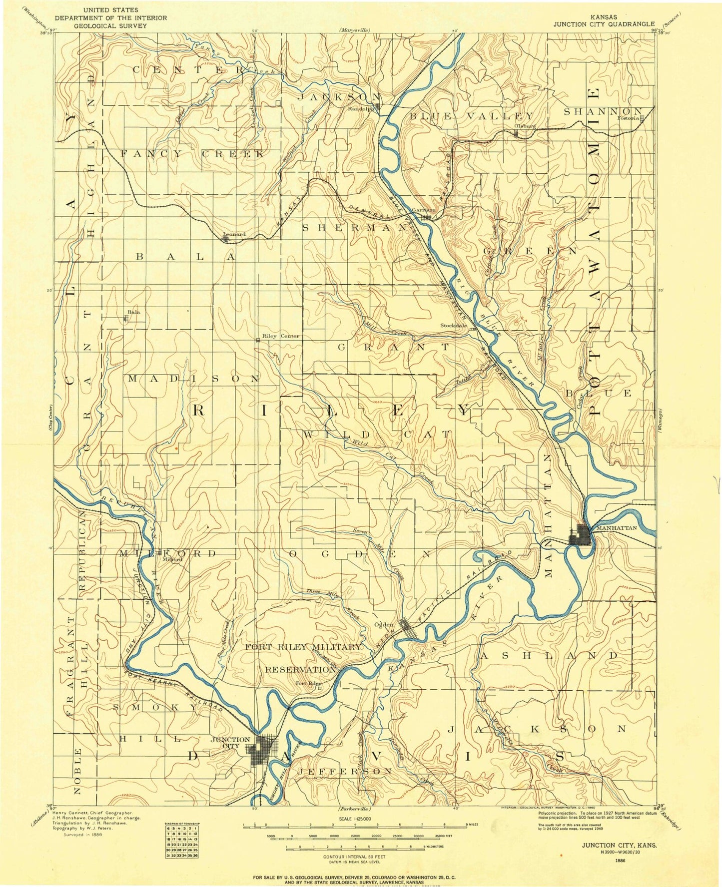
Historical USGS topographic map of Junction City in the state of Kansas. Scale: 1:125000. Print size: 17" x 24"
This map was published in 1886 and is in the following counties: Clay, Dickinson, Geary, Pottawatomie, Riley, Wabaunsee.
The map contains contour lines, roads, rivers, towns, streams, and lakes. Printed on high-quality waterproof paper with UV fade-resistant inks.
Contains the following named places: Tuttle Creek Lake, North Fork Fancy Creek, Township of Center, North Otter Creek, School Branch, Township of Jackson, Swede Creek, Township of Blue Valley, West Branch Mall Creek, May Day, West Fancy Creek, Fancy Creek, Otter Creek, Township of Fancy Creek, Township of Bala, Crooked Creek, Walnut Creek, Randolph, Township of Sherman, Baldwin Creek, Baldwin Creek Recreation Area, Fancy Creek State Park, Randolph State Park, Dry Creek, Booth Creek, Township of Green, Bucksnort Creek, Carnahan Creek, Fostoria, McIntire Creek, Township of Shannon, Milford Lake, Township of Grant, Timber Creek, Bala, Dry Creek, Madison Creek, Township of Madison, Leonardville, Mill Creek, Wildcat Creek, Riley, Silver Creek, Little Arkansas Creek, Township of Grant, Township of Wildcat, Carnahan Creek Recreation Area, Kitten Creek, Tuttle Creek, Township of Blue, Township of Manhattan, Garrison Recreation Area, Stockdale Recreation Area, Spillway State Park, Cedar Creek, Tuttle Creek Dam, Quimby Creek, Township of Milford, Milford Station, Milford, Farnum Creek, School Creek, Rush Creek, Wind Creek, Sevenmile Creek, Honey Creek, Threemile Creek, Township of Ogden, Washington Marlatt Memorial Park, Keats, Little Kitten Creek, Dry Branch, Eureka Valley, Eureka Lake, Camp Eureka, Rebekah IOOF Home, Kansas State University Agronomy Ashland Bottoms Farm, Kansas State Horticulture Farm, Township of Ashland, Ashland Bottoms, Phiel Creek, Rocky Ford, Elbo Creek, Memorial Stadium, Fairman Lake, Longview Hill, Rock Hill, Sunset Park, Manhattan, Finney State Fishing Lake and Wildlife Area, Bluemont Hill, Riverside Park, Griffith Ball Park, Sand Lake, Battery Park, Fairmont, Fremont Point, Prospect Hill, Stagg Hill, Moehlman Bottoms, Hunters Island, Curtis Creek, Alida, Fourmile Creek, Dixon Creek, Breakneck Canyon, Arnold Divide, Harvey Hill, Randolph Hill, Morris Hill, Four Way Divide, Long Draw, Pumphouse Canyon, Cameron Springs Lake, Carpenter Hill, Deep Canyon, Saddle Back, Taylor Point, Wolf Canyon, Caisson Hill, Coyote Canyon, Williston Point, Sheridan Point, Forsyth Creek, Wild Glen, Artillery Hill, Pawnee Flats, Pawnee Point, Backstop Ridge, Governor Harvey Canyon, Republican Point, Republican Flats, Price Ravine, Sherman Heights, Grant Ridge, Macomb Hill, The Island, Ogden Hill, Rock Springs Canyon, Machine Gun Ridge, Magazine Canyon, Onemile Creek, Whiskey Lake, Junction City, Coronado Park, Township of Smoky Hill, Grand View Hill, Franks Creek, Franks Hill, Idle Hour Lake, Junction City Reservoir, Campbell Hill, Rodney Hill, Packers Hill, Sumner Hill, Ogden, Packers Camp, Funston Monument, McDowell Creek, Pressee Branch, West McDowell Creek, Swede Creek, Briggs Branch, East McDowell Creek, Deadman Creek, Township of Jefferson, Clarks Creek, Poole Branch, Horne Branch, Township of Jackson, Township of Wingfield, Humboldt Creek, Thierer Branch, MacArthur Branch, Pottawatomie State Fishing Lake Number Two, Tuttle Creek Wildlife Area, Northerns Airport, Tuttle Creek State Park, Breakneck Dam, Breakneck Lake, Camp Moon Lake, Camp Moon Lake Dam, Rimrock Dam, Jewell County Lake, Milford Dam, Milford State Park, South Branch, North Branch, Prairie National Park, North Branch Kings Creek, Kings Creek, South Branch Kings Creek, West Loop Shopping Center, Village Plaza, Boulevard Bend Shopping Center, Aggieville Shopping Center, West Side Shopping Center, Eureka Valley, Clayview Public Use Area, Timber Creek Public Use Area, Cleary Park, Curtis Creek Public Use Area, Farnam Creek Public Use Area, Filby Park, Flag Stop Park, Freedom Park, Rolling Meadows Golf Course, Milford Recreation Area, Mullins Park, Pawnee Park, Rimrock Park, Rolling Hills Public Use Area, School Creek Public Use Area, Sertoma Park, South Park, Wyman Park, Kaw River Access, Ashland, Goodnow Park, Konza Prairie Natural Area, Longs Park, Manhattan Plant Materials Center, Midwest Raceway, Northview Park, Pioneer Park, Rocky Ford State Fishing Area, Warner Memorial Park, Westwood Park, Natalies Creek, Camp Whitside, Lasita, Winkler, Walsburg, Elm Hollow Corner, Eureka Lake, Grandview Plaza