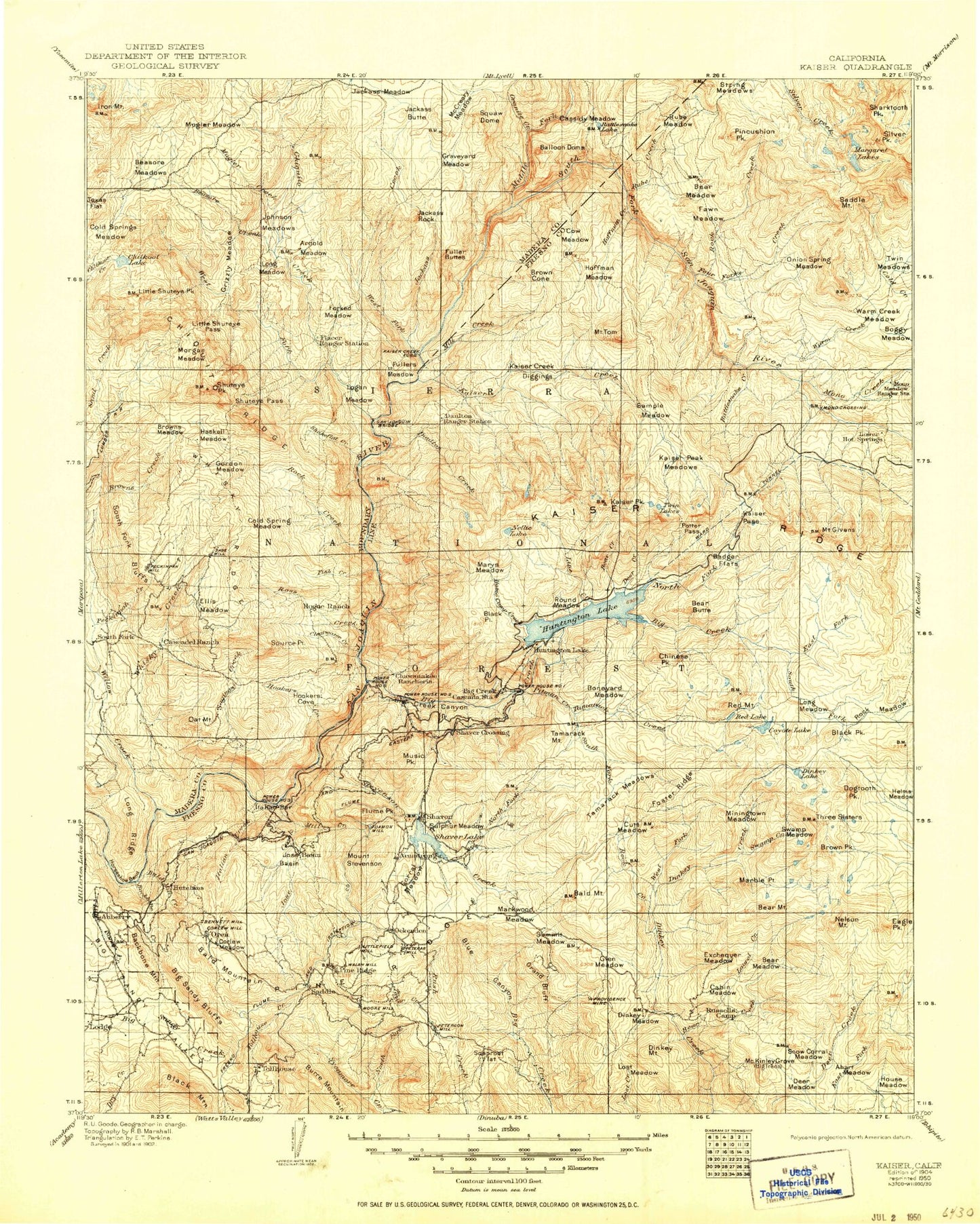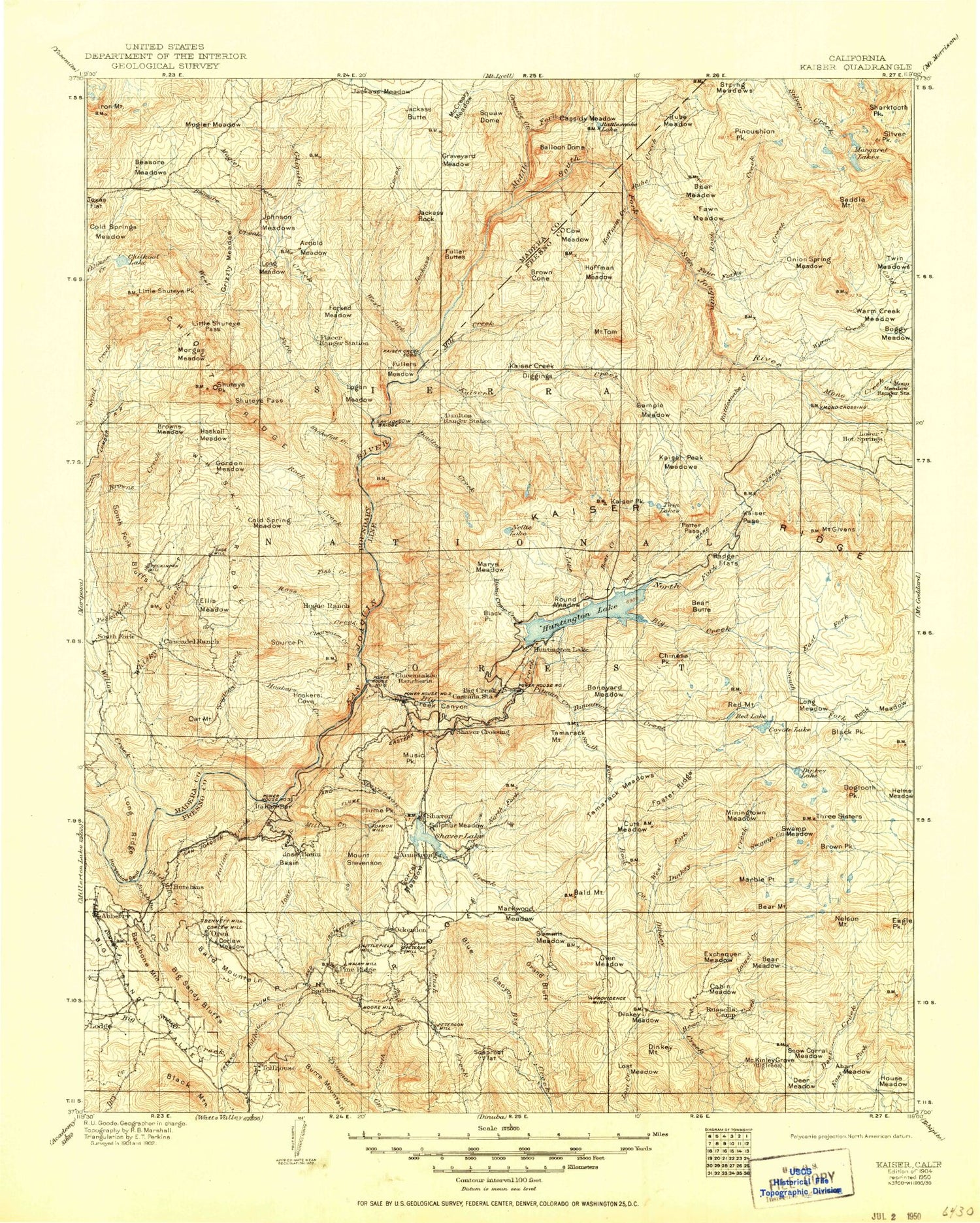
MyTopo
Historic 1904 Kaiser California 30'x30' Topo Map
Couldn't load pickup availability
Historical USGS topographic map of Kaiser in the state of California. Scale: 1:125000. Print size: 17" x 24"
This map was published in 1904 and is in the following counties: Fresno, Madera.
The map contains contour lines, roads, rivers, towns, streams, and lakes. Printed on high-quality waterproof paper with UV fade-resistant inks.
Contains the following named places: Arch Rock, Arnold Meadow, Baby Lake, Bald Mountain, Bare Island Lake, Bathtub Lake, Beasore Meadows, Beetlebug Lake, Big Margaret Lake, Buchenau Cabin, Camp Chawanakee, Cockscomb Lakes, Cold Creek, Cold Spring Meadow, Coyote Lake, Fawn Meadow, Fern Lake, Four Forks Creek, Frog Lake, Fuller Buttes, Future Farmers of America Camp, Grizzly Meadow, Hedrick Meadow, Iron Lakes, Iron Mountain, Island Lake, Jackass Rock, Johnson Meadows, Junction Lake, Kates Cow Camp, Little Doris Lake, Little Shuteye Pass, Little Shuteye Peak, Lost Lake, Margaret Lakes, McSwain Mine, Midge Lake, Mono Meadow, Mountain Rest Guard Station, Muglers Meadow, Musick Guard Station, North Fork Sycamore Creek, Old Bretz Mill, Onion Spring Meadow, Pincushion Peak, Pocket Lake, Providence Creek, Rainbow Lake, Reef Lake, Rock Creek Lake, Saddle Mountain, Sand Lake, Scarab Lake, Sharktooth Lake, Shaver Trail, Shorty Lake, Shuteye Pass, Silver Peak, Pine Ridge, Soaproot Flat, Soaproot Saddle, Soda Springs Campground, South Fork Bluffs, Piyau Dome, Mount Stevenson, String Meadows, Summit Creek, Taylor Creek, Tule Meadow, Twin Meadows, Warm Creek Meadow, Cockscomb, Kaiser Peak, Reconnaissance Creek, Reconnaissance Meadows, Camino Falls, Dutch Oven Creek, Whisky Falls, Aspen Creek, Coarsegrass Meadow, Douglas Fir Creek, Horsethief Creek, Jump Off Point, Logan Meadow, Lookout Point, Saddle Creek, Slot Creek, West Fork Daulton Creek, Camp Creek, Hells Half Acre Trail, Jackass Rock Organization Camp, South Fork Trail, French Trail, Jones Store, Topping Cow Camp, Camp Five Campground, Whites Cabin, China Bar Campground, Mammoth Pool Boat Launch, Mammoth Pool Campground, Mile High Vista Picnic Area, Placer Campground, Placer Guard Station, Beasore Creek, Boggy Meadow, Browns Creek, Browns Meadow, Camino Creek, Chilkoot Lake, Chiquito Ridge, Cold Springs Meadow, Forked Meadow, Globe Rock, Gordon Creek, Gordon Meadow, Beasore Subdivision, Graveyard Meadow, Grizzly Lake, Haskell Meadow, Hells Half Acre, Jackass Butte, Jackass Meadow, Little Jackass Campground, Long Meadow, Long Meadow, Lost Lake Creek, Lower Chiquito Campground, McCreary Meadow, Morgan Meadow, Mugler Creek, Norris Creek, North Fork Sand Creek, Owl Creek, Peckinpah Meadow, Roush Creek, Sand Creek, Shuteye Peak, Jackass Creek, Summit Meadow, Texas Flat, Timber Creek, Whiskers Campground, Sedge Lake, Pineridge, Sierra National Forest, Aspen Meadow, Auberry Guard, Avalanche Lake, Backbone Creek, Backbone Mountain, Badger Flat, Bald Mountain, Balloon Dome, Barnes Mountain, Bear Butte, Bear Meadow, Bear Meadow, Benedict Meadow, Beryl Lake, Big Creek, Big Creek Canyon, Big Sandy Bluff, Bill Lake, Billy Creek, Black Mountain, Black Peak, Black Point, Bobby Lake, Bolsillo Campground, Boneyard Meadow, Bonnie Lake, Brewer Lake, Brown Cone, Bullfrog Lake, Byles Johnson Camp, Camp Sixty One Campground, Camp Sixty One Creek, Camp Sixty One D Campground, Camp Sixty One Lake, Camp Creek, Camp Fresno, Camp Oljato, Campfire Lake, Cascadel Point, Cascadel Ranch, Cassidy Meadows, Castle Peak, Chawanakee Flats, Chinese Peak, Chinquapin Creek, Clearwater Creek, Cliff Lake, College Lake, Coon Creek, Corbett Lake, Corrine Lake, Cow Creek, Cow Meadow, Coyote Lake, Crater Lake, Crater Lake Meadow, Cunningham Lake, Cutts Meadow, Daulton Creek, Daulton Station, Deer Creek, Deer Lake, Devils Table, Dinkey Creek Ranger Station, Dinkey Dome, Dinkey Meadow, Dinkey Meadow Creek, Dinkey Mountain, Dogtooth Peak, Doris Lake, Duff Creek, East Fork Big Creek, East Lake, Eastern Brook Lake, Ely Meadow, Ely Mountain, Ershim Lake, Fingerbowl Lake, First Dinkey Lake, Fish Creek, Fish Creek Campground, Flume Peak, Forked Meadow Creek, Foster Ridge, Fuller Meadow, George Lake, Gertrude Creek, Mount Givens, Glen Meadow, Glen Meadow Creek, Gloria Meadow