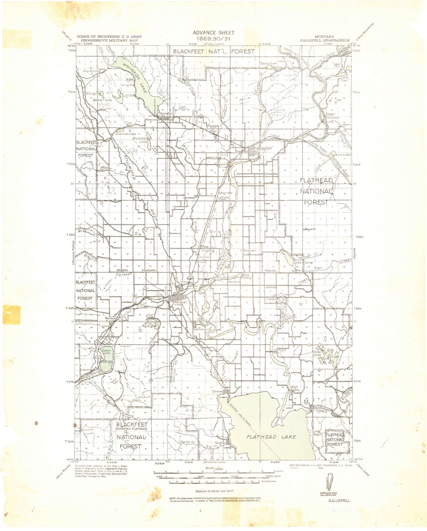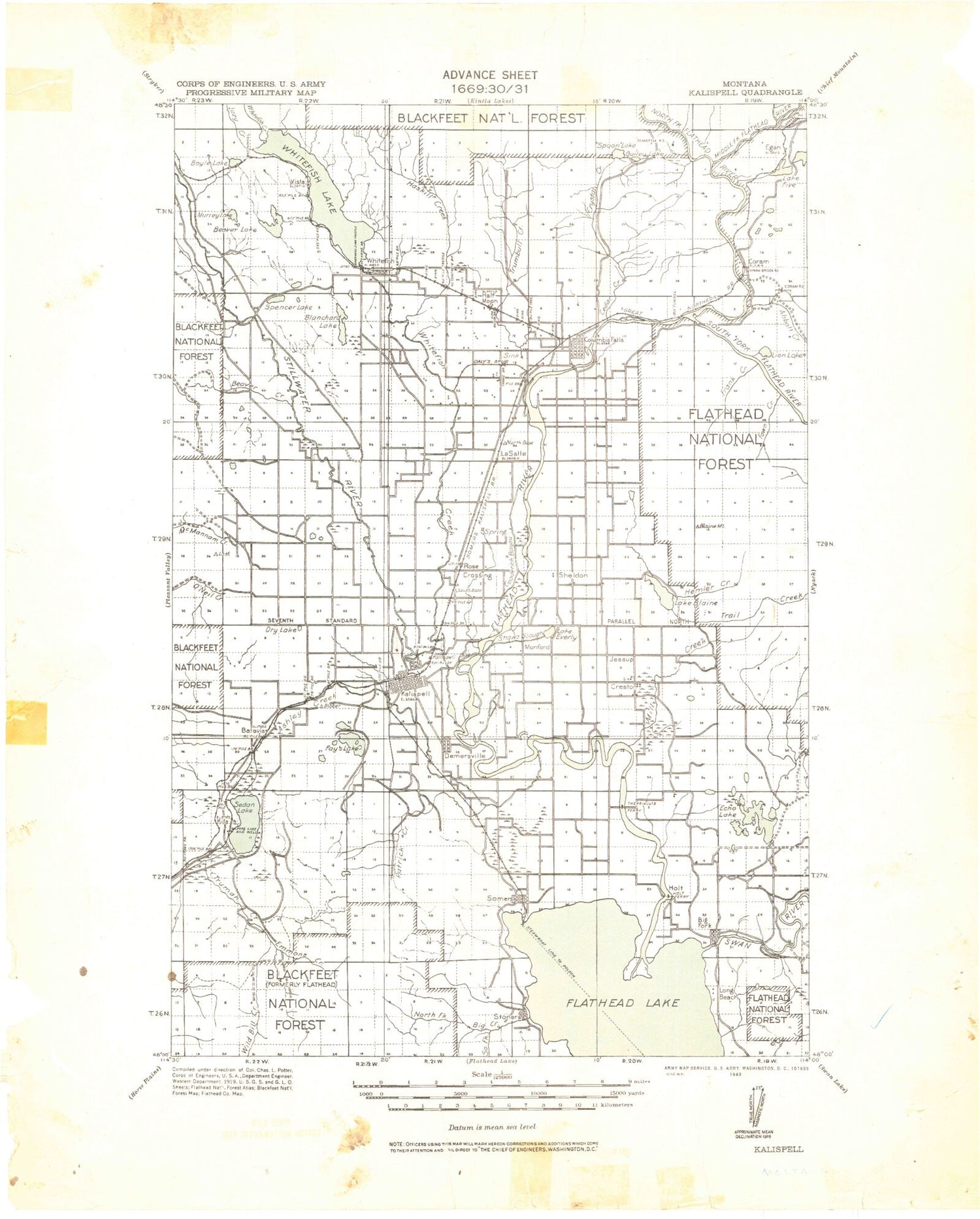
MyTopo
Historic 1943 Kalispell Montana 30'x30' Topo Map
Couldn't load pickup availability
Historical USGS topographic map of Kalispell in the state of Montana. Scale: 1:125000. Print size: 19" x 24"
This map was published in 1943 and is in the following counties: Flathead, Lake.
The map contains contour lines, roads, rivers, towns, streams, and lakes. Printed on high-quality waterproof paper with UV fade-resistant inks.
Contains the following named places: Coram, Lazy Bay, Morning Slough, Wild Horse Mountain, Abbot Creek, Abbot Lake, Alora Creek, Alpha Creek, Alpha Lake, Alpine Trail, Ashley Creek, Ashley Creek Ditch, Aurora Creek, Badrock Canyon, Bailey Lake, Bald Mountain, Bald Rock, Baldy Mountain, Bales Creek, Baney Lake, Basham Lake, Bay Point, Beaver Bay, Beaver Creek, Beaver Creek, Beaver Lake, Beta Creek, Beta Lake, Bierney Creek, Big Fork Dam, Big Fork Ranger Station, Big Lost Creek, Whitefish Mountain Resort, Birch Creek, Blackies Bay, Blacktail Mountain, Blaine Mountain, Lake Blaine, Blanchard Lake, Blue Grass Ridge, Blue Lake, Boorman Creek, Bootjack Lake, Bowser Lake, Boyle Lake, Brown Creek, Brown Creek, Brown Gulch, Brush Bay, Brush Creek, C M Quarter Circle Ranch, Cabin Lake, Carney Creek, Carver Bay, Cedar Creek, Cedar Lake, Church Slough, Circle Lake, Cliff Creek, Cliff Lake, Columbia Mountain, Columbia Mountain Trail, Conrad Point, Conrad Ranch, Coon Hollow, Cove Creek, Cow Creek, Cramer Creek, Cree Lake, Creston, Crystal Creek, Danielson Ranch, Deer Island, Dern Draw, Devils Elbow, Dog Bay, Dollar Lake, Doris Creek Trail, Doris Mountain, Doris Ridge, Double Lake, Dry Lake, Eagle Creek, Eagle Mountain, Eagle Point, East Bass Lake, Echo Creek, Echo Lake, Egan Slough, Emmons Creek, Estes Lake, Evergreen, Fawn Creek, Fawn Lake, Fennon Slough, Lake Five, Flathead River Ranger Station, Foys Bend, Frank Creek, Gaines Point, Garlick Lake, Garnier Creek, Gilbert Lake, Glacier Bible Camp, Glazier Ranch, Gooderich Bayou, Grayling Lake Number One, Grayling Lake Number Two, Griffin Park, Half Moon Slough, Halfmoon Lake, Handkerchief Creek, Hanson Lake, Hanson-Doyle Lake, Harbin Lake, Hash Mountain, Haskill Basin, Haskill Creek, Hatch Meadow, Hawks Lake, Haywire Gulch, Hell Roaring Basin, Hell Roaring Creek, Hell Roaring Point, Hemler Creek, Hoffman Draw, Houston Point, Hungry Horse, Inez Point, Jackson Draw, Jessup Mill Pond, Johnson Lake, Kalispell, Kalispell Bay, Kaufmans Lake, Keller Ranch, Kid Lake, Kienas Ranch, Kila, Kohler Lake, Krause Creek, Lakeside, Lamoose Lake, Lawrence Park, Lazy Creek, Lion Hill, Lion Lake, Lion Mountain, Lion Mountain, Little Beaver Lake, Little Bootjack Lake, Lone Pine State Park, Lone Pine State Preserve, Lore Lake, Lost Creek, Lost Lake, Mackinaw Bay, Mackinaw Point, Martin City, McGilvray Lake, McMannamy Draw, McWenneger Slough, Meadow Lane Ranch, Micho Mine, Micho Trail, Middle Fork Flathead River, Midway Grange, Mill Creek, Monks Bay, Motichka Creek, Mount Creek, Mud Creek, Mud Lake, Murray Lake, Noisy Creek, Norden Cabin, North Fork Flathead River, Northwestern Lake, Olive Lake, Olson Creek, Orchard Point, Otila Basin, Patrick Creek, Peaceful Bay, Pete Ridge, Peters Creek, Peters Ridge, Peterson Lake, Pilot Knob, Pleasant Island, Plummers Lake, Point of Pines, Point Caroline, Pratt Lake, Rainbow Lake, Rhodes, Rhodes Draw, Rose Creek, Rose Crossing, Sampson Lake, Sand Creek, Sawdust Lake, Schultz Ranch, Seneca Creek, Shaws Slough, Sheepherder Hill, Shelter Valley Ranch, Silver Buckle Ranch, Silver Run Creek, Skyles Lake, Sloan Ranch, Smith Creek, Smith Lake, Smith Lake, Smith Valley, Somers, South Fork Abbot Creek, South Fork Canyon Creek, South Fork Flathead River, South Fork Hemler Creek, Spencer Lake, Spill Lake, Spoon Lake, Spring Creek, Spring Creek, Stillwater Grange, Stillwater River, Stoner Creek, Swan River, Swan River, Swift Creek, Swimming Lake, Talmadge Lake, Tamarack Lake, Teakettle Mountain, The Island