MyTopo
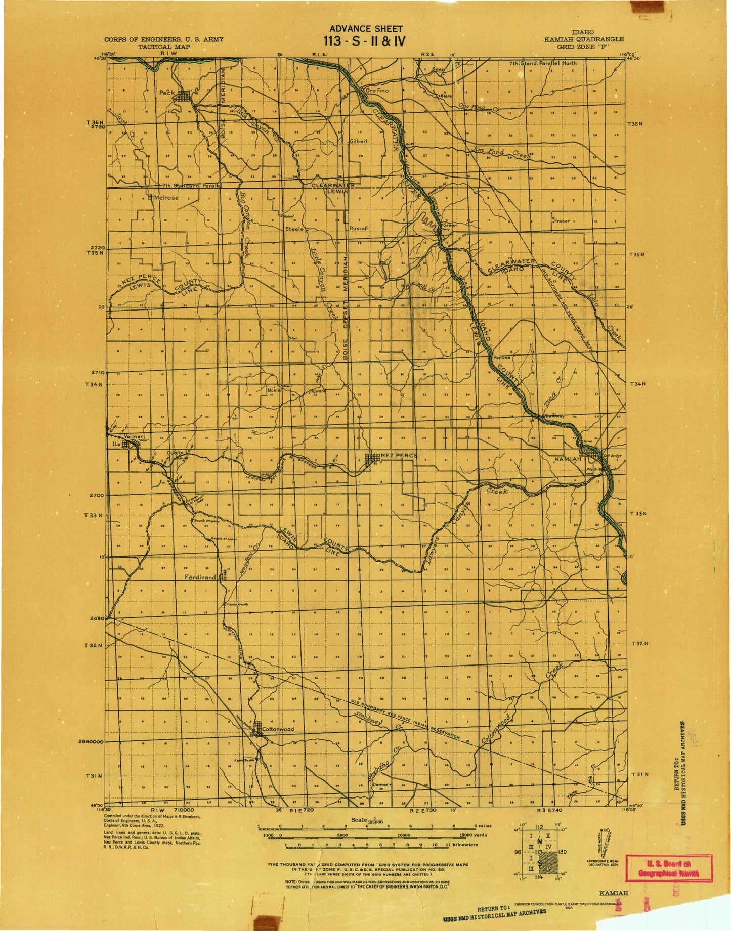
Historic 1924 Kamiah Idaho 30'x30' Topo Map
Couldn't load pickup availability
Historical USGS topographic map of Kamiah in the state of Idaho. Scale: 1:125000. Print size: 18" x 24"
This map was published in 1924 and is in the following counties: Clearwater, Idaho, Lewis, Nez Perce.
The map contains contour lines, roads, rivers, towns, streams, and lakes. Printed on high-quality waterproof paper with UV fade-resistant inks.
Contains the following named places: Angel Ridge, Big Butte, Cook Creek, Cottonwood, Cottonwood Butte, Cottonwood Job Corps Center, Greencreek, Harpers Bend, Holes Creek, Icicle Flat, Keuterville, Lawyer Creek, Long Hollow Creek, Meadow Creek, Mitchell Creek, Red Rock Creek, Shebang Creek, Sixmile Canyon, Stockney Creek, Twin Buttes, Willow Creek, Dryden, Fletcher, Melrose, Big Canyon Creek, Big Creek, Cedar Creek, Central Ridge, Church Canyon, Cooper Creek, Deer Creek, Doty Draw, Effie Creek, Fivemile Creek, Fraser Grange, Fraser Park, Incendiary Creek, Jameson Draw, Jim Ford Creek, Lawyer Creek, Lewis-Clark Canoe Camp State Park, Little Canyon Creek, Long Haul Creek, Meadow Creek, Nichols Canyon, Nikesa Creek, North Fork Clearwater River, Posthole Canyon, Riverside, Rudo Creek, Russell, Schmidt Creek, Sevenmile Creek, Sixmile Creek, South Fork Cottonwood Creek, Suzie Creek, Texas Creek, Thorn Springs Creek, Tom Taha Creek, Whiskey Creek, Woodland, Canyon and Kelly Creek Ranger Station, Long Camp and ASA Smith Mission, Riverfront Park, Heart of the Monster Point of Interest, Pierce Ranger Station, Schmidt Mill, Lewis County, East Kamiah, Ferdinand, Fraser, Greer, Kamiah, Mohler, Nezperce, Orofino, Red Rock Butte, Harrisburg, Pardee, Pardee Corner, Peck, Peck, Rudo, Snells Island, Tramway, Thompson Dam, Lolo Creek, Howard, Harris Siding, Konkolville, Syron Draw, Six Mile Canyon, Brunning, Blake, Cooper, Christmans, Dublin Siding, Nez Perce Reservation, Vollmer, Craigmont, Orofino Creek, Winona, Peck Access Area, Greer Access Area, Kamiah Holding Ponds, West Fork Woodland Grade Creek, Woodland Grade Creek, East Fork Woodland Grade Creek, Craigmont Division, Kamiah Division, Nez Perce Division, Nez Perce Division, Nezperce Division, City of Kamiah, City of Cottonwood, City of Craigmont, City of Ferdinand, City of Nezperce, City of Orofino, City of Peck