MyTopo
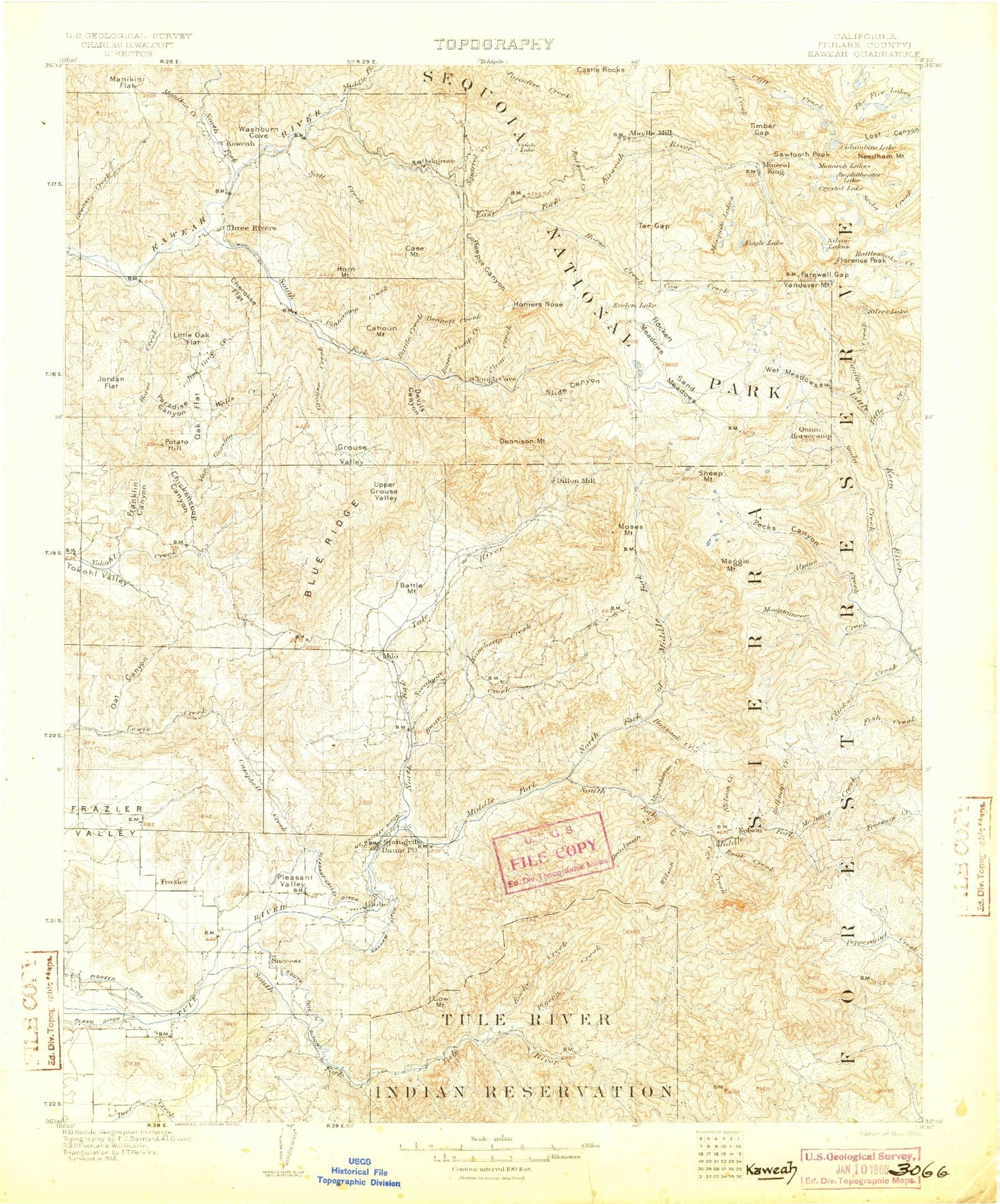
Historic 1904 Kaweah California 30'x30' Topo Map
Couldn't load pickup availability
Historical USGS topographic map of Kaweah in the state of California. Scale: 1:125000. Print size: 17" x 24"
This map was published in 1904 and is in the following counties: Tulare.
The map contains contour lines, roads, rivers, towns, streams, and lakes. Printed on high-quality waterproof paper with UV fade-resistant inks.
Contains the following named places: Alder Creek, Atwell Creek, Atwell Hockett Trail, Atwell Mill Ranger Station, Bartlett Park, Bateman Ridge, Bear Creek, Bear Creek, Black Mountain Grove, Black Mountain Trail, Buckeye Gulch, Cahoon Rock Lookout, Camp Conifer, Camp Whitsett, Campbell-Moreland Ditch, Campground Guard Station, Carver Camp, Cedar Creek, Clover Creek, Crane Meadow, Crawford Camp, Crawford Creek, Deep Canyon, Dome Creek, Dome Rock, Eagle Creek, East Fork Grove, Eden Creek Grove, Evelyn Lake, Freezeout Meadow, Grouse Peak, Hatchet Peak, Hickman Creek, Hockett Meadow Trail, Hockett Ranger Station, Holby Meadow, Homers Nose, Homers Nose Grove, Horse Canyon, Horse Creek, Horse Creek Grove, Hungry Hollow, Ice Creek, Kessing Creek, Kramer Meadow, Last Chance Meadow, Long Canyon, Lumreau Mountain, Middle Creek, Middle Fork Tule River, Mine Hill, Miner Creek, Mount Whitney Ditch, Mule Meadow, Mule Peak, Nobe Young Meadow, North Fork Tule River, Oat Canyon, Onion Meadow, Oriole Grove, Peyrone Camp, Peyrone Grove, Pigeon Creek, Pine Top Mountain, Pioneer Ditch, Quaking Aspen Meadow, Rancheria Creek, Red Hill Grove, Redwood Camp, Redwood Creek, Rocky Hill, Rocky Hills, Rogers Camp, Round Meadow, Sand Hill Ridge, Sentinel Peak, Silver City, Simmons Post Camp, Siphon Canyon, Slapjack Creek, Slate Mountain, Solo Peak, South Bear Creek, South Fork Tule River, Spanish Camp, Springville, Success Dam, Summit Trail, Sycamore Creek, Van Gordon Creek, Ward Canyon, Windy Creek, Windy Gap, Highbridge Creek, Fowler Creek, Deadwood Creek, Corner Creek, Putman Creek, Cahoon Rock, Lumer, Magnolia, Sunland, Worth, Hockett Meadows, Deer Creek, Eden Creek, Paradise Peak, Paradise Ridge, Lake Success, Tar Gap, Atwell Grove, Cahoon Creek, Cahoon Meadow, Castle Rocks, Conifer Ridge, Lake Kaweah, Little Five Lakes, Oriole Lake, Red Hill, Whitman Creek, Sequoia National Forest, Gibbon Creek, Alder Creek, Alder Creek Grove, Alpine Creek, Alpine Meadow, Amphitheater Lake, Ansel Lake, Ash Mountain National Park Headquarters, Backbone Creek, Balch Park, Battle Creek, Battle Mountain, Bear Creek, Belknap Camp Grove, Belknap Creek, Bennett Creek, Big Campbell, Big Five Lakes, Black Rock Pass, Blossom Lakes, Blossom Peak, Blue Canyon, Blue Creek, Blue Ridge, Blue Ridge Lookout, Bond Creek, Boulder Creek, Bullfrog Lakes, Burnt Camp Creek, Burro Creek, Cahoon Mountain, Camp Wishon, Campbell Creek, Case Mountain, Case Mountain Grove, Cedar Creek, Cherokee Flat, Chickencoop Canyon, Cinnamon Creek, Cinnamon Gap, Clicks Creek, Coffee Canyon, Coffee Mill Meadow, Coffeepot Canyon, Columbine Lake, Comb Rocks, Cow Mountain, Cow Mountain Creek, Coy Creek, Coy Flat, Crew Creek, Grunigen Creek, Crystal Creek, Crystal Lake, Cyclamen Lake, Cyclone Meadow, Deadman Creek, Deep Meadow, Dennison Mountain, Dennison Peak, Dennison Ridge, Devils Canyon, Dillonwood Grove, Duncan Canyon, Eagle Creek, Eagle Lake, East Fork Kaweah River, Mount Eisen, Empire Mountain, Farewell Canyon, Farewell Gap, Mount Florence, Franklin Canyon, Franklin Creek, Franklin Lakes, Franklin Pass, Freeman Creek Grove, Frog Lakes, Galena Creek, Garfield Creek, Garfield Grove, Good Hope Mines, Graham Creek, Graham-Osborn Ditch, Greasy Creek, Green Meadow, Grey Meadow, Grouse Creek, Grouse Valley, Hidden Lake, Hockett Lakes, Horn Mountain, Horse Creek, Hossack Creek, Hossack Meadow, Hunter Creek, Jacobsen Meadow, Jacobson Creek, Jenny Creek, Jim Gray Creek, Joaquin Flat, Jordan Flat, Jordan Peak, Junction Meadow, Kramer Creek, Lion Creek, Little Claire Lake, Little Oak Flat, Log Cabin Meadow, Loggy Meadows, Long Branch, Long Meadow, Lookout Point Ranger Station, Maggie Lakes, Maggie Mountain