MyTopo
Historic 1894 Kerrville Texas 30'x30' Topo Map
Couldn't load pickup availability
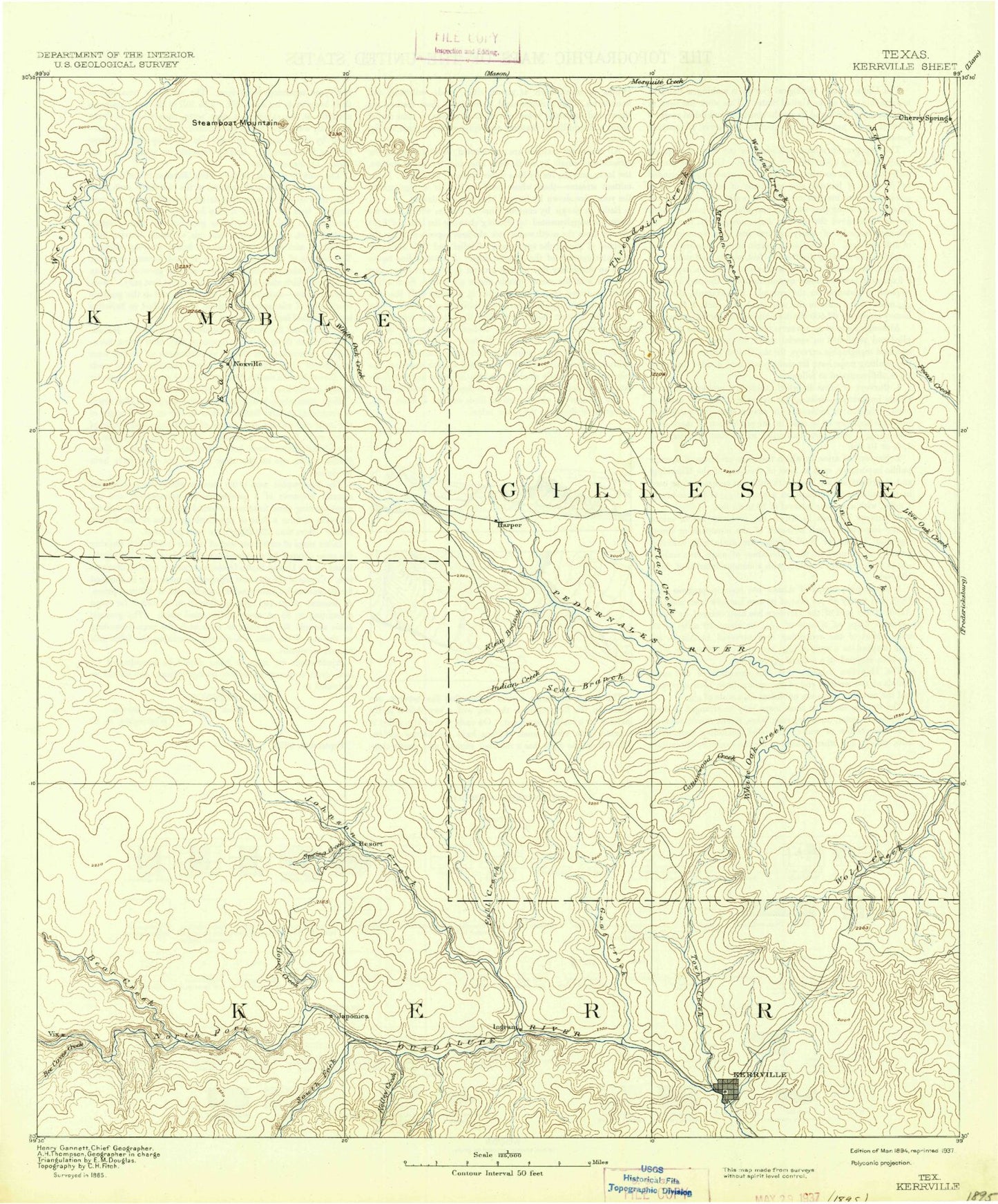
Historical USGS topographic map of Kerrville in the state of Texas. Scale: 1:125000. Print size: 17" x 24"
This map was published in 1894 and is in the following counties: Gillespie, Kerr, Kimble, Mason.
The map contains contour lines, roads, rivers, towns, streams, and lakes. Printed on high-quality waterproof paper with UV fade-resistant inks.
Contains the following named places: AK Bar Ranch, Adobe Creek, Back Pasture Windmill, Banta Branch, Barnett Branch, Bear Creek, Bear Creek, Bear Hollow, Bee Cave Windmill, Bee Caves Creek, Bell Hollow, Bittle Ranch, Brushy Branch, Brushy Branch, Burr Oak Creek, Byas Branch, Camp Arrowhead, Camp LaJunta, Camp Meeting Creek, Camp Mystic, Camp Pearl Wheat, Camp Rio Vista, Camp Scenic, Camp Stewart, Camp Waldemar, Canyon Creek, Carver Park, Centipede Branch, Cherry Creek, Circle D Ranch, Conrad Meadows Ranch, Contrary Creek, Cottonwood Ranch, Cow Head Hollow, Cypress Creek, Delaware Creek, Devils Creek, Dittmar Creek, Domingues Ranch, Dove Windmill, Drill Hollow, Dry Branch, Dry Creek, Dry Section Windmill, Durst Windmill, East Town Creek, East Windmill, East Windmill, Eclipse Windmill, Edmunson Creek, Fall Branch, Fessenden Branch, Field Windmill, Field Windmill, Flag Creek, Four Corners Windmill, George Hollow, Goat Creek, Grays Branch, Haddenbrock Hill, Hains Branch, Henderson Branch, Honey Creek, Honey Creek Ranch, Hunt, Indian Branch, Indian Creek, Indian Creek, Indian Creek Camp, Ingram, Jarman Windmill, Johnson Bottom, Johnson Creek, Kelley Creek, Kerrville, Kerrville State Park, Kits Hollow, Kott Valley, Lange Ravine, Lazy Hills Ranch, Lazy Lane Ranch, Legion, Lions Camp for Crippled Children, Lions Park, Louise Hays Park, MO Ranch, Midway Station, Mitchke Valley, Monroe Hollow, Moore Ranch, Morris Ranch, Mountain Home, Lake New Ingram, New Windmill, Nichols Creek, North Creek, Nott Branch, Lake Old Ingram, Old Noxville, Other Windmill, Ox Hollow, Patio Ranch, Pecan Creek, Pillar Rock, Plot Windmill, Priess Hollow, Quinlan Creek, Rattlesnake Creek, Ravenhead, Richard Park, Ringtail Windmill, Rocky Ford Ranch, Rocky Ridge Ranch, Roundhead, San Antonio Camp, Second Creek, South Fork Guadalupe River, South Windmills, Spanish Oak Creek, Spring Branch, Spring Creek, Spring Creek, Stevens Creek, Stuckens Branch, Tecaboca Camp, Tegener Creek, Telephone Hill Windmill, Telgmann Valley, Third Creek, Tivy Mountain, Town Creek, Trails End Ranch, Trails End Ranch, Triple H Ranch, Triple Tanks Windmill, Trough Spring Creek, Turkey Windmill, Wade Hollow, Wagon Wheel Ranch, Walnut Creek, Walnut Creek, Waltonia, West Dry Branch, West Goat Creek, West Windmill, White Oak Creek, White Oak Creek, Windmill Number Two, Bear Hollow, Bee Cave Creek, Bierschwale Windmill, Bone Hollow, Brockmann Point, Buckeye Point, Burnt Branch, Cedar Branch, Cedar Creek, Cedar Gap, Chimney Hollow, County Line Hill, Dicks Hollow Windmill, Dry Mormon Creek, Falls Prong Windmill, Hartmann Hollow, Hermans Point, Hog Creek, House Hollow, Indian Creek, Indian Point, Lehmann Mountain, Little Windmill, Long Hollow, Mund Hill, Neyland Mine, Nixon Creek, North Trap Windmill, North Windmill, Old Windmill, Onion Creek, Rayner Hollow, Rock House Windmill, Rodgers Trap Windmill, Schoolhouse Hollow, Section Windmill, South Trap Windmill, Steamboat Mountain, Swayback Creek, Swayback Mountain, Tobe Branch, Tom Hollow, Welge Poing, White Bluff, White Oak Creek Reservoir, Wolf Draw, Bur Oak Draw, Bur Oak Windmill, Daisy Windmill, Draw Windmill, Edwards Creek, Elm Creek, Falls Prong, Flores Creek, Fox Hollow, Harper, Hilltop Windmill, Jim Little Draw, Klein Branch, Little Devils River, Maverick Spring Branch, Middle Creek, Mormon Creek, New Windmill, North Fork Guadalupe River, Pecan Spring Branch, Priess Pasture Windmill, Rogers Draw, Rough Hollow, Shin Oak Creek, South Windmill, Spring Hollow, The Falls, Wein Schlucht, White Oak Creek, Mount Wesley, Tivydale, Cherry Spring, Doss, Noxville, Kerr County, Blackburn Dam, Horsman Dam, Ingram Lake Dam, Dam J Lake, Cullum Estate Number 1 Dam, Cullum Lake, Cedar Lake Dam