
MyTopo
Historic 1906 Kirwin Wyoming 30'x30' Topo Map
Couldn't load pickup availability
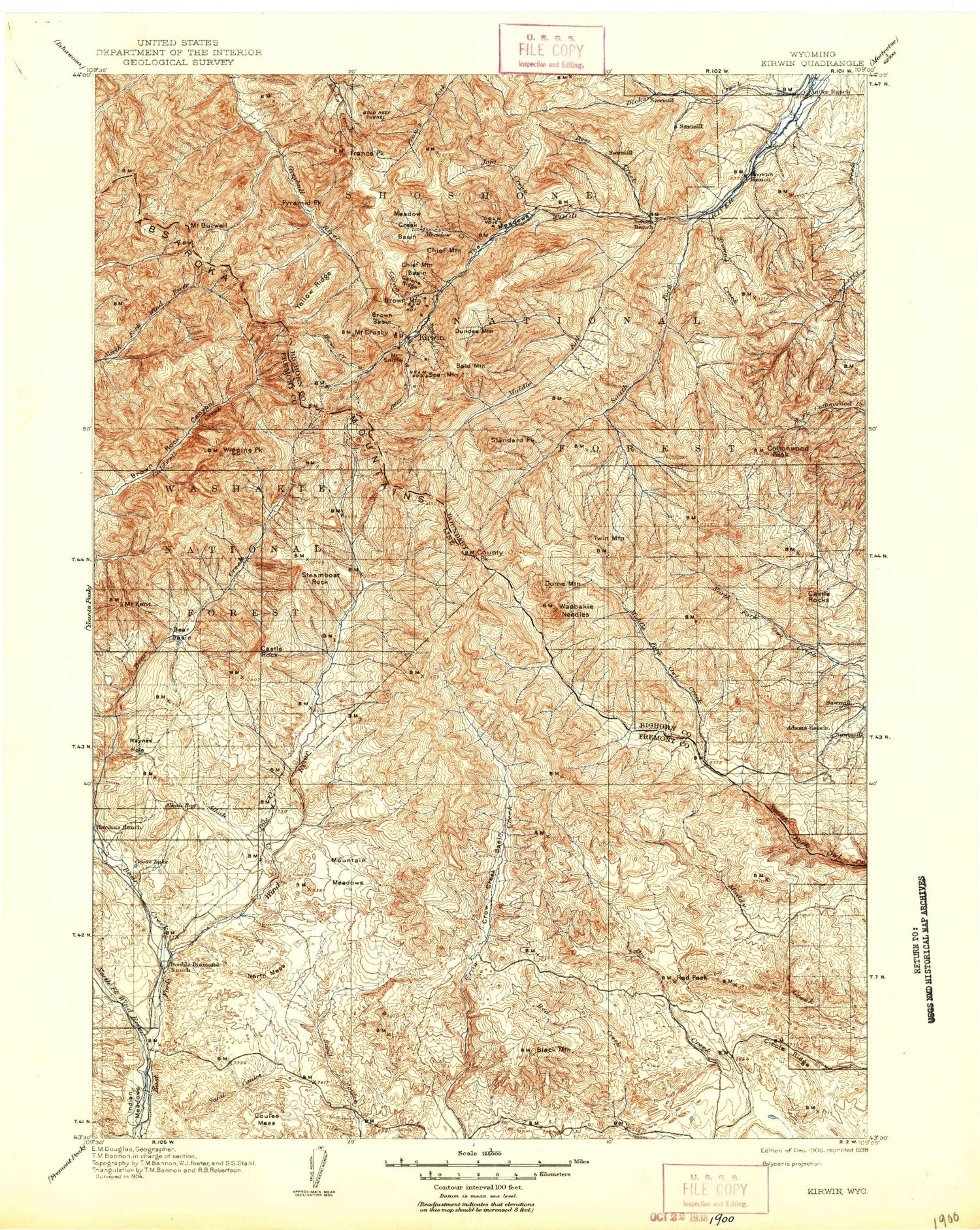
Historical USGS topographic map of Kirwin in the state of Wyoming. Scale: 1:125000. Print size: 17" x 24"
This map was published in 1906 and is in the following counties: Fremont, Hot Springs, Park.
The map contains contour lines, roads, rivers, towns, streams, and lakes. Printed on high-quality waterproof paper with UV fade-resistant inks.
Contains the following named places: Absaroka Range, Alkali Basin, Alkali Bog, Alkali Creek, Bain Creek, Bain Draw, Bald Mountain, Bear Basin, Bear Creek Canyon, Bear Creek Pass, Beaver Creek, Beaver Creek, Black Mountain, Brown Mountain Campground, Bryan Mine, Buck Creek, Button Draw, Cascade Creek, Cascade Creek Trail, Castle Creek, Castle Rock, Cave Creek, Circle Ridge, Circle Ridge Oil Field, Coal Chute Pass, Cottonwood Peak, County Peak, Crow Creek Basin, Crow Creek Canyon, Crow Mountain, Curry Creek, Deer Creek, Diamond Ridge, Dick Creek Lakes, Dollar Mountain, Double D Ranch, Double Diamond Ranch, Dugout Creek, Dunrud Peak, East Fork Basin, East Fork East Fork Wind River, East Fork Guard Station, East Fork Pass, Elk Ridge, Fall Creek, Finley Ranch, Finley Ridge, Flying T Ranch, Goose Lake, Greybull Pass, Harvey Draw, Horse Draw, Johnson Draw, Jojo Lake, Kanaugh Lake, Lake Creek, Lake Draw, Lean-to Creek, Castle Rocks, Long Meadows, Love Draw, Lower Table, Maverick Spring Dome, Meadow Creek, Mineral Mountain, Name Creek, Needle Creek, Ninemile Trail, North Branch Middle Fork Owl Creek, Pickwick Mine, Pine Creek, Pole Creek, Porter Cabin Cow Camp, Rattlesnake Ridge, Red Gulch, Red Peak, Sheep Creek, Slab Creek, Smuggler Gulch Trail, Smuggler Mine, Mount Sniffel, Spar Mountain, Spear Creek, Spring Creek, Spring Mountain, Steamboat Rock, Tepee Creek, Tepee Creek Trail, The Meadows, Trail Ridge, Tumlum Mine, Twin Lakes, Upper Table, Vincent Cabin, Waynes Creek, Waynes Creek Range Experiment Station, Waynes Hole, Wildcat Creek, Willow Creek, Wind River Trail, Windmill Draw, Wood River Campground, Timber Creek Trail, Trail Creek, Bain Place, Collins Place, Absaroka Trail, Additional Creek, Anaconda Mine, Avalanche Creek, Bald Mountain, Bear Creek, Bear Creek, Bear Creek Trail, Black Canyon, Black Draw, Blanchette Creek, Blue Creek, Bonne Creek, Brown Basin, Brown Creek, Brown Mountain, Brown Rock Canyon, Buckle Creek, Buckle Draw, Burwell Pass, Mount Burwell, Cabin Creek, Calf Creek, Canyon Creek, Cherry Creek, Chief Mountain, Chimney Creek, Cow Creek, Mount Crosby, Crow Creek Basin, Deadman Creek, Devils Hole, Dick Creek, Dome Mountain, Dundee Creek, Dundee Mountain, East Fork South Fork Wood River, East Fork Trail, Fall Creek, Francs Peak, Galena Basin, Galena Creek, Galena Ridge, Gold Reef Tunnel, Golden Ridge Tunnel, Gooseberry Trail, Greybull River Trail, Guard Station Park, Gwinn Fork, Hall Creek, Horse Creek, Hulse Creek, Iowa Mine, Jojo Creek, Jojo Mountain, Mount Kent, Kirwin, Klicker Creek, Larson Ranch, Last Creek, Little Johnnie Mine, Longhorn Mine, Mabel Creek, Manilla Mine, Mattice Tunnel, McGregor Park, Meadow Creek, Meadow Creek Basin, Mendota Mine, Middle Fork Wood River, Middle Gooseberry Creek, Molly Logan Mine, Muddy Monument Peak, Needle Creek, Nelson Ditch, Noon Point, North Cow Creek, Oregon Mine, Pearce Creek, Pease Draw, Pyramid Creek, Pyramid Peak, Quaking Aspen Creek, Rennerberg Creek, Rock Creek, Rock Creek Trail, Slaughter Creek, Smuggler Gulch, South Fork Dick Creek, Spar Creek, Standard Peak, Surveyor Park, Trail Creek, Twin Peaks, Vass Creek, Washakie Needles, West Gooseberry Creek, Wiggins Fork, Wiggins Peak, Willow Creek, Wind River Trail, Wolf Shaft, Wood River Guard Station, Yellow Creek, Yellow Ridge, Little Dry Creek, Steer Creek, Circle Ditch, North Fork Dick Creek, South Fork Wood River, Greybull River Trail, East Fork Elk Winter Pasture, Castle Rocks, Gwinn Fork Dick Creek, Mountain Meadows, Double Diamond Number 1 Reservoir Dam, Double Diamond Number 1 Reservoir, Bitterroot Number 1 Dam, Bitterroot Number 1 Reservoir, Yetter Brothers Sawmill, Gold Reef Mining Region, Circle Ridge Anticline Number One Mine, Circle Ridge Anticline Number Three Mine, Circle Ridge Anticline Number Five Mine, Absaroka Mountains Number One Mine, Absaroka Mountains Number Two Mine, Absaroka Mountains Number Three Mine, Absaroka Mountains Number Four Mine, Absaroka Mountains Number Five Mine, Red Creek Number One Mine


