MyTopo
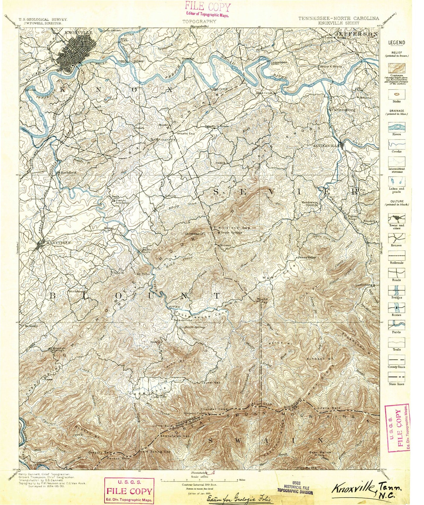
Historic 1895 Knoxville Tennessee 30'x30' Topo Map
Couldn't load pickup availability
Historical USGS topographic map of Knoxville in the state of Tennessee. Scale: 1:125000. Print size: 17" x 24"
This map was published in 1895 and is in the following counties: Blount, Jefferson, Knox, Monroe, Sevier, Swain.
The map contains contour lines, roads, rivers, towns, streams, and lakes. Printed on high-quality waterproof paper with UV fade-resistant inks.
Contains the following named places: Big Grill Ridge, Lawson Gant Lot, Little Abrams Gap, Maple Sugar Gap, Mud Gap, Starkey Gap, The Narrows, Cold Spring Gap, Gregorys Little Bald, Little Bald, Great Smoky Mountains National Park, Mount Davis, Hemlock Knob, Spence Field, Mount Squires, Buck Shank Branch, Blackoak Ridge, Brown Mountain, Chilhowee Mountain, Devils Branch, Duncan Creek, East Fork Little Pigeon River, Fall Branch, Fox Hollow Branch, Gann Branch, Grindstone Ridge, Hatcher Mountain, Hatcher Mountain, Hodge Branch, Huskey Branch, Indian Grave Gap, Island Home, Jakes Creek Trail, Kreider Branch, Left Prong Anthony Creek, Little River, Long Ridge, Meigs Post Prong, Pea Ridge, Pine Knot Branch, Rocky Ridge Branch, Shaw Grave Gap, Sheep Pen Gap, Sheepwalk Bluff, Shell Branch, Shields Branch, Shields-Watkins Field, Shinbone Ridge, Shooks, Shooks Gap, Shooks Gap, Shootly Branch, Shop Creek, Shop Ridge, Short Mountain, Shut-in Creek, Silers Creek, Silers Lead, Singleton Bend, Singleton Terminal, Sinkhole Mountain, Sixmile Branch, Skunk Ridge, Lake in the Sky, Slate Branch, Slate Quarry Hollow, Slaty Branch, Slay Bacon Hollow, Slick Limb Branch, Slide Hollow, Slide Hollow, Sloan Ridge, Smith Branch, Smith Hollow, Smith Knob, Snake Tongue, Soap Dam Creek, South Fork Crooked Creek, South Fork Ellejoy Creek, South Hall, South Knoxville, South Prong Waldens Creek, Southern Station, Spence Branch, Spicewood Branch, Spicy Gap, Splatter Branch, Split Branch, Spring Branch, Spring Creek, Spring Hollow, Springbrook Park, Springfield Branch, Springhouse Hollow, Spruce Double, Spruce Double Branch, Spruce Flats, Spruce Flats Branch, Starkey Creek, Starkey Gap, Starkey Hollow, Steep Branch, Stickbait Branch, Stillhouse Branch, Stillhouse Branch, Stillhouse Hollow, Stock Creek, Stone Camp Branch, Stony Branch, Stony Gap, Stony Ridge, Straight Cove Branch, Strickler Branch, Striped Hollow, Sugar Camp Branch, Sugar Camp Knob, Sugar Cove Branch, Sugar Cove Prong, Sugar Cove Ridge, Sugar Hollow, Sugar Orchard Branch, Sugarland Branch, Sugarland Mountain Trail, Sugarloaf Mountain, Sugartree Gap, Swampy Branch, Sweat Hill, Sweet Creek, Sweet Gum Branch, Sweetwater Branch, Tanager Branch, Tarkiln Branch, Tarkiln Gap, Tarkiln Ridge, Tater Branch, Tater Ridge, Tedford Branch, Temple Branch, The Flats, The Hogback, The Sinks, The Sugarlands, The Wolfhook, Third Branch, Third Creek, Thunderhead Prong, Tilda High Top, Tilda Ridge, Timber Ridge, Tinsley Pond, Tipton Branch, Tipton Spring Branch, Tipton Station, Tiptons Sugar Cove, Tiptons Sugar Cove Branch, Titmouse Branch, Tom Henry Branch, Top of the World Estates, Townsend, Trotter Bluff, Trotter Camp, Trunk Branch, Tuckahoe Creek, Turkeypen Branch, Turkeypen Ridge, Turnback Branch, Turner Branch, Twomile Branch, Twomile Lead, Underwood Bend, Underwood Branch, Upland Branch, Upper Buckhorn Gap, Upper Chestnut Flats, Upper McCammon Island, Valley Branch, Valley Ridge, Vee Hollow, Vestal, Victory Branch, Vista Trail, Walker Branch, Walker Fields, Walker Hollow, Walland, Wars Branch, Water Hollow, Watercrease Branch, Watertank Branch, Wear Cove Gap, Weasel Branch, Webb Branch, Webb Branch, Webb Cove, Webb Knob, Wedge Ridge, West Fork Gists Creek, West Fork Third Creek, West Knoxville, West Maryville, West Prong Little Pigeon River, West Springbrook, West View, Whetstone Ridge, Whistlepig Branch, Whistling Branch, Whistling Gap, Whiteoak Flats Branch, Whittle Mountain, Wilburn Branch, Wildcat Branch, Wildcat Hollow, Wildcat Spur, Wildwood, Wilkinson Ridge, Williams Branch, Williams Creek, Wilson Branch, Wise Hill, Witt Hollow, Wolf Creek, Wolfpen Gap, Woodchuck Branch, Woodfield Park, Yellow Knob, Yellow Spring Hollow, Yettland Park, Zack Ridge, Crooked Creek, Abrams Creek Campground, Abrams Falls, Abrams Falls Trail, Abrams Gap, Abrams Ridge, Ace Gap, Alder Branch