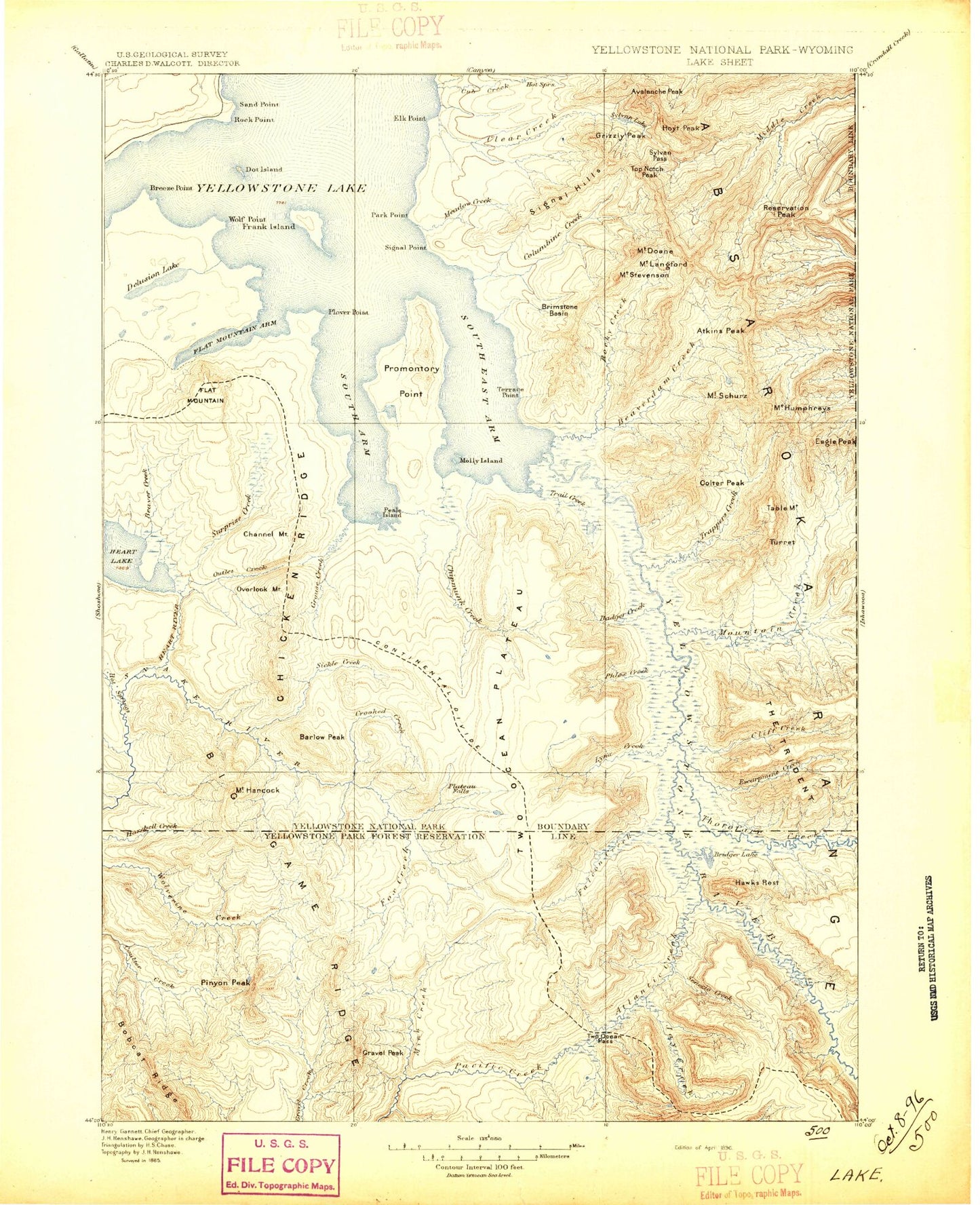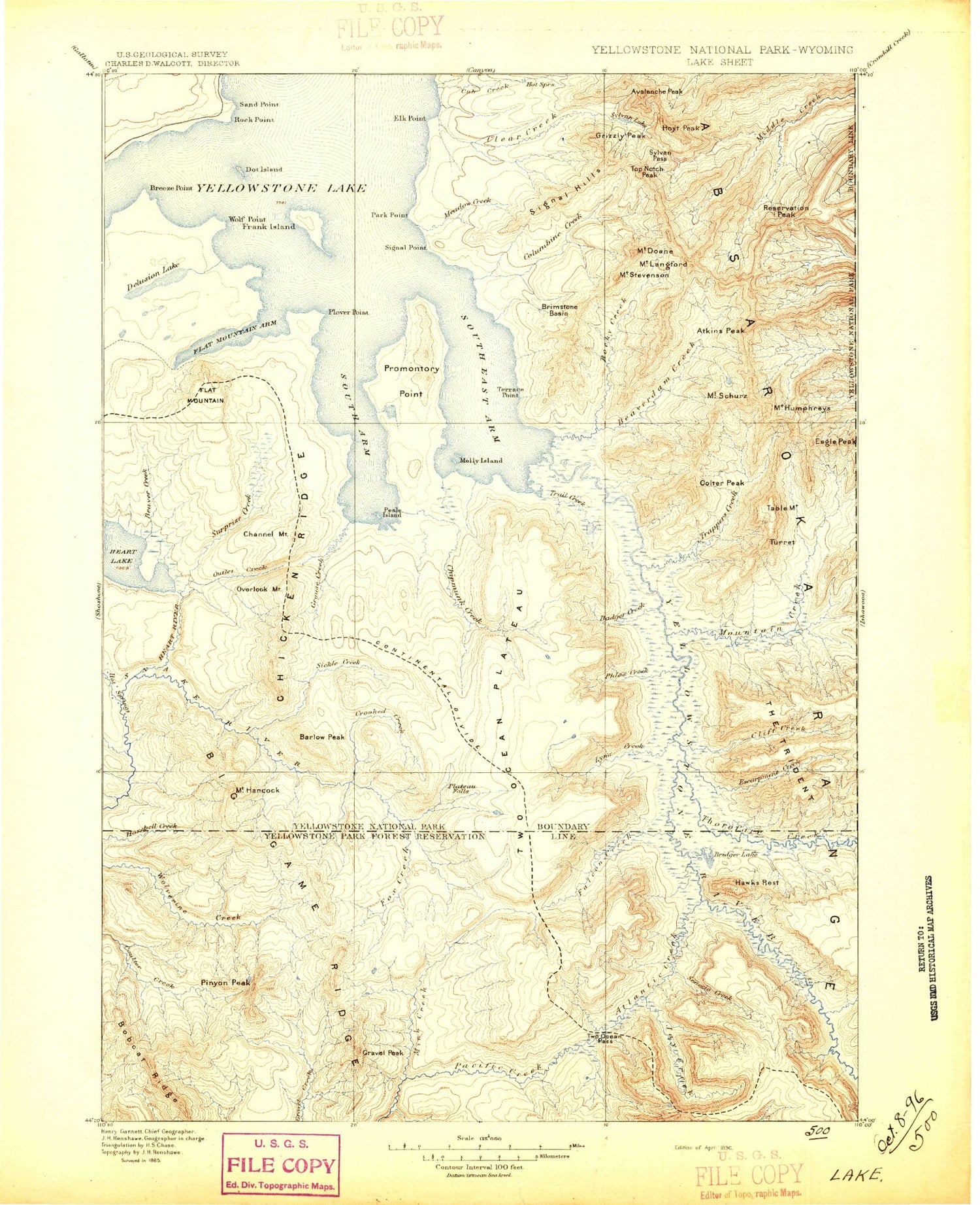
MyTopo
Historic 1896 Lake Wyoming 30'x30' Topo Map
Couldn't load pickup availability
Historical USGS topographic map of Lake in the state of Wyoming. Scale: 1:125000. Print size: 17" x 24"
This map was published in 1896 and is in the following counties: Fremont, Park, Teton.
The map contains contour lines, roads, rivers, towns, streams, and lakes. Printed on high-quality waterproof paper with UV fade-resistant inks.
Contains the following named places: Alder Lake, Beaver Creek, Cabin Creek, Cabin Creek Patrol Cabin, Channel Mountain, Cowdell Waste Water Ditch, Crooked Creek, Delusion Lake, Dot Island, Eagle Bay, Eagle Pass, Eagle Peak, Elk Point, Flat Mountain, Flat Mountain Arm, Fox Creek Patrol Cabin, Frank Island, Heart Lake Patrol Cabin, Mount Humphreys, Meadow Creek, Molly Islands, Outlet Creek, Outlet Lake, Overlook Mountain, Park Point, Park Point Patrol Cabin, Passage Creek, Peale Island, Plover Point, Rock Point, Sand Point, Mount Schurz, Signal Point, Snipe Point, South Arm, Table Mountain, Terrace Point, Trail Creek, Trail Creek Patrol Cabin, Trail Creek Trail, Trail Lake, Wolf Point, Langford Cairn, Terrace Point, Trail Creek, Trail Creek Trail, The Trident, Molly Island, Southeast Arm, Heart Lake, Trail Creek Trail, Alluvium Creek, Arthur Peak, Atkins Peak, Atlantic Creek, Avalanche Peak, Badger Creek, Barlow Peak, Basin Creek, Beaverdam Creek, Big Game Ridge Cutoff Trail, Bobcat Ridge, Bridger Lake, Brimstone Basin, Burnt Creek, Camp Creek, Castle Creek, Chicken Ridge, Chipmunk Creek, Clear Creek, Clear Creek Trail, Cliff Creek, Columbine Creek, Cub Creek, Daniels Creek, Mount Doane, East Entrance Ranger Station, Eleanor Lake, Elk Creek, Emerald Lake, Ermine Creek, Escarpment Creek, Evermann Creek, Falcon Creek, Fox Creek, Fox Park Flat, Fox Park Patrol Cabin, Gravel Creek Patrol Cabin, Gravel Lake, Gravel Peak, Grizzly Peak, Grouse Creek, Mount Hancock, Harebell Creek Patrol Cabin, Hawks Rest, Hawks Rest Patrol Cabin, Heart Lake Trail, Heart River, Hoyt Peak, Jay Creek, Mount Langford, Lynx Creek, Mariposa Lake, Coulter-Wolverine Cutoff Trail, Mink Creek, Mink Creek Cutoff Trail, Mountain Creek, Mountain Creek Trail, North Two Ocean Creek, Phelps Pass, Phlox Creek, Pinyon Peak, Plateau Creek, Plateau Falls, Reservation Peak, Rocky Creek, Senecio Creek, Sickle Creek, Signal Hills, Snake River Trail, Snowslide Creek, South Two Ocean Creek, Mount Stevenson, Surprise Creek, Sylvan Lake, Sylvan Pass, Third Creek, Thorofare Creek, Thorofare Ranger Station, Thorofare Trail, Top Notch Peak, Trail Creek, Trident Plateau, Two Ocean Pass, Two Ocean Plateau Trail, Weasel Creek, West Cutoff Trail, Wolverine Creek, Yellowstone Point, Howell Creek, Teton Wilderness, Yellowstone Trail, Monument Cairn, Tri-county Lake, Coulter Creek Tail, Parting of the Waters Natural Landmark, Big Game Ridge, Breeze Point, Colter Peak, Plenty Coups Peak, The Promontory, Trappers Creek, Turret Mountain, Yellowstone Lake, Two Ocean Plateau