MyTopo
Historic 1894 Lampasas Texas 30'x30' Topo Map
Couldn't load pickup availability
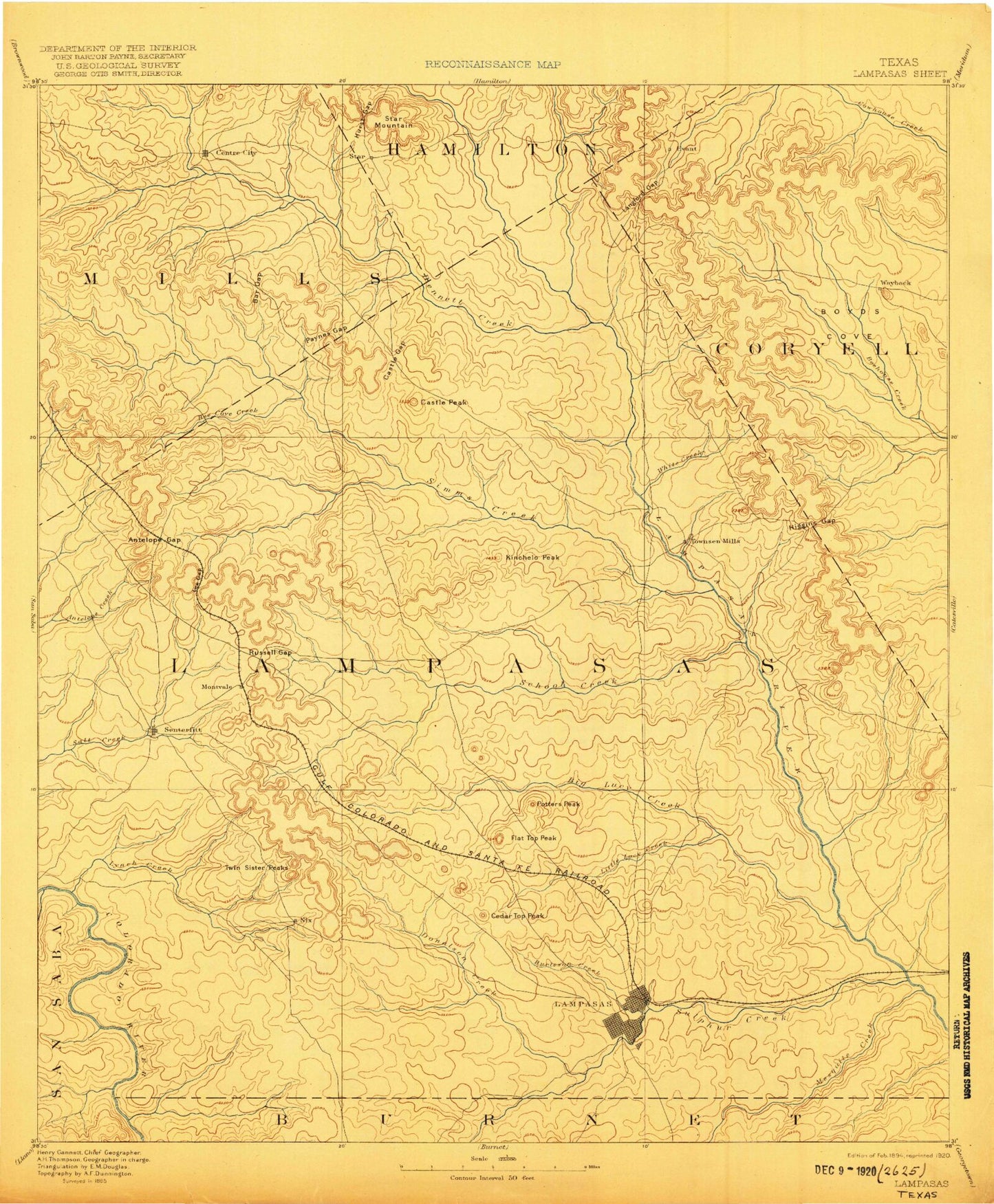
Historical USGS topographic map of Lampasas in the state of Texas. Scale: 1:125000. Print size: 17" x 24"
This map was published in 1894 and is in the following counties: Burnet, Coryell, Hamilton, Lampasas, Mills, San Saba.
The map contains contour lines, roads, rivers, towns, streams, and lakes. Printed on high-quality waterproof paper with UV fade-resistant inks.
Contains the following named places: Bean Creek, Reservoir Number Four, Adamsville, Antelope Gap, Barr Gap, Bear Cove Creek, Bear Creek, Beartrack Canyon, Bee Cave Creek, Bee Cove Creek, Bee Hollow, Bee House, Belton Gap, Bennett Creek, Big Thicket, Blue Cut, Boys Peak, Brahma Canyon, Bread Tray Mountain, Browns Creek, Buck Hollow, Buckhorn Branch, Bull Knob, Bullard Creek, Burleson Branch, Burleson Creek, Buzzard Mountain, Carter Mountains, Castle Gap, Castle Peak, Cave Pond, Cedar Top Peak, Cemetery Creek, Center City, Chalk Gap, Charley Springs Mountain, Coffin Springs Canyon, Cracker Neck, Crawford Mountain, Cromeans Creek, Cub Hollow, Deadmans Cut, Denmoe Cove, Denson Branch, Devils Hollow, Donalson Creek, Dugout Creek, Eagle Draw, East Fork Sulphur Creek, Espy Branch, Evant, Fall Creek, Flat Top Peak, Fletchers Gap, Fletchers Point, Franklin Mountain, Freeman Branch, Gholson Gap, Gibson Branch, Gooch Branch, Goodland Ridge, Gorman Creek, Gorman Falls, Grassy Knob, Graveyard Hollow, Greenwood Mountain, Gunderland Park, Hancock Park, Happy Hollow, Heatley Branch, High Gate, Hog Hollow, Horsethief Cove, Horsetooth Gully, Howard Hollow, Hughes Creek, Hughes Hollow, Hurley Hollow, Hurst Gap, Indian Bluff, Indian Camp Draw, Indian Creek, Indian Point, Indian Water Hole, Jackson Ranch, Kemp Lake, Kempner, Kinchelo Creek, Kirby Creek, Knight Mountain, Lampasas, Langford Branch, Lee Gap, Lemons Ridge, Lemons Springs Camp, Live Oak Gap, Live Oak Ridge, Lometa, Long Branch, Long Cove, Long Hollow, Lucy Creek, Lynch Creek, Lynch Creek, Lynn Cove, McAnelly Creek, McCrea Branch, McCrea Tank, McNett Creek, Mesquite Creek, Messanger Mountain, Mill Branch, Mustang Creek, Nesbitt Branch, Nix, North Fork Yancey Creek, North Simms Creek, North Turkey Creek, Old Letdown Point, Onion Top, Owens Branch, Panther Draw, Patterson Creek, Patterson Ridge, Payne Branch, Payne Gap, Payne Mountain, Pecan Branch, Pecan Draw, Pecan Spring Branch, Pigfoot Hollow, Pillar Bluff, Pillar Bluff Creek, Pitt Creek, Plum Hollow, Pole Bar Canyon, Post Oak Creek, Post Oak Draw, Post Oak Falls, Post Oak Ridge, Quail Ridge, Radio Junction, Rattlesnake Branch, Rattlesnake Draw, Red Rock Canyon, Reservoir Number One, Reservoir Number Two, Revision, Road Hollow, Road Hollow Creek, Roberts Creek, Rocky Point, Round Mountain, Russell Branch, Russell Gap, Sand Hollow, Sand Tank, Scott Hollow, Simms Creek, Slaughter Branch, Smith Ranch, Snipes Cove, Soldiers Spring Creek, South Bennett Creek, South Fork Yancy Creek, South Turkey Creek, Southwest Ledge Quarries, Spicewood Creek, Star, Star Mountain, Sullivan Knob, Sulphur Creek, Tie Slide Creek, Turkey Creek, Twin Mountain, Twin Mountains, Twin Sister Peaks, Upper End Tank, Van Winkle Gulch, Vann Branch, Vann Camp, Vann Ranch, Waggoner Gap, Waters Mountain, Willow Springs Branch, Windy Canyon, Wolf Hollow, Yancey Creek, Yates Branch, Barkley Creek, Bear Branch, Cherokee Creek, Dry Branch, Jennings Creek, Little Lucy Creek, Middle Bennett Creek, North Bennett Creek, North Fork Lynch Creek, School Creek, Brooks Crossing, Fairview, Faubion Crossing, Hallmark Crossing, Izoro, Moline, Pearl, Pleasant Grove, Rumley, Scallorn, Senterfitt, Shortall, Sparks Crossing, Reservoir Number Three, Lampasas County, Evant Pumping Station, Lampasas Pumping Station, Middle Fork Yancey Creek, Soil Conservation Service Site 5 Dam, Soil Conservation Service Site 5 Reservoir, Soil Conservation Service Site 9 Dam, Soil Conservation Service Site 9 Reservoir, Soil Conservation Service Site 7 Dam, Soil Conservation Service Site 7 Reservoir, Soil Conservation Service Site 6 Dam, Soil Conservation Service Site 6 Reservoir, Soil Conservation Service Site 3 Dam, Soil Conservation Service Site 3 Reservoir, Soil Conservation Service Site 2 Dam, Soil Conservation Service Site 2 Reservoir, Soil Conservation Service Site 1 Dam, Soil Conservation Service Site 1 Reservoir, Lometa Reservoir Dam, Santa Fe Lake, Soil Conservation Service Site 4 Dam, Soil Conservation Service Site 4 Reservoir, Soil Conservation Service Site 8 Dam