
MyTopo
Historic 1887 Lewisburg West Virginia 30'x30' Topo Map
Couldn't load pickup availability
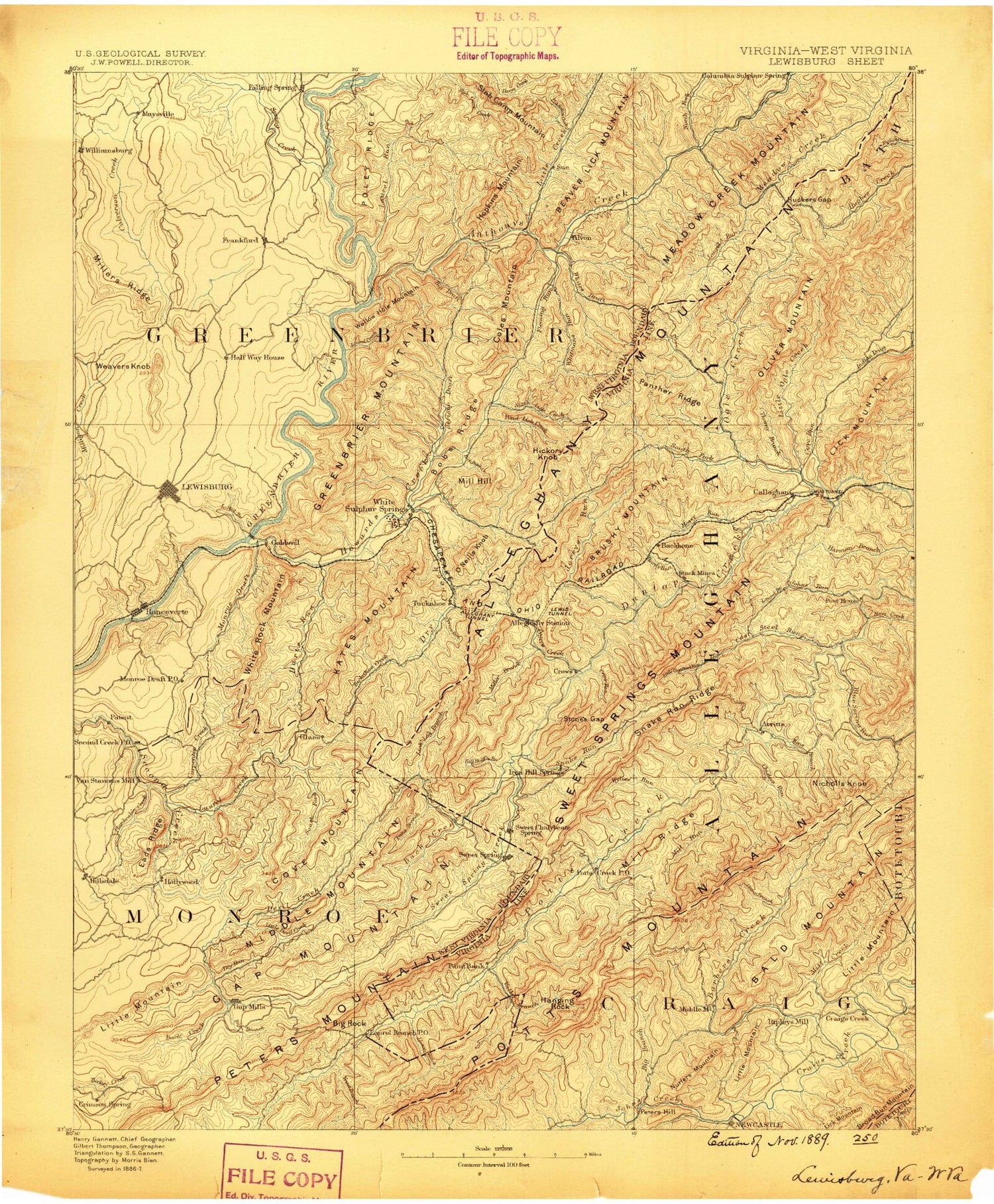
Historical USGS topographic map of Lewisburg in the state of West Virginia. Scale: 1:125000. Print size: 17" x 24"
This map was published in 1887 and is in the following counties: Alleghany, Bath, Botetourt, Covington (city), Craig, Greenbrier, Monroe.
The map contains contour lines, roads, rivers, towns, streams, and lakes. Printed on high-quality waterproof paper with UV fade-resistant inks.
Contains the following named places: Allegheny Mountain Trail, Allegheny Tunnel, Batick Mountain, Big Branch, Big Ridge, Cove Creek, Ewin Run, Hickory Knob, Jerrys Run, Little Mountain, Peters Mountain, Potts Mountain Trail, Rucker Gap, Sweet Spring Creek, Fletcher Knob, Smith Knob, Chestnut Knob, Boggs Hightop, Buckeye Creek, Burns Run, Carpenter Creek, Chestnut Flat, Coffman Hill, Daniels Ridge, Hokes Mountain, Jones Mountain, Laurel Branch, Lewisburg, Miller Ridge, Milligan Creek, Monroe Draft, Ronceverte, Sinking Creek, Spruce Run, Thorny Hollow, Weaver Knob, Williamsburg, Boardinghouse Run, White Rock Mountain, North Caldwell, Richlands, Whitmans Draft, Alexander Hollow, Allegheny Mountain Trail, Allegheny Tunnel, Alvon, Anthony Creek, Archer Fork, Auto, Back Creek, Back Creek, Back Hollow, Back Valley, Barnes Lick Run, Beaver Lick Mountain Trail, Big Branch, Big Draft, Big Run, Big Run Trail, Blue Bend, Blue Bend, Blue Bend Loop Trail, Blueline Hollow, Blueline Trail, Bobs Ridge, Boggs Run, Boulder Run, Broad Run, Browns Hollow, Brushy Ridge, Camp Wood, Cat Rock Hollow, Civil War Trail, Coles Mountain, Coles Mountain Trail, Coles Run, Cove Creek, Culverson Creek, Dawson Run, Devil Creek, Diley Trail, Dodson Branch, Dry Creek, Dry Run, Dry Run, Dutch Hollow, Dynamite Hollow, Eads Ridge, Ewin Run, Falling Spring, Fleming Run, Fletcher Hollow, Fletcher Ridge, Forest Run, Gap Mills, Gap Mountain, Government Floyd Monument, Greenbrier Mountain, Greenbrier River Trail, Greenbrier State Forest, Greenbrier Youth Camp, Grindstone Ridge, Gunpowder Ridge, Harts Run, Harts Run, Harts Run Camping Area, Henning, High Head Mountain, Hollywood, Hopkins Mountain, Howard Creek, Humphreys Draft, Humphreys Draft Trail, Indian Creek, Jericho Draft, Kates Mountain Overlook, Keenan, Keister, Kitchen Creek, Lake Sherwood Trail, Laurel Branch, Laurel Branch, Laurel Creek, Laurel Creek, Laurel Run, Laurel Run, Laurel Run Trail, Lisa Jane Hollow, Little Allegheny Mountain, Little Allegheny Mountain Trail, Little Creek, Little Devil Creek, Little Laurel Creek, Little Mountain, Long Spur, Lynch Hollow, Lynn Lick Run, Mays Draft, Meadow Creek, Middle Mountain, Moncove Lake, Moss Mountain, Mudlick Hollow, Neola, North Fork Anthony Creek, O'Neill Knob, Old House Run, Onemile Run, Panther Lick Run, Panther Ridge, Peach Orchard Ridge, Peach Orchard Trail, Pedro, Poley Ridge, Pond Lick Run, Pond Lick Run, Quarry Hollow, Rayburn Draft, Red Run, Roaring Mountain, Rock Lick Run, Rocky Run, Sharp Hollow, Simms Run, Slabcamp Trail, Slash Lick Run, South Boundary Trail, Spring Creek, Steam Mill Hollow, Stony Run, Sue, Sulphur Lick Run, Sweet Springs, Sweet Springs Creek, Thacker Draft, Trout Branch, Tuckahoe, Tuckahoe Run, Turkeypen Run, Twomile Run, Wades Creek, Waids Draft, Whites Draft, Wicks Knob, Wild Meadow, Wiley Run, Youngs Nature Trail, Sweet Springs Valley, Blue Bend Campground, Gunpowder Ridge Overlook, Anthony Boat Launch, Boardinghouse Run, Schuirmann Hollow, National Fish Hatchery, White Sulphur District Ranger Office, Slabcamp Trail, Wild Meadow Trail, Anthony, Bowes, Brantville, Brushy Mountain, Brushy Mountain, Butler Mountain, Caldwell, Carroll Hill, Centennial, Clendenenville, Cove Mountain, Crimson Springs, Daugherty Mountain, Dickson, Dorr, Elk Knob, Fairlea, Frankford, Gardner, Gates, Glace, Hanging Rock, Hillsdale, Hominy Hill, Hopper, Kates Mountain, Loopemount, Mapledale, Maxwelton, McGlone, Monitor, Organ Cave, Patton, Round Mountain, Roxalia, Secondcreek, Shryock, Spring Creek, Sunlight


