MyTopo
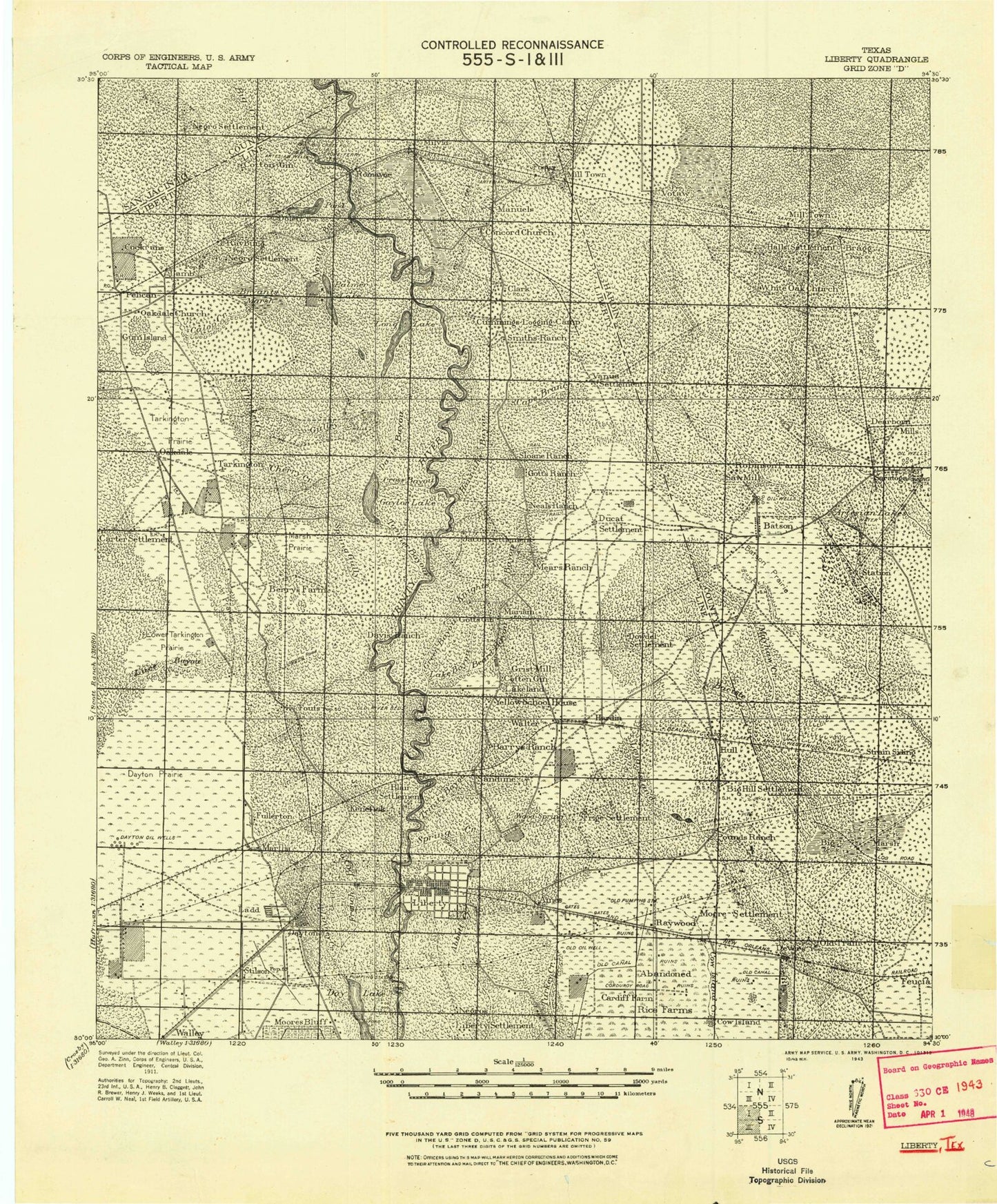
Historic 1943 Liberty Texas 30'x30' Topo Map
Couldn't load pickup availability
Historical USGS topographic map of Liberty in the state of Texas. Scale: 1:125000. Print size: 19" x 24"
This map was published in 1943 and is in the following counties: Hardin, Liberty, Polk, San Jacinto.
The map contains contour lines, roads, rivers, towns, streams, and lakes. Printed on high-quality waterproof paper with UV fade-resistant inks.
Contains the following named places: Abbott Creek, Ames, Arizona Creek, Barrett Bayou, Bass Baygall, Batiste Creek, Batiste Prairie, Batiste Woods, Batson, Batson Oil Field, Batson Prairie, Beards Marsh, Big Bayou, Black Land Slough, Blau Gully, Lake Liberty, Bowie Creek, Bull Tongue Creek, Buzzard Roost Lake, Cade Lake, Capers Ridge, Cross Bayou, Daisetta, Daisetta Swamp, Daniel Ranch, Davis Hill, Day Lake, Dayton, Deer Gully, Devers, Double Lakes, Duncan Lake, Fields Lake, Fitz Lake, French Bayou, French Creek, Gaylor Creek, Gaylor Lake, Gillen Bayou, Graveyard Hill, Greens Bayou, Griffin Pond, Gum Slough, Hanners Bend, Hanners Bend Lake, Hardin, Hardin Lake, Hardin Oil Field, Hawkins Hill, Hayes Park, Horseshoe Lake, Horseshoe Lake, Horseshoe Lake, Hull, Hull Oil and Gas Field, Jack Williams Lake, Jerome Slough, Josie Bayou, Josie Lake, Keys Camp, Kinky Branch, Knight Bayou, Lake Bayou, Lewis Lake, Liberty, Linney Creek, Little Bayou, Little Brushy Lake, Long Island Cove, Long Island Creek, Long Island Woods, Long John Creek, Lost Lake, Made Lake, Martha Oil Field, Mayhaw Creek, Mayhaw Prairie, Mayhaw Slough, McMurtry Bayou, Minner Slough, Morris Camp, Mud Lake, Mud Lake, Neds Gully, New Batson Oil Field, New Old River Lake, North Dayton Oil Field, Old River Lake, Otter Lake, Palmer Bayou, Payne Lake, Pecan Lake, Rayburn Lake, Raywood, Rosewood Lake, Rosewood Lodge, Round Lake, Sams Prairie, Sand Lake, Saratoga, Saratoga Oil Field, Sevenmile Bend, Shinglemill Slough, Snag Lake, South Liberty Oil Field, Stockpen Prairie, Striplin Marsh, Stumpy Lake, Taso Cove, Taylor Camp, The Forks, Thorson Gully, Turkey Creek, Twin Lake, Walker Marsh, West End Slough, Willis Lake, Willow Cove, Wolf Gully, Wolf Point, Wood Spring Creek, Beaver Creek, Black Lake, Brushy Lake, Brushy Lake, Chain O'Lakes, Cherry Creek, Doe Pond Creek, Doe Ponds, Duke Lake, Dunnie Burnout, Fields Bayou, Hardwood Lake, Horseshoe Lake, Jayhawker Baygall, Long Lake, Long Lake, Lost Lake, McAnally Break, Meetinghouse Branch, Menard Creek, Mill Creek, New River Lake, Old Hat Burnout, Mason Lake, Peach Pond, Romayor, Rye, Sand Lake, Stub Lake, Thicket Siding, Union Well Creek, Votaw, Ward Prairie Lakes, Wild Cow Marsh, Williams Creek, Woods Lake, Adams Branch, Beef Head Creek, Black Creek, Board Slough, Brushy Lake, Clayton Bayou, Coon Slough, Devers Woods, Gum Gully, Prairie Marsh Gully, South Liberty Oil Field, Tanner Bayou, Tarkington Bayou, Tarkington Prairie, Beard Bayou, Cypress Lake, Duncan Lake, Hollins Lake, Indian Gulley, Lake Bowie, Lake Sam, Mill Creek, Tanners Bluff, White Roselake, Horse Shoe Bend Bayou, Pruett Bayou, Thickets Creek, Carter Settlement, New Hope, Dowdel Settlement, Marvels, Atascosito, Coushatta Village, Grand Cane, Franklin, Jacob Settlement, Lumm, Oakdale, Cow Island, Frige Settlement, Moore Settlement, Lakeland, Mariam, Fullerton, Ladd, Wadley, Ducat Settlement, Vanva Settlement, Big Creek, Spring Branch, Indian Ridge, Felicia, Hogpen Crossing, Kenefick, Macedonia, Martha, Moss Hill, Rattlesnake Bend, Rock Island, Sandune, Simmons Bottom, South Liberty, Stilson, Strain, Tanner Settlement, Woodson, Bragg, Clark, Fuqua, Milvid, Thicket, Cain Ridge, Cherry Creek, Coley Creek, Davison Bayou, Dolen, Dry Cherry Creek, Grama Grass Bottom, Hightower