MyTopo
Historic 1893 Little Rock Arkansas 30'x30' Topo Map
Couldn't load pickup availability
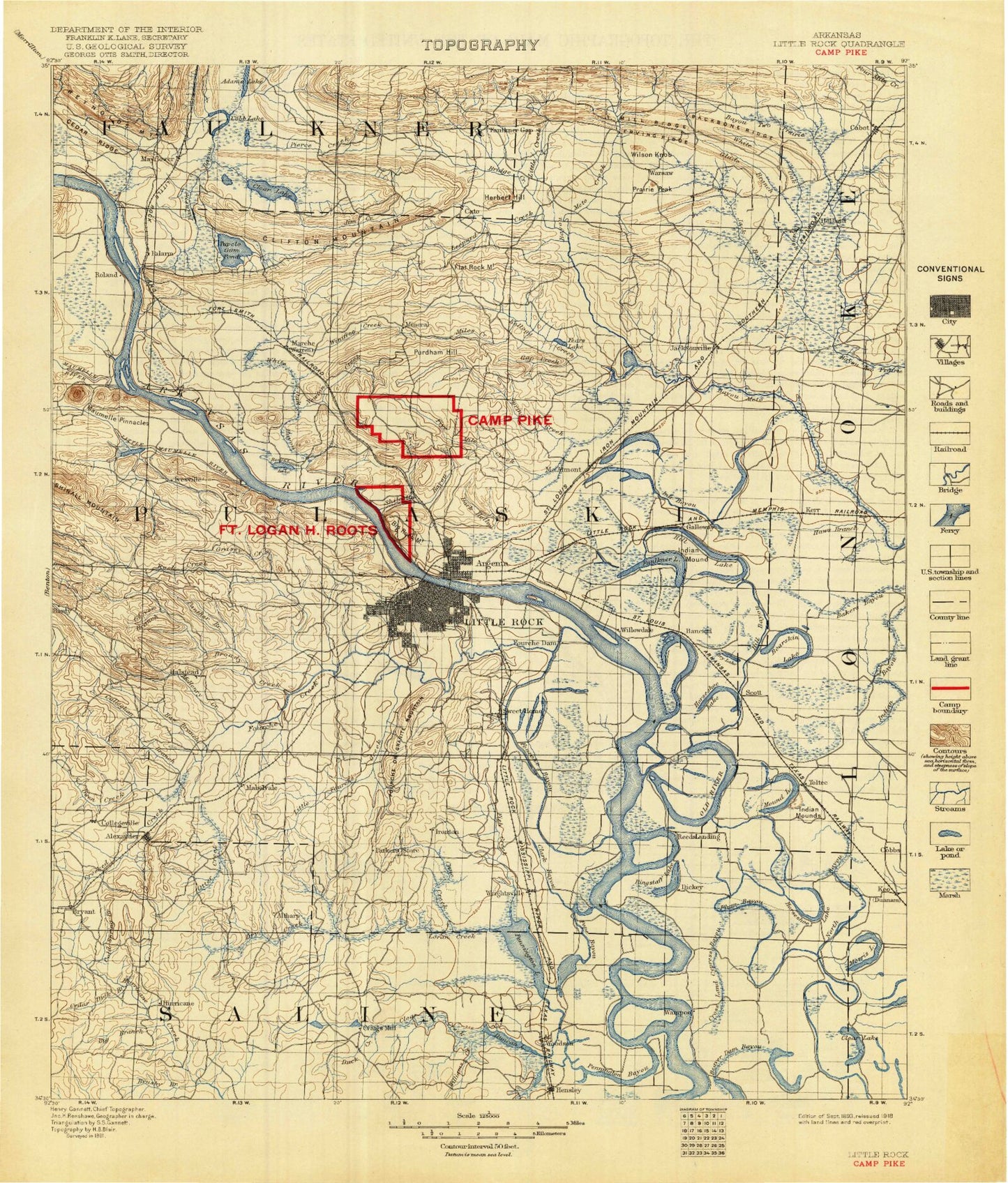
Historical USGS topographic map of Little Rock in the state of Arkansas. Scale: 1:125000. Print size: 18" x 24"
This map was published in 1893 and is in the following counties: Faulkner, Lonoke, Pulaski, Saline.
The map contains contour lines, roads, rivers, towns, streams, and lakes. Printed on high-quality waterproof paper with UV fade-resistant inks.
Contains the following named places: Dry Creek, Aldersgate Camp, Allsopp Park, Amboy, Ash Flat Lake, Ashley Bayou, Backbone Ridge, Baucum, Beaver Creek, Beaverdam Creek, Beaverdam Island, Bell Slough, Blue Branch, Boyle Park, Bredlow Corner, Bridge Creek, Brier Lick Branch, Broadmoor Shopping Center, Brushy Island, Burns Park, Burns Park Public Use Area, Butler Park, Camp Windemere, Campbell Bayou, Cane Creek, Cato, Cato Point, Cedar Ridge, Chadwick Creek, Clear Creek, Cobbs, Cold Spring Branch, Coleman Creek, Collegeville, Crooked Creek, Cross Pond, Crystal Valley, Cypress Branch, Cypress Pocket, Dark Hollow, Dooley Bend, Dortch Bend, Dubb Creek, Duck Creek, East End, Ellis Mountain, Emory Branch, Erving Ridge, Fairview, Faulkner Gap, Faulkner Lake, Fears Lake, Fish Creek, Flag Pond, Flat Rock Mountain, Fletcher Bend Public Use Area, Forty Point Lake, Fourche Island, Fourche Mountain, Gap Creek, Gar Slough, Gates Island, Gillam Park, Granite Mountain, Grassy Flat Creek, Haw Branch, Hindman Park, Ink Bayou, Iron Springs, Ironton, Jacks Bayou, Jay Creek, Jim Creek, Jimerson Creek, Kanis Park, Kelly Branch, Keo, Kuykendall Brake, Lakehill Shopping Center, Lamar-Porter Field, Landmark Branch, Ledbetter Branch, Leopard Creek, Little Creek, Little Maumelle River, Little Rock Gillett Levee, Little Rock Gillett Levee, Lone Cypress Brake, MacArthur Park, Maple Creek, McCright Branch, McHenry Creek, Mile Creek, Miles Creek, Mill Bayou, Mill Branch, Mill Ridge, Monnie Springs, Moren Branch, Morgan, Muddy Branch, Natural Steps, Newton Creek, North Bayou, Oak Grove, Old Channel Fourche Creek, Otter Creek, Owen Creek, Panther Branch, Panther Creek, Payne Branch, Pennington Bayou, Pierce Creek, Pine Ridge, Potter Creek, Purdham Hill, Rebsamen Park, Rector Brake, Reservoir Park, Rock Creek, Rock Ridge, Rocky Branch, Rocky Branch, Roland, Rosedale, Rottaken, Rounded Hill, Sardis, Scott, Scott Bayou, Sherman Park, Shilcotts Bayou, Snow Brake, Spring Creek, Spring Lake Club, Stark Bend, Steele Bend, Tates Mill, Thompson Branch, Toltec, Toneyville, Town and Country Shopping Center, Treadway Branch, Twen Cen, Union Valley, Vestal Park, Village Shopping Center, Vinson Branch, Warsaw, Westwood, White Oak Bayou, White Oak Branch, Willow Springs Branch, Wilson Knob, Woodruff Creek, Woodson, Wrightsville, Wrightsville Public Use Area, Chenault Island, Chenault Reach, Brittain, Galloway, Goodman, Hamiter, Holland, Macon, Alexander, Alexander Mountain, Ballard Landing, Base Line, Bear Den Mountain, Berger, Biddle, Big Rock Hill, Big Rock Mountain, Blue Hill, Booker, Brockington Corner, Brooks, Bryant, Cabot, Cammack Village, Cloverdale, Cook Mountain, Crafton Landing, Crystal Hill, Crystal Mountain, Dixie, Edwards Landing, Franklin Hill, College Station, Gentry Corner, Geyer Springs, Gillam Park, Gravel Ridge, Gum Springs, Haig, Higgins, Hot Springs Junction, Iron Ore Hill, Ivesville, Jacks Landing, Jacksonville, Jeffrey, Lakeside, Lakewood, Levy, Lignite, Martindale, McAlmont, Meadowcliff, Mitchell Hill, Mount Pilgrim, Oak Forest, Olmstead, Padgett Hill, Palarm, Pankey, Paradise Landing, Park Hill, Pecan Grove, Picron Hill, Pine Haven, Pinnacle, Pooles Landing, Prairie Peak, Protho Junction, Pulaski, Pulaski Heights, Rector Hill, Red Hill, Reynolds Mountain, Rixey, Rose City, Round Hill, Shannon Hills