MyTopo
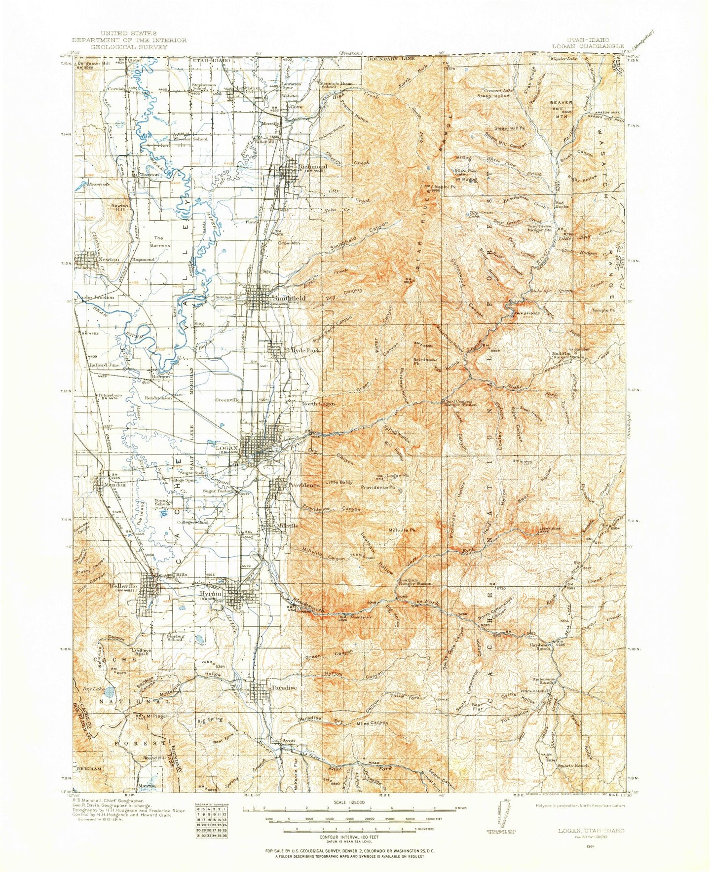
Historic 1914 Logan Utah 30'x30' Topo Map
Couldn't load pickup availability
Historical USGS topographic map of Logan in the state of Utah. Scale: 1:125000. Print size: 17" x 24"
This map was published in 1914 and is in the following counties: Bear Lake, Box Elder, Cache, Franklin, Rich.
The map contains contour lines, roads, rivers, towns, streams, and lakes. Printed on high-quality waterproof paper with UV fade-resistant inks.
Contains the following named places: Spring Creek, Bear River Range, Beaver Creek, Cub River, Peterson Hollow, Sink Hollow, South Canyon, Worm Creek, Utida, Anderson Ranch, Benson, Big Hill, Brushy Canyon, Butler Hollow, Camp Wapiti, Clay Slough, Cottle, Curtis Hollow, Deer Ridge, Fox Hollow, Gold Hill, Hardware Ranch, Horseshoe Bend, Lions Hollow, Little Mountain, Newton, Newton Branch West Cache Canal, Newton Creek, Newton Dam, Newton Reservoir, Pete McCombs Hill, Petes Hollow, Pullum Hollow, Ransom Hollow, Southwest Lewiston Canal, Swift Slough, The Barrens, The Island, The Point, Trenton, West Cache Canal, West Pump Canal, West Pump Canal, Blacksmith Fork, Riverside, Amalga, Ballard Junction, Cornish, Morton, Petersboro, Quigley Crossing, Cache National Forest, Wellsville-Mendon Lower Canal, Wellsville-Mendon Upper Canal, Adams Corral, Amalga Branch West Cache Canal, Amazon Hollow, Amazon Mine, Ant Valley, Avon, Babbit Shanty Hill, Bankhead Canyon, Basin Hollow, Baxter Pothole, Baxter Ridge, Bear Canyon, Bear Flat, Bear Hollow, Bear Hollow, Bear Hollow, Beaver Creek, Beaver Mountain, Beaver Mountain Ski Area, Beef Hollow, Beirdneau Campground, Beirdneau Hollow, Beirdneau Peak, Benson Canal, Big Baldy, Big Daley, Big Hill, Big Hollow, Big Hollow, Big Peavine, Big Spring Hollow, Birch Canyon, Bird Canyon, Black Peak, Blacksmith Fork, Blacksmith Fork Canyon, Blacksmith Fork Guard Station, Blacksmith Fork Nibley Canal, Blind Hollow, Blue Hill, Blue Spring Creek, Boar Hole, Bogus Hollow, Borden Reservoir, Bott Canyon, Boulder Mountain, Bowden Canyon, Box Elder Hollow, Bridger Campground, Browns Roll Off Campground, Brush Canyon, Bullen Hole, Bunchgrass Creek, Card Campground, Card Canyon, Card Canyon Guard Station, Cardon, Cart Hill, Cart Hollow, Cart Hollow, Cave Hollow, Cedar Hill, Charles Hollow, Cherry Creek, Cherry Creek Ditch, Cherry Peak, Chicken Creek, China Row Campground, Chokecherry Campground, Cinnamon Creek, City Creek, Clappers Hollow, Clark Hollow, Coldwater Canyon, College Ward, Cooks Cabin, Cooks Pond, Cookys Hollow, Cottonwood Canyon, Cottonwood Picnic Area, Cove, Cowley Canyon, Crab Ridge, Crescent Lake, Crescent Lake Canyon, Crooked Hollow, Crow Mountain, Curtis Creek, Cutler Reservoir, Dam Creek, Davenport Creek, Deep Canyon, Devils Gate Canyon, Dewitt Campground, Dip Hollow, Doubletop Mountain, Dry Canyon, Dry Canyon, Dry Canyon, Dry Curtis Creek, Dry Gulch, Dry Hollow, Dry Lake, Dry Pole Hollow, East Canyon, East Fork Little Bear River, East Pole Creek, East Pump Canal, Elbow Hollow, Elk Hollow, Mount Elmer, First Waterfall Hollow, Flat Bottom Canyon, Flat Bottom Hill, Fourmile Creek, Fourmile Hill, Friendship Campground, Garretts Hollow, Gibson Canyon, Mount Gog, Gold Mine Hill, Goring Pond, Green Canyon, Green Canyon, Greens Corner, Greenville, Guinavah Amphitheater, Guinavah Campground, Gus Lind Flat, Hansen Hollow, Hansen Pond, Hell Canyon, Hells Kitchen, Hells Kitchen Canyon, Herd Hollow, High Creek, High Creek Campground, High Creek Lake, Hills, Hog Hole, Holt, Hopkins Slough, Horse Lake, Hunsaker Corral, Hyde Park, Hyde Park Canal, Hyde Park Canyon, Hyrum, Hyrum Canal, Hyrum Canyon, Hyrum City Park, Hyrum Reservoir, Hyrum Slough, Indian Canyon, Indian Trail Hollow, Jackson Ditch, Mount Jardine, Jepsen Valley, Jim Taylor Canyon, Johnson Draw, Leatham Hollow, Left Hand Fork Blacksmith Fork Canyon, Lewiston, Lindleys Basin, Little Baldy, Little Ballard Creek, Little Bear Creek, Little Bear Pond, Little Bear River, Little Cottonwood Creek, Little Daley, Little Knoll, Little Left Hand Fork High Creek, Little Logan River, Little Peavine, Little Ricks Canyon, Lodge Campground, Logan, Logan and Hyde Park Canal, Logan Canyon, Logan Hyde Park and Smithfield Canal, Logan North Field Canal